
December Cold Wave Looming?
As you know, I am not a long-range weather forecaster. But, meteorologists who are experts in the field have been talking up a cold wave for the second half of December. It is starting to show up in the conventional data and I want to give you a heads up.
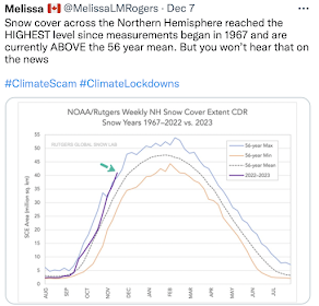
One of the elements for a major cold wave is greater than average snow cover. Right now, it is the highest since records began being kept in the 1960's!

Here are the corresponding forecasts:

8 to 14 Day Forecast
December 17-30 Forecast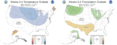

Tuesday and Tuesday Night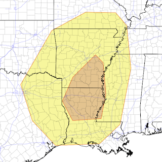 There is an enhanced risk of severe thunderstorms in the amber area and a lesser chance in the yellow area.
6 to 10 Day Forecast

8 to 14 Day Forecast

December 17-30 Forecast

Energy costs are going to increase significantly if these forecasts are correct. Please note that the period of colder than average weather will include Christmas. These forecasts imply travel issues (snow and ice) as well as extreme cold.
While we on the subject of long range forecasts, NWS Storm Prediction Center is forecasting the potential for out-of-season tornadoes and severe thunderstorms.
Monday and Monday Night

The area in yellow may see strong thunderstorms.
Tuesday and Tuesday Night

I'll update as we get closer to this event.


Comments
Post a Comment