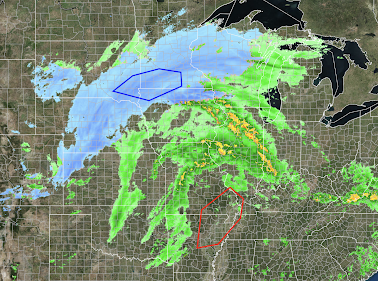
The blue is falling snow with the darker blues = heavier rates of snowfall. The dark blue polygon is where the heaviest rates of snow are likely through 6pm.
Farther south, the red polygon is where the first of the tornado-producing thunderstorms are forecasted to develop in the 4 to 6pm time range.
I will be updating this situation on Twitter @usweatherexpert.
More heavy rain (snow in the mountains) forecast. Rains have already begun over the southern two-thirds of the state. See 3:15pm radar below. In addition, there is small risk of a tornado, especially tomorrow morning, in coastal areas of Southern California, shown in dark green.
The title of this essay is from a press release that indirectly "blames the victim." The author is Sedgwick County Emergency Management regarding a fatal tornado that occurred just north of Wichita at 1:14 this morning. The tornado was rated EF-2 ("strong") intensity. I believe the wording is unfortunate as discussed below. Photo: KAKE.com. Note that with a basement, as little as seconds to dash down the stairs might have been sufficient to avoid injury. In what has increasingly and unfortunately become the norm in tornado situations, no NWS tornado warning was issued even though: Rotation was depicted on radar Radar shows lofted debris People from outside the NWS are observing tornadoes and bringing them to NWS's and the public's attention. I want to be clear: the tornado formed practically on top of the home and there was probably no way to have warned in time to help the man killed. But there is absolutely no reason a tornado warning could not have bee...
The NWS is forecasting the potential for violent tornadoes over southeast Nebraska and in a band from northeast into south central Kansas. The possibility exists for tornadoes from Wisconsin to northwest Texas. The area where the most violent tornadoes are forecast to occur is the area with bold diagonal hatches from southeast Nebraska, into extreme northwest Missouri and into south central Kansas. The dashed hatching is where strong tornadoes are forecast to occur. In the red area, there is a high risk of tornadoes In the yellow area, there is an enhanced risk of tornadoes. In the brown area, there is a significant risk of tornadoes. If I lived in the highest risk area, I would prepare by making sure my car can be put in the garage and I would bring in lawn furniture. I'd also go to the ATM and get some extra cash, if possible. Finally, make sure your storm shelter area is ready to go. Always wear shoes, have a couple of bottles of water and some dia...


Comments
Post a Comment