
The Increasing Tornado Risk Tonight
Using my scale, there is a high risk
of tornadoes in the red area.
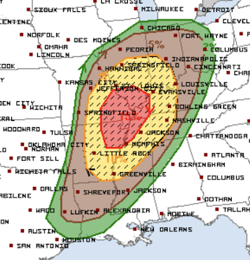
To summarize:
- There is a high risk of tornadoes in the Lower Ohio Valley and Ozarks region
- The hatched areas are where strong tornadoes could occur.
- There is an enhanced risk of tornadoes in the yellow areas.
- There is a significant risk of tornadoes.
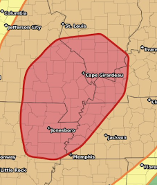
Closeup of the highest risk area.
The first thunderstorms should form 3-4pm over the Ozarks. From there, the storms will become more widespread and more likely to become tornadic. Tornadic thunderstorms will occur throughout the night as the storms move east.
Now is the time to prepare.
- Recommended safety suggestions:
- Start closely monitoring the weather after 4 pm.
- Make sure family and friends are monitoring the weather.
- Make sure you can get family, especially infirm members, to shelter quickly if a tornado warning is issued.
- Do not try to drive to a shelter after a tornado warning is issued. If a tornado watch is issued and strong thunderstorms approach you area, proactively go to your shelter area. Don't wait for a warning if you live in a mobile home or other unsafe building.
- Remember, go to the basement if a tornado warning is issued. If one is not available, then get into a closet or bath in the middle part of your home.
- Insure your shelter area is ready to go. A flashlight, a couple of bottles of water, diapers, radio or TV, and always wear shoes into your shelter.


Comments
Post a Comment