Posts

Showing posts matching the search for Wisconsin

"Sarah For Wisconsin:" Hail is Proof of Global Warming

Image
In a rather unhinged rant -- that has been removed from her Twitter/X feed -- Sarah Godlewsky says that hail in Wisconsin is proof of climate change. While she is outside talking about hail, the tornado sirens are sounding -- she should be in the basement! Fortunately, someone grabbed the rant and you can view it here . Sarah is Secretary of State for Wisconsin. In her rant she says we are "ignoring the environment." We've spent $16 trillion on global warming! And, most of it stupidly! Sarah evidently lives in Madison. The University of Wisconsin with its excellent meteorology department is also based there. I recommend Sarah take its basic meteorology class. In it, she will learn the difference between climate and weather. Wisconsin has always had hail and will always have hail.  In addition, the 1984 Barneveld, WI F-5 tornado was one of the worst in the history of the United States and it occurred at night. Global average temperatures were quite a bit cooler in 1984 (w...

Another Ice Storm Threat for Wisconsin and Michigan

Image
Another period of freezing rain, along with potential power failures, is in store for Wisconsin and Michigan.  As of 5pm EST, there are still 393,000+ homes and businesses are still without power.  This was very well predicted by the Sperry-Piltz Ice Accumulation Index. An excerpt of one of the forecasts that appeared on this blog before the storm is below. Note the prediction of major power outages. The index is usually quite accurate.  Unfortunately, we have a new ice storm risk for Wisconsin and Michigan. Below are the detailed maps. Freezing rain will likely develop in Wisconsin after 1am on Monday.  Freezing rain will likely develop after 6am Monday in Michigan.  The details of the index are below. Click to enlarge.  Utility crews will be strained to restore power if this develops as forecasted. Electrical outages, as a result, may last longer than usual. 

9p Update: Tornado Risk: Iowa, Illinois, and Wisconsin

Image
All tornado warnings have expired as of 9pm. However, the tornado watch for northern Illinois and southern Wisconsin continues until10pm.  ---- The tornado watch continues as of 7:40pm with a tornado warning  in effect in southern Wisconsin.  New Tornado Watch has been issued: -- original posting -- The bright red outline is where there is an enhanced red risk of tornadoes from now until 7pm. Please closely monitor local weather. You may also follow me on Twitter @usweatherexpert. 

Significant Tornado Risk: Minnesota, Iowa and Wisconsin

Image
Mother Nature seems stuck in a rut: tornadoes in Iowa, Minnesota and Wisconsin. I urge people in the area tinted in brown to keep up on the latest weather information as the afternoon and evening progress. 

Damaging Tornado in Southwest Wisconsin

Image
There has been a tornado that has done damage -- extent unknown -- over southwest Wisconsin this evening.  The blue area is where the tornado was strongest which would include from Boscobel to north of Hickory Grove to about five miles east of Hickory Gove. 

The 100th Anniversary of the Cold Front of 11/11/11

Image
Below is the annotated record from the Weather Bureau's Springfield, MO thermograph from November 11, 1911: The temperature reached a high of 80° then dropped 40° almost instantly and continued to drop until it reached 13° at midnight. In many Midwest and Plains cities, the record high and low on November 11th both occurred on the same day one hundred years ago. According to the National Weather Service, the front didn't just bring plunging temperatures, Impacts from this amazing cold front included a reported 9 tornadoes in Michigan, Illinois, Indiana, and Wisconsin, widespread dust storms in Oklahoma, extensive thunderstorms with straight line wind damage; all followed by near blizzard conditions behind the front. A reported F4 tornado struck the town of Janesville, Wisconsin killing 9 people, only to have blizzard conditions and near zero degree temperatures to follow hours later. A number of NWS offices have special information about this event.  Just click on...

3rd Day in a Row of Major Tornado/Severe Thunderstorm Threat in Midwest

Image
Today's forecast is fairly complicated, so I'll break it down by element.  Tornado Risk This is my forecast of the tornado risk. The red area has a high  risk of tornadoes. This includes Appleton, Stevens Point, and Wisconsin Dells. The yellow area is an enhanced risk  of tornadoes. The brown areas represent a significant risk. If you live in the southeast half of Wisconsin, it is vital you keep track of the weather the rest of the day! Tornadoes are likely! Damaging Wind Risk This and hail are SPC's forecasts. The hatched area is where wind gusts of 75 mph or stronger are forecast to occur. In other areas, the gusts are forecast to be between 58 and 74 mph. This will cause additional power failures in a region already hard hit (below). This means, with the additional outages, some people will be without power for days. The colors represent the relative probabilities: Red has an enhanced risk  (1/3 chance within 25 mi of a given point) Yellow has a significant risk....

Politics and Climate Science in Georgia

Climatology is the study of long-term weather (known as “climate”) and its effects. Sounds straightforward, right? When I was at the University of Oklahoma studying for my degree in meteorology, climatology was a bit of a weak cousin to meteorology (the study of weather plus forecasting the weather). OU offered only one course in climatology. While I took that course, I thought I needed to know more so, shortly after college, I actually purchased a textbook on applied climatology because I thought I’d use it throughout my career. Turned out I was correct. Climatology is a very useful discipline for making many decisions.   In the 1970's, little did any of us suspect that climatology would end up being the political hot potato it has become today. As Meteorological Musings’ readers know, this is a non-political blog. I dislike politics and climate science has been corrupted by politics and politicians. So, imagine my shock when I learned that my friend, colleague, supe...

Tornado Risk: Wisconsin & Upper Michigan

Image
We have a tornado risk over northern Wisconsin and Upper Michigan later today. Also, the risk of a damaging wind event, large hail and, perhaps, a tornado has increased tomorrow. This includes the Twin Cities.

7:06pm Update --Today's Tornado Risk

Image
Tornado Watch: Minnesota and Wisconsin This watch is in effect until 10pm CDT. In addition to "a couple of tornadoes," hail to 4 inches in diameter and wind gusts of 75 mph are forecast to occur.  --- original posting (still valid) --- There is a risk of tornadoes in the U.S. border area. This is a heavy recreational area.  The brown area of northeast Minnesota and adjacent areas of far northwest Wisconsin have a significant risk of tornadoes beginning in mid-afternoon.  This map is hail risk. Where you see hatching, hail larger than two inches in diameter is forecast to occur. The red area has an enhanced  risk. The yellow area has a significant risk.  If you live in the area, please make sure you monitor the weather in the region. If you know of people camping or boating in the area, please try to get hold of them to insure they monitor the weather. 

Plains - Midwest Winter Storm Update

Image
Lots to talk about. For people wanting to travel by car or air in these regions, let's start with the timing. 6am CST Wednesday Tonight, travel on I-70 and I-40 will be difficult due to heavy snow. It will be snowing in Denver tomorrow morning. A blizzard warning has been issued for much of western Kansas. 6pm CST Wednesday Most all of this north of a Dodge City to St. Joseph, MO line is snow. It will be snowing hard on I-80 and I-29 in eastern Nebraska and southwest Iowa by this time. Winds are forecast to gust into the 35-50 mph range creating blizzard conditions. 6am CST Thursday Just about everything north of I-70 is snow. A blizzard will be in progress in Iowa, NW Illinois that will move into southern Wisconsin with considerable drifting snow.  From the Ozarks, south, strong thunderstorms will be in progress. Tornadoes in the nighttime hours Wednesday night and Thursday morning cannot be ruled out. 6pm CST Thursday Powerful storm with a textbook shape has ...

Tornado Warnings: Wisconsin, Iowa, West of Chicago

Image
West of Chicago, strong tornado indication. Storm moving E to ENE. This storm is headed in the general direction of Aurora. In Iowa, two tornado warnings. Storms moving E to ESE.  4:31pm  tornado confirmed near Belmond, IA. Take cover with all of these storms! Tornado still moving toward or just north of Cassville, crossing Mississippi into Wisconsin at 4:31pm.

Weather Threat in Wisconsin, Iowa and Illinois

Image
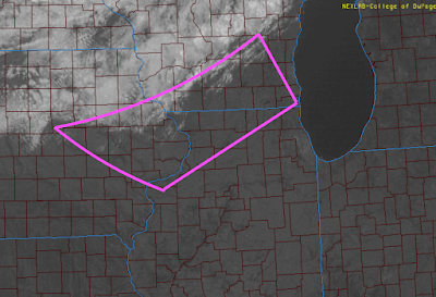
If you or friends or family live in the pink area, you may want to keep an eye on the weather as things evolve this afternoon and evening. I think severe thunderstorms are a pretty good bet and tornadoes are also possible. Tornado watch just issued for part of this area: Severe thunderstorm watch in southern Wisconsin:

Today's Tornado Forecast, Updated 7:30pm CDT

Image
7:30pm CDT. Tornado watch just issued. Again, no additional weather coverage tonight.  7:25pm A tornado watch will likely be issued for much of Lower Michigan and northern Indiana. However,  this will be my last storm update for the night.  I will update the major wind and tornado threat for Friday in the morning.  5:20pm New tornado watch for northern Illinois, including Chicago and northwest Indiana, until 10pm. The dark red areas = tornado watches. Bright red = tornado warnings (take cover!). 4:15pm. Tornado Watch for much of Wisconsin and far northern Illinois.  1:15pom. The first tornado watch of the day has been issued.  This includes the Twin Cities. Please keep up on the weather in these areas.  -- original posting, still valid-- Today Begins a Multi-Day Tornado Risk Across the U.S. East of the Rockies The yellow, hatched area is where there is an enhanced  risk of strong tornadoes. This includes Chicago, Milwaukee and Madison. The brown ...

Wisconsin Storm Damage

There was tornado damage in several parts of Wisconsin yesterday (see radar coverage below). Details here .

Why You Need StormWarn!

Image
There has just been a regional tornado outbreak in southeast Wisconsin less than two hours after a forecast of "no tornadoes" was issued by the National Weather Service.  The above forecast was issued by the NWS's Storm Prediction Center at 11:48am. The green area has a 2% risk of tornadoes. Elsewhere, the forecast was for no risk.  However, less than an hour later, a regional outbreak of tornadoes began in southeast Wisconsin.  Each of the red triangles represents the location of a tornado.  Tornadoes can be tricky to forecast. My purpose is not to criticize the National Weather Service. My goal is to illustrate why you need a tool -- StormWarn -- that will inform you that you are in danger when you are in the path of a tornado or damaging thunderstorm warnings of 80 mph or more.  StormWarn will ring your phones when you are in the direct path of a tornado even if you are asleep in the middle of the night. The great thing is it will not  warn you un...

24-Hour Central U.S. Rainfall

Image
Flooding in Omaha an Wisconsin; Needed Rain Elsewhere Moderate flooding is forecast for the Kickapoo River at Viola, Wisconsin, plus there was quite a bit of lowland flooding. There was also flooding along the Platte River Valley of eastern Nebraska and flooding in downtown Omaha . Amounts exceeded four inches in several areas.  Elsewhere, especially Kansas and Iowa, the rain was badly needed. You can refer back to the latest Palmer Drought Index which displayed conditions prior to the rains, here . 

Derecho Developing Early?

Image
UPDATE: 9:28PM. We are now receiving reports of measured  wind gusts of 70 mph in central Iowa. At 9:26 pm the thunderstorms are rapidly intensifying. People in the path of these storms need to be prepared for very high winds. Here is a new severe thunderstorm watch ahead of this line. ORIGINAL POSTING: I'm not liking the look of the thunderstorms developing over Iowa. First of all, the values of "downdraft CAPE" (don't ask) are extremely  high. If the storms fully develop, these values support gusts above 70 mph. Second, organized thunderstorms are already developing AccuWeather regional radar shows these as of 9:55pm CDT Severe thunderstorm warnings are in effect for high winds and hail in central Iowa. Maroon = severe thunderstorm watch. These storms will likely roll across Iowa during the night and may reach into southern Wisconsin and northern Illinois after midnight.

Storm Overview: 8:18pm

Image
Here is a summary. The amber-shaded counties in southern Oklahoma are severe thunderstorm warnings for large hail and damaging winds. Orange-shaed counties are under a blizzard warning. Pink = winter storm warning. Light brown is the high wind warning for the southern High Plains. The tornado watch is yellow on this map. Blues are various winter weather advisories. AccuWeather Regional Radar at 8:08pm shows the storm in its mature stage. Thunderstorms have been developing rapidly south of I-35 in Kansas the last half-hour. Heavy snow is now moving into northwesternmost Illinois and far southwest Wisconsin. Thunderstorms are heading for the Metroplex and severe thunderstorms are in southeast Oklahoma at 8:08pm. Finally, a close up of the severe thunderstorms in southeast Oklahoma shows them moving rapidly northeast at 8:17pm. It has been a very long day. This will be the last update of the night. Please monitor the weather if you are in the tornado watch area!