Posts

Yes, Forecasting Is Difficult

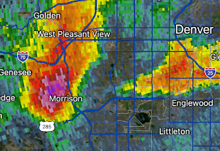
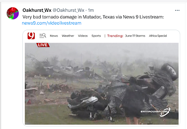
I was mildly amused by this article complaining about inaccurate forecasts pertaining to the economy, inflation and COVID. As you will realize meteorological forecasts are much more accurate than those. While weather forecasting is assisted by the laws of physics, the fact is that weather and storm forecasting is incredibly difficult. There are times the computer models, which rely on those physical laws, are completely wrong. An example would be the Wednesday night storms in Houston .  That is why it is essential that well-trained, human meteorologists remain the ultimate decision makers. 

Tornado Hits South Denver

Image
The blue and white area of south Denver Metro (click to enlarge) is where the tornado occurred. There are uprooted trees throughout the area. I don't know if there is damage worse than that or injuries.  UPDATE: The tornado has been rated EF-1. Update: Here is a more detailed path estimate.  Update: This type of damage is very common, along with blown over fences. There are scattered reports of other types of damage but they do not appear to be widespread. Also, there was large hail. Remember, the NWS's/Univ of Okla scale is in millimeters. 

More on the Last Night's Hail Horror at Red Rocks

Image
Last night's radar at 10:23pm  as hail up to tennis ball size pelted Red Rocks Here is a list of the weather conditions pertinent to the hail horror at Red Rocks Amphitheater last night.  It is questionable that things were not stopped when lightning first arrived in the area. Having personally worked with dozens of venues across the USA, the failure to cancel the evening instantly when the severe thunderstorm warning was issued at 9:04pm, is confounding.  One would think the venue industry would have learned its lesson in 2012 with the Indianapolis State Fair stage collapse and resulting deaths in injuries (including lifetime paralysis).  In my work with venues, I found some attorneys have advised their clients to "play dumb" when adverse weather approaches. Their theory is that, if the venue does nothing, whatever occurs is then an "Act of God." I'm no attorney, but as a forensic meteorologist, I doubt that would play in court in 2023.  BTW: Hail fell at ...

Today's Tornado and Hail Risk

Image
The area where there is a significant chance of tornadoes and damaging winds is in the northeast corner of New Mexico and the westernmost counties of the Texas Panhandle.  Unfortunately, this is another day with a giant hail (hatched) risk along the Front Range, including Denver. Last night, a hailstorm struck the Red Rocks Amphitheater west of Denver. People were hospitalized with broken bones and other injuries. Based on the information available at this time, they venue waited too long to stop the show with highly unfortunate results.  One would think that after the Indianapolis Stage Collapse that venues would stop "playing dumb" when it comes to weather. 

I Used to Be a Road Warrior...

Image
...thank goodness those days are past. 

Immense Suffering in Texas

Image
The town of Matador, TX was hit hard by a tornado earlier this evening.  There are reports of at least one fatality and many injuries but those are unconfirmed. Power is out (see below) in many areas. Update: Four people were killed. The Houston Metro has been walloped by damaging winds this evening.  The Doppler wind measurement (right) was measuring 100+mph winds about 3,000 feet above the ground. Unfortunately, they descended and Houston's Intercontinental Airport clocked a gust of 97 mph (METAR report below). There are reports of aircraft overturned at Hooks Airport northwest of downtown.  In addition to all of the damage, more than a million people  ("customers" = buildings) are without power. With the record heat forecasted again tomorrow, the human suffering is going to be immense.  This is especially bad because Tulsa, northeast Oklahoma, Arkansas and Mississippi still have people without power from Saturday's  derecho. There are people in Tulsa all...

Tornado + Derecho/Damaging Wind Forecast

Image
A second tornado watch has been issued for this area.  Please monitor local weather information if you live in this area.  ----------- A Tornado Watch is Now in Effect Part of the Southern High Plains This is a really difficult, but highly important, forecast.  The NWS SPC forecast that this will be the area of initial thunderstorm development, probably around 4 or 4:30pm.  When the storms develop, they may produce large or giant hail (4" forecasted) or even tornadoes. It important to start monitoring local weather information around that time.  Here's the problem: the models are showing two different paths of the derecho (a long-lived swath of damaging winds) that is forecast to develop from the initial thunderstorms in the red area above. And, a second  derecho is forecast to develop late tonight in Colorado.  Some of the models are forecasting wind gusts of 90 mph or stronger  with these storms. Saturday night's derecho caused more than 1 milli...