Posts

Note to Readers....

I'm working on a report of the events of the last 24 hours.  In the meantime, the national media reports there was "no warning" is absolute nonsense. You can see my coverage at Twitter @usweatherexpert. 

Please Consider Signing Up for StormWarn

I've sat here forecasting and warning of tornadoes almost continuously since 2:30pm Friday. While I am tired, my main emotion is sadness: that people have evidently died in tonight's tornadoes. Nighttime tornadoes are deadly! Please: it is still early in tornado season.  Consider signing up for StormWarn , the 24/7 tornado alarm. It only rings your phone if your home is in the path of a tornado or  ≥ 80 mph winds. Unlike weather radios and other devices, it does not awaken you for hail or storms of lesser intensity.  I receive nothing from StormWarn. I developed it because I believe in it. No more need to stay up into the night worrying about a damaging storm. StormWarn has got your back. 

Strong Tornado in Mississippi

Image
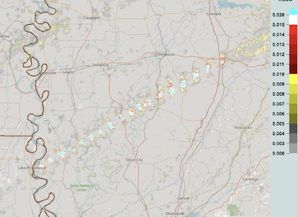
The blue rectangles are centers of rotation of a strong tornado that carved an 80+ mile path across Mississippi.  Rolling Fork and Silver City were both hard hit with reported injuries. The tornado circulation went over Winona but I have not seen confirmed damage reports, as yet.  The power outage figures are homes and businesses. About 70,000 people are without power as of 10:40pm.  UPDATE AT 12:10AM The tornado that began along the Mississippi River west of Jackson reintensified in northeast Mississippi. Its path, in solid blue, is below. It weakened shortly after crossing into Alabama.  There is a more northern path that affected the Oxford area, crossed into Alabama, and caused a tornado that went past Muscle Shoals. The path does not appear to be continuous. There is video of the tornado in the area.   Update: 1:10am This will be my last report for the night. I'll have more later today (Saturday).

3pm Updated Tornado and Damaging Wind Forecast

Image
  The above is the updated as of 3pm  tornado forecast from the NWS SPC. While this forecast is in effect from now until 7am Saturday, the threat for tornadoes probably will not start until 1-2 pm. This is earlier than earlier thought. Based on very late data coming in as I'm typing this, I might extend the red area to Jackson, Tennessee. The color codes : Red + hatched =  high  risk of strong tornadoes. A strong tornado is defined as a "2" or stronger on the EF tornado damage intensity scale. Yellow + hatched =  enhanced  risk of strong tornadoes. Brown = significant risk of tornadoes How to Prepare. Because of the likelihood of power failures (see wind discussion below), the preparations are important. Prepare to care for infirm friends and relatives now. Don't wait until the storms are approaching.  There is a significant risk of power failures. It won't hurt to get a few extra bucks at the ATM. Put your car in the garage along with any lawn fu...

Updated Tornado Forecast for This Afternoon and Tonight

Image
Updated Forecast on the Blog. Scroll Up. The above is the tornado forecast from the NWS SPC. While this forecast is in effect from now until 7am Saturday, the threat for tornadoes probably will not start until 1-2 pm. This is earlier than earlier thought. Based on very late data coming in as I'm typing this, I might extend the red area to Jackson, Tennessee. The color codes : Red + hatched =  high  risk of strong tornadoes. A strong tornado is defined as a "2" or stronger on the EF tornado damage intensity scale. Yellow + hatched =  enhanced  risk of strong tornadoes. Brown = significant risk of tornadoes How to Prepare. Because of the likelihood of power failures (see wind discussion below), the preparations are important. Prepare to care for infirm friends and relatives now. Don't wait until the storms are approaching.  There is a significant risk of power failures. It won't hurt to get a few extra bucks at the ATM. Put your car in the garage along with a...

Late Night Storm Update

Image
First of all, there is a serious risk of flash flooding from 7a Friday to 7a Saturday in the red area. As to the tornado risk, it will be high tomorrow in the red area. Below is the forecast I posted at midday today. The only change I would make to tomorrow's outlook at this point is that I would bring the red area north to include Memphis and to I-40 in Arkansas east of Forrest City.  Please check back with me in the mid- to late morning as I think tomorrow may turn into a dangerous tornado day after about 3 to 4pm. 

I'm Surprised it Took This Long

Image
Given that Greta Thunberg was just given an honorary degree in theology   in Great Britain, I'd say "religious" is the correct adjective.  The tornado was "caused" by a supercell thunderstorm with instability and turning in the lower atmospheric winds. It was the same general set of circumstances that cause tornadic thunderstorms in the Great Plains but a little weaker. As explained yesterday , tornadoes are not uncommon in the Los Angeles Basin during El Nino conditions.  I also think it is amusing that it was the politics  editor who had the story published.  Dr. Roger Pielke, Jr. published a piece earlier today explaining that disasters are not  getting worse with a warmer world . Of the 54 peer-reviewed papers on that topic, 53 agree with that conclusion.  Global warming has clearly crossed into a combination of religion + politics + giant money = worse combination of all .