Posts

Showing posts with the label tropical storm forecast

Hurricane Watch for Tropical Storm Edouard - 11pm Monday

Image
However, the storm is forecast to reach tropical storm force ("S") before it crosses the coast. It will weaken back to a tropical depression ("D") before it reaches Dallas.  The small pink area is where a hurricane watch is in effect. The blue = tropical storm warning. Here is a forecast of rainfall amounts. Fortunately, the heaviest rain is forecast to miss the Hill Country where so much flood suffering has occurred the past 18 months. 

Tropical Storm Bertha Update

Image
S  = tropical storm.   D  = tropical depression. Amber is the radius of tropical storm force winds (40 mph or stronger).  The Hurricane Center is moved its forecast for Bertha back into southern Texas. I'm concerned about heavy rain potential if it stalls in that area.  Otherwise, this is a disorganized tropical storm with 50 mph winds. It is forecast to weaken from this point, onward. 

Tropical Storm Bertha Update

Image
This is the latest update pertaining to Tropical Storm Bertha. It has peak winds of 60 mph (amber area) mostly south of its center (the X ). The forecast path has been shifted a bit to the north. Hurricane development is not  expected. 

Possible Tropical Storm in Northwest Gulf

Image
In addition to extensive flooding, we now have a chance of a tropical storm. Peak sustained winds are forecast to be around 40 mph. Yellow is a tropical storm watch.  In addition, here is the latest on the flooding as of 10:35am CDT. Maroon = flash flood warning. Green = flash flood watch. Bright green = flood warning. 

Area of Concern Regarding Potential Imelda; Updated With Hurricane Center Forecast

Image
Satellite image from 4pm EDT. Humberto with 90 mph is the well-defined hurricane, with an eye, in the right part of the image. The messy cloudiness from Cuba into the Turks and Cacaos is what is expected to form into Imelda.  We have an exceptionally complex meteorological situation because of the two tropical systems potentially interacting with each other. However, since we have the potential for Imelda to form, it appears the most likely area to be affected is outlined in red, below. Two models are showing Imelda getting into coastal areas and then slowing down or even stalling. IF  this occurs -- hardly a sure thing -- there will be heavy to torrential rains and flooding over part  of this area. Near the coast there will be power outages. Dangerous surf will occur because of both storms.  So, I suggest that if you are in the red area you make preliminary precautions for high winds near the coast and potential heavy rains and flooding inland.  Of course, I wi...

70% Chance of Tropical Depression Development

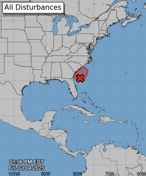
Image
There is a 70% chance of tropical depression or storm development in the next 48 hours in the area outlined in red. Please monitor the weather along the Georgia and South Carolina coasts through the holiday weekend. 

Weekend Tropical Storm Risk: Heads Up in the Southeast

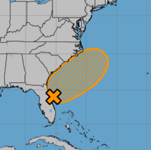
Image
The National Hurricane Center says there is a 60% chance of at least tropical depression development off the Southeast coast over the next seven days.  Especially if you are traveling, it would be a good idea to keep up the forecast the next few days.  Of course, I will provide periodic updates. 

Heads Up, Florida!!

Image
I believe the heavy rain and potential flooding threat is high.  Seven inches or more of rain may fall in a few areas of Florida. Please monitor the weather this weekend.