Posts

Showing posts with the label travel

Avoid the Hassle: These Airports Do NOT Have TSA Screening

With the airport screening situation getting worse by the day, here is a list of airports that have private sector -- rather than TSA -- screening.  Example: Rather than dealing with the reportedly huge hassles at Philadelphia, leave from Atlantic City. Zero delay because they do not have the TSA (they use private security) and are operating normally.  Atlantic City International Airport (New Jersey) Charles M. Schulz—Sonoma County Airport (California) Dawson Community Airport (Montana) Great Falls International Airport (Montana) Glacier Park International Airport (Montana) Greater Rochester International Airport (New York) Havre City-County Airport (Montana) Kansas City International Airport (Missouri) L. M. Clayton Airport (Montana) Orlando Sanford International Airport (Florida) Portsmouth International Airport (New Hampshire) Punta Gorda Airport (Florida) Roswell International Air Center (New Mexico) San Francisco International Airport (California) Sarasota-Bradenton Inter...

Update (10:20p CST) Pertaining to the Major Winter Storm

Image
Radar Image and Commentary as of 10pm (This is the last of the hourly updates for this evening.) Radar image from 10pm. Note the explosion of pink/salmon color from southeast Oklahoma across southern Arkansas. The following (blue) was written at 9p: I am increasingly concerned about more freezing rain over the southeast half of Arkansas than is currently being forecast. If you live in southeast Arkansas, I recommend making ice storm preparations now.  Radar, plus ground truth data from Arkansas weather stations, show the icing concern is well-founded. There will be icing during the night in at least part of this area. 10:20pm Note: Some of the weather station's wind measuring instruments have already glazed over in southern Arkansas.  Thunderstorms with snow/sleet/freezing rain may occur in OK, AR, TX south of I-40. Ice Storm Warnings in Violet  Violet = ice storm warning (rare) Pink = winter storm warning  Purple = winter weather advisory  Dark Turquoise = wint...

Midwest Blizzard Warning - Updated 6:55pm

Image
Can't believe we are forecasting a blizzard again but here we go. The blizzard will affect Interstates 70, 80, 29, 90 and 35. I strong recommend not traveling (we lost ~20 people in multi-car accidents this past Friday) unless it is a genuine emergency. Snow amounts in parts of north central Kansas and south central Nebraska will exceed 6 inches in places.  The color code: Orange = blizzard warning Gold = high wind warning Maroon = red flag warning (wildfire conditions) Pink = winter storm warning  Dark blue = winter storm watch Purple = winter weather advisory  Brown = high wind watch I believe that blizzard or near blizzard conditions will occur even farther to the southeast, at least as far southeast as Manhattan and Salina and -- perhaps -- Hutchinson in Kansas.  Radar forecast (snow = blue with the heavier rate of snowfall darker blue) for 8am Wednesday. 

Heavy Snow West; Heavy Rain Mid-South

Image
More than five inches of rain (orange) is expected to fall in parts of the Mid-South region. Some flooding is likely.  Outside of the West snow will be widespread. Here is a general idea of where at least 2" of snow will fall between 6am Sunday and 6am Friday. Some areas will have heavy  snow but it is too soon to pin those down.  In California, as much as 90" of snow are forecast to fall in the Sierra between tonight and 6pm next Saturday. There will be times I-80 across the mountains will be closed. 

Updated Winter Storm Forecast, 9:30pm CST

Image
--- This Forecast Has Been Updated  --- You Will Find the New Forecast Here After a quick look at the new data this evening, I believe the forecast is still good. There may be light amounts of freezing rain in north central Texas as far south as Waco. It will not be enough to cause power outages but -- if it occurs -- it will make roads very slick.  The snow amount forecasts haven't changed. I believe DFW will receive 1-3" with heavier amounts as you go northeast. I-30 will become a mess for its entire route.  --- original forecast still valid --- Here are the latest NWS winter weather warnings and watches as of 3:15pm Note: the white "hole" in southwest Texas will be filled in with a purple winter weather advisory for 1-3 inches of snow.  Color codes: Pink = winter storm warning  Dark green = winter storm watch Purple = winter weather advisory  Bright green = ongoing flood warning  Dark blue and bright turquoise = freeze warnings.  As expected, t...

Major Winter Storm This Weekend

Image
12:35pm Update: While this forecast is still valid,  there is a newer forecast here . A major winter storm is likely in the central U.S. this weekend. Here are some details.  Please take this into account if you are going to travel this weekend. 6am Saturday to 6am Sunday This storm will be moving from northwest to southeast. Most all of this precipitation will be in the form of snow with some sleet possible in Missouri. Not shown on the map is the potential for some freezing rain developing in Kansas Saturday night. 6am Sunday to 6am Monday I have modified this map to pull the potential for freezing rain and/or moderate to heavy snow farther south into Kansas and northern Oklahoma. Some sleet or freezing rain is possible over the southwest third of Missouri. In the rest of the area, moderate to heavy snow is likely.  This storm has the potential to significantly disrupt airline travel at Chicago and, possibly, Detroit.  Below are forecast temperatures (not wind chil...

Two Areas of Potential Flooding This Week

Image
There is a poorly defined area of low pressure center near Yucatan that is finally showing signs of becoming better organized. It is below as of 1:15pm. The best indications at this point are that the low will drift northwest and become better organized over the next 3-4 days. There is a 70% chance it will at lease become a tropical depression. It might become Tropical Storm Alberto but that is unclear at this point. What does seem clear is that the western Gulf Coast will be drenched.  The low pressure center's location above is the forecast from the ECMWF model for 6am Wednesday. The rain represents where heavy rain is forecast to occur (it does not show light rain in this particular presentation).  Below is the 7-day rainfall amount forecast.  The amber area along the Texas Gulf Coast is where 7-10 inches of rain are forecast to fall. Over the north central states, multiple waves of low pressure are forecast to move over the region during the next seven days. The overa...

Sunday Fun: World's Smallest Commercial Airport -- Been There, Done That

Image
On the Caribbean Island of Saba is the world's smallest commercial airport along with the world's shortest commercial runway. An article about it is at the link. The island is gorgeous and the people are friendly. You are likely to see a wild monkey when you are there. If you are visiting the Island of St. Martin or one of the other nearby islands, it is well worth the side trip. 

Huge Northern Plains and Upper Midwest Snow Storm - Updated 4pm

Image
Please use these forecasts for planning travel! If you are planning to change planes in Minneapolis (Delta Airlines' hub), you may wish to see if they will route you through their hubs in Detroit or another city. While the Minneapolis airport usually does a fine job with snow, this storm is going to test their abilities.  Late data indicates winds may be a bit higher than originally forecast, meaning there will be some drifting of the snow.  Here is the forecast snow to 7pm Monday.  More snow is forecast to fall after that time. The map below is the probability of 4" or more of additional snow until 7am Tuesday.  Below Are Forecast Radar Images The blue represents falling snow, with the darker colors representing heavier snow. This is for 7am Sunday.  7pm Sunday radar. 

Today's Midwest Snow Storm - Updated 2:50pm

Image
As of 2:50pm CDT, snow continues to roll across the Upper Midwest.  Below is a forecast of additional  snow with this storm. The huge Maine storm we forecast is hours away. Please prepare accordingly. 

Winter Storm Outlook -- Updated 4:45pm

Image
It is looking like a winter storm will be developing over the northern Great Plains over the weekend.  Sunday and Sunday Night At lower left is the probability of 4" or more of snow. It is also possible there will be strong winds with this storm. So, I recommend those traveling on I-90 and, especially, I-94 begin looking at alternate routes. Note also the high probability of heavy snow over the Sierra.  Monday and Monday Night With Monday's snow, preliminarily, amounts may be high over parts of Minnesota and the eastern Dakotas. Again, consider the possibility of re-routing a road trip. If you are planning to fly through Minneapolis, you may wish to consider a re-route through Northwest's Detroit hub, if possible.  Update 4:45pm: The National Weather Service is also raising the alarm . 

The Questions Meteorologists Ask: "Why Weren't The Warnings Heeded"?

Image
Forecasts of "extreme snow" went out on February 26 and continued with NWS blizzard warnings three days  before the storm began. Yet, in spite of all of the warnings.... The snow amounts have indeed been extreme: Meteorologists measuring snow depths..

Attention: Interstate 40 Travelers - UPDATED 10:35pm

Image
Interstate 70 is closed westbound at Williams. -- original posting --  The California storm is moving east and the snow has begun in Flagstaff, AZ. This screen capture was done at 7:48pm MST. The forecast is for 16 to 25 inches of snow with the recent model data indicating the upper half of that range may be more likely. Even though Arizona's DoT does a pretty good job with snow removal, that is a lot for any organization. So, please have a contingency plan if the highway is closed. 

At Least Eleven Days of Heavy Rains

Image
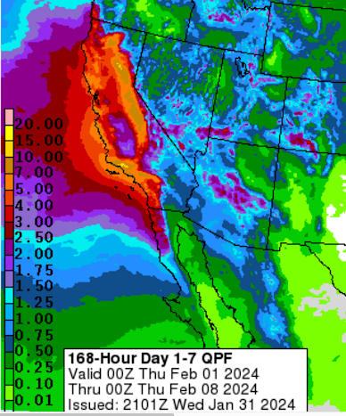
8:30pm PST:   I've taken a quick look at the latest model information and it does nothing to assuage my concerns. This has the possibility  of storms of the intensity of those during the winter of 1982-83. Preparations are needed in the Southland. I'll have more tomorrow.  I continue to be quite concerned about the likelihood of flooding in California.  The map below depicts rainfall the next seven days. Note there are multiple areas where ten inches or more (yellow) are forecast to fall. For Southern California, this may be the most serious rainstorm (with possible thunderstorms and/or flash flooding) in a number of years.   The first of several weather systems is now affecting the northern two-thirds of the state currently. The radar is below. This evening and tonight, some flash flooding may occur in and near the coastal mountains from the Oregon Border to Vandenberg AFB. Radar at 2:10pm PST The most powerful of the storms will strike over the weekend, making...

11:10pm Freezing Rain Update

Image
Ice Storm Warning Extended into the Missouri Ozarks National Weather Service warnings as of 10:53pm.  Color codes: Deep purple = ice storm warning. Pink = winter storm warning for ice (lesser threat than the deep purple). Purple = winter weather advisory for freezing rain or freezing drizzle (lesser condition). Green = freezing fog (slippery roads may develop). Gray = fog advisory Ignore the pale tan. An ice storm warning not only means that roads will be nearly impassible but that there is a chance of power outages.  11:15pm: the Oklahoma City airport is closed due to icing. Flights are being diverted to other airports.  Regional Radar at 11:10pm. The precipitation is moving northeast. The heaviest freezing rain is the darker salmon color from the southern Flint Hills of Kansas into eastern Oklahoma. Conditions will deteriorate rapidly in the Missouri and Arkansas Ozarks the next three hours.  Here is a forecast of freezing rain from 9pm this evening until 1pm Monda...