
3:15pm: Gulf Hurricane Outlook
If I were a resident of the area from Beaumont-Pt Arthur to SW Mississippi, I would be making plans to leave. My instinct is that Hurricane Ida could be a bad one. Recommendations below.

A bit of information about the forecast above.

Since the Hurricane Center released its forecast (top), the American Global Forecast System has released its ensemble tracks. It is very similar to the Hurricane Center's forecast.
Below is the ensemble tracks from the morning model runs. Please don't put any particular weight on any of the lines.

Below is the ensemble from the overnight model runs.

For three days out, this is a high level of model confidence.

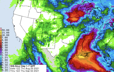
Hurricane "Ida" will likely cause flooding when it moves inland.

What would I do now if I were in this area?


- Contact infirm friends or family in the region. Come up with a plan to protect them should they be placed in a hurricane warning (~24 hr before landfall). This especially applies if an evacuation is ordered. Don't wait until the last minute when rooms may all be reserved!
- Make a hotel reservation well inland. However, make sure you can cancel it at no charge. If it turns out you don't need the room, be courteous the cancel the reservation. This way, you'll have a nice place to stay, if needed. It also frees up the shelters for people who cannot afford hotels. Because of the flooding threat, I might recommend Sheveport or even Dallas.
- Figure out what you can fit in your car in the way of irreplaceable items like scrapbooks and family heirlooms.
- Make sure you have at least three ways of receiving vital warning information.
- Prepare for power failures. If you have a generator, fill it with fuel. Do the same for your car. If you want a generator, have a professional install it.
- Get extra cash at the ATM. Credit cards don't work if the power fails.
- If you have a chain saw, fill it with fuel.


That's it for now. I will update on this situation as things progress. Please make your friends aware of my blog along with my Twitter account @usweatherexpert.


Comments
Post a Comment