Posts

Showing posts with the label tropics

After All of the Absurd Hype Last Week

Image
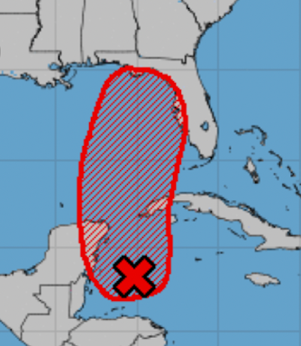
Following up on yesterday's blog posting ...... Phil, with Colorado State U, is one of the foremost hurricane forecast experts in the United States.  Above from  Washington Post  last week. The X  (below) denotes an "area of disorganized thunderstorms" the National Hurricane Center (NHC) has followed, starting early last week, almost all the way across the Atlantic. It was the basis of The Weather Channel's and innumerable bloggers' hype.  Now, there is -- at most -- a 20% chance of a tropical depression (below a tropical storm or hurricane in significance) before it runs into mainland Mexico.  I don't think NHC can escape some of the blame for the hype. We don't have any consistent  skill at forecasting hurricanes 7 days and farther into the future. I don't see the need for 10+ days of "a 40% of a tropical depresssion" forecasts all the two-thirds of the way across the Atlantic.  We will never hesitate to bring a genuine threat to your atten...

2024 Hurricane Season, So Far

Image
At this point, the 2024 hurricane season is nothing special,  even with Hurricane Ernesto in progress.  This is quite a contrast to the 2024 hurricane season forecasts. A small sample is below.  Many were mentioning climate change as a reason for the much above normal hurricane season we were forecast to have. What's Next?? Looking ahead to the end of hurricane season, Dr. Sam Lillo created a graph of hurricane statistics brought to my attention yesterday by Dr. Roger Pielke, Jr .  August 15 is the vertical line at right and the star? As Roger explains it,  The figure above shows that historically, the median number of storms to occur after August 15th is about 12, the 90th percentile is about 17 storms, with the most being 22. If seasonal forecasts are going to verify, then the Atlantic needs to get busy — which is of course still very possible... According to the National Hurricane Center, other than Ernesto, no storm is forecast to occur in the Atlantic in th...

NO "Vincent"

Image
The National Hurricane Center now believes the low pressure system near Jamaica will not  become a tropical storm. Instead, it will cause rain and occasional gusty winds.  Rainfall Amount Forecast

Florida Update - No Immediate Tropical Threat

Image
Update 6:20pm EST: There are those continuing to post that a tropical storm will affect Florida this week. While I tend to be a conservative forecaster, I just don't see it for the reasons below. Yes, heavy rain is possible (see map) but I don't see a tropical storm. I will continue to monitor the situation and will update should the data indicate, will not hesitate to change my forecast.  ----- original post ---- There has been a lot of chatter on Twitter, primarily among amateur meteorologists, with regard to a tropical system forming this week and affecting Florida and/or the Bahamas.  I would like to reassure my readers that I do not see it.  Here is the forecast rainfall for the next five days. Note the heavy rain forecast for the western Panhandle. As longtime readers know, I do not attempt to forecast tropical storms beyond about five days. While some of the models show low pressure developing in the western Caribbean toward next weekend, that is very speculative....

Forecast for Tropical System Idalia

Image
[please scroll up for more current information] As promised, I want to give my readers a first estimate of how what I believe will be Tropical Storm or Hurricane Idalia will unfold. While it is too soon to get highly specific, I believe the system near Yucatan will begin to more northeast and gradually strengthen the next few days. The center of the system will reach the coast as a tropical storm or hurricane sometime between Tuesday night and Wednesday night.  Stay tuned! Below is the first update on what they are calling 2023's Tropical Depression #10: The Hurricane Center is forecasting Hurricane Idalia  with sustained winds reaching 75 mph by 5pm Monday. Additional strengthening is likely until the storm makes landfall.  This is NHC's forecast track. S = tropical storm. H = hurricane. 

Florida Tropical Weather Update

If you would like to see the Cancun radar update, to here . That is current as of 10:30 EDT. It is the weather system I've been posting about since Wednesday evening.  Below is the latest from the National Hurricane Center. However,  I believe the entire Gulf Coast of Florida, including the Keys, should watch this potential storm! I expect to be able to begin narrowing this down this evening. Please check back in. 

Florida Tropical Storm Outlook

Image
[ Please scroll up for more current information. ] As promised, here is my tropical storm outlook for next week: The above image is this afternoon's outlook from the National Hurricane Center. It calls for an 80% chance of tropical storm development the first half of next week. My only difference is that I would not eliminate the Keys nor the western Florida Panhandle. It is just too uncertain at this point. All of the models I trust are showing tropical development but there is no consensus as yet as to what the path or intensity would be.  The reason I began covering this a couple of days ago is that,  The wind shear over the region is forecast to be light, which can allow for rapid strengthening.  The hot water over Florida you've heard about all summer. It, too, can allow for rapid strengthening.  Given the above, I did not want our readers to be caught off-guard.  What can you do with this information? You can make preliminary preparations. For example, Kat...

National Hurricane Center Now Concerned About Florida Tropical Storm or Hurricane

Image
The National Hurricane Center now says there is a 70% of a tropical storm or hurricane (it would be named Idalia). However, I would extend the area that should closely monitor the weather as the entire Florida Gulf Coast from Key West to Pensacola.  I'll have more on this tomorrow afternoon. 

For My Florida Readers...

I continue to be concerned about the potential for a tropical system to form in the Gulf next week. I will update about this as things progress.  Please expect to see a more detailed forecast about this time tomorrow afternoon. 

To Our Readers Along the Florida Gulf Coast...

... while this is very  preliminary, I recommend keeping an eye on the weather the next few days.  Of course, I will have updates here starting tomorrow afternoon. 

Tropical Storm Warnings for the Windward Islands

Image
I wasn't expecting this already. The yellows indicate a tropical storm warning.  Beyond the first three days, this is a low-confidence forecast. That is a good reason for vacationers in this region during the Independence Day weekend to keep a weather eye out. 

Tropical "Heads Up"

Image
Generally, we don't discuss tropical threats beyond five days into the future. However, with the Independence Day weekend combined with forecasts of the most travel for any holiday weekend, ever, I thought it was worth posting this. This is the five day forecast from the National Hurricane Center. If you are headed to the Caribbean, Cancun, or even south Florida, it will be a good idea to keep a weather eye on local forecasts. 

Nate: Not

Image
Unfortunately, Nate never got far enough to north to be picked up by the wind currents that might have taken it up toward Texas. Now, a newly developing high pressure center will cut Nate off from any chance of easing the drought in Texas.

A Ray of Hope for Texas

Image
The clump of clouds in the southern Gulf is now Tropical Storm Nate. My earlier posting (see below) discussed that potential path of Nate as being toward Louisiana and that may still be the case. However, some of the models and the National Hurricane Center are taking Nate on a more northerly course. That might -- might -- bring some moisture in south and east Texas. However, the storm currently is under very weak steering currents, so this is only educated speculation at this point. Little movement is forecast for Nate for the next day or two.

A Very Troubling Computer Model

Image
If I had to choose a single computer model to use when analyze and forecast tropical storms and hurricanes, it would be the European Consortium for Medium Range Forecasting Model (ECMWF). It is showing the system now in the Bay of Campeche moving north and strongly intensifying. This is the forecast for Monday evening showing either a hurricane or tropical storm south of Louisiana. But, on Thursday, the storm is forecast to have weakened, but has hardly moved. Another hazard: Tropical storm or hurricane indicated by arrow. It is what is now tropical storm #14 (see satellite graphic above). It is too soon to worry about wind speeds or wind location. It is not too soon to be concerned about more heavy rain in the region, given the 15+" that fell with T.S. Lee. It would be wonderful if the storm were to take a more western path and move into Texas. That is not out of the question. But, any path farther east than Texas will result in major problems.

Tropical Outlook

Image
Here is the 7pm CDT updated outlook from the National Hurricane Center. Please let me run down the four weather systems for you: Katia. Not worried about it affecting the U.S. except for rip currents along the East Coast. System #1 in the southern Gulf. Worth watching. System #2 east of Barbados. Probably not a problem. T.D. #14, I think this will bear watching starting this weekend. 

Tornado Risk Today...

Image
...in the Southeast due to the remains of T.S. Lee. There is a tornado watch currently in effect: click to enlarge Note that the probability of tornadoes is "high." The threat is expected to spread east during the day. A 15% probability of tornadoes is relatively high. In fact, anyone in the brown-yellow-red areas should be aware of the latest bulletins if thunderstorms approach.

Update on Tropical Storm Lee

Image
Below is the AccuWeather radar regional radar. I have circled the center of Lee which is just inland over Vermillion Bay, LA moving slowly northeast.  Here is the National Hurricane Center's forecast for Lee's future movement. S = tropical storm and D = tropical depression.   Between 25,000 and 30,000 are without power at the present time.  Here is the 24-hour (note: not storm total) rainfall ending 7am Central time this morning. There are several areas that received more than 10 inches.  Here is the predicted rainfall from now until 8am Eastern Friday morning. So, what do you do to prepare if you are in an area where heavy rain is predicted? Most cities' web sites have flood plain maps for at least the 100-year flood plain. For example, a flood map for Philadelphia is here . If you live in or near a flood plain, please fill your car's tank with gas, and think about what you would need if you have to evacuate. 

Tornado Watch for Tropical Storm Lee

Image
Update: Tornado watch extended until 7am Sunday. This watch may be extended. Probability of small tornadoes is "high." Pay attention to the weather if you live in these areas.

Tornado Threat With Lee

Image
Tornado watch until 10am and I expect this to be extended. As meteorologist Chris Saindon pointed out, there is plenty of wind momentum aloft to cause damaging winds near the ground in addition to the small-size tornadoes likely in this situation. Thanks, Chris!