Posts

Showing posts with the label computer models

Why the National Weather Service Needs to Be Made an Independent Agency

Image
The NOAA/NWS computer modeling used to be #1 in the world. Now, we are distant #4. NOAA is focused on its marine responsibilities and not weather. We would be far better off with the NWS as an independent agency. My recommendations are here . 

Important Note About Online Hurricane Forecasts

Image
You may have seen this image floating around social media about a “May hurricane” that just isn’t going to occur.  The model image posted on social media is from the American GFS model, well known to be merely the 4th best in the world.  The GFS "overforecasts" hurricanes to a huge extent. I sometimes comment that it forecasts "11 of every 2 hurricanes." This image depicts a Cat 3 hurricane near Florida, a near impossibility in the month of May.    Here's the thing:  No other model is forecasting a hurricane, let alone a major hurricane, or anything like it.  That is a sure sign the GFS model has created yet another of its fictional storms.    The world's #1 model, the ECMWF (depicted below), shows very pleasant weather over Florida region at that same time as the GFS is forecasting its "fictioncane." I won't go into the problems with the National Weather Service's modeling as we have talked about that on other occasions.   To rest...

No One Is Cutting the National Weather Service - Updated

Image
Good Friday morning. I have bumped yesterday's post (below) about cuts to the NWS to the top of the blog and am adding the information in blue pertaining to yesterday's cuts. These points are in no order. Please note: if you scroll down, you find that the reference to cuts was in the context of public safety.  No public safety cuts have been made.  I am aware of cuts made to the NWS during the Obama Administration. I have been sounding the alarm about increasingly serious issues in the NWS for 14 years!  Where was everyone who is complaining now when all of this began? Or, is this merely politics to the critics? The USA is $38 trillion  in debt which is going to sink us all unless stopped! Cuts must be made, even to things we like.  No cuts affecting public safety were made yesterday. Yes, provisionary jobs at the tsunami warning centers (TWC) were cut. However, TWCs are a mess. The Pacific tsunami warning center is in Honolulu and the Atlantic center is located...

What Really Happened to Cause the Horrific Maui Wildfire

Image
The point of this nonsense is to proactively deflect criticism of state officials. Report from CNN. The conditions causing the Lahaina Fire, which has taken 99 precious lives, to be so intense were  not  caused by global warming nor were they caused by Hurricane Dora, nor were they caused by invasive grasses.  The cause has been identified as a mountain wave somewhat similar to the mountain wave involved in the 2022 Marshall Fire in the Boulder, Colorado area. Initial high winds blew down a power line which sparked a fire. Per the New York Times'  graphic below, Maui fire officials, perhaps prematurely, declared the fire was "contained." New York Times Then, the mountain wave helped create extreme winds and, for Hawaii, extremely low humidity -- perfect conditions for the fire to spread. Those winds may not have been detected as they should have been because there is no National Weather Service (NWS) weather observing station in west Maui! The analysis identifying t...

Update on the Pre-Christmas Cold Wave

Image
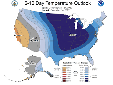
[Note: there is an updated forecast. Scroll up on blog.] Current Forecast This cold wave has the potential to be as cold as the February, 2021, cold wave. If you are going to travel, especially by car, during this period, it is important to make sure you take blankets, water and a power bar (at least) for each occupant in case you should get stuck. It is also a good idea to take some sand, kitty litter, or ice melt so you can sustain yourself if you go off the road due to ice or snow.  I believe the cold air will flow into the north central states on Monday. Here is the temperature forecast noon Monday. Here is the temperature forecast from the Canadian global model valid noon Monday. At 6pm Thursday, the cold wave is arriving along the Texas Gulf Coast and as far east as Ohio. Please note, there  is the likelihood the actual cold air will be colder than what is depicted above. Why? The cold air that flows south from North Pole and Canada gets vertically thinner as it moves so...

Drought: A Small Ray of Hope?

Image
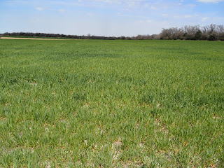
Wheat field, April 16, 2022. central Butler County, Kansas I went out to take a look at a few wheat fields myself this afternoon and the crop probably looks the worst I've seen it in my 40+ years. While I am certainly no expert, the reports of poor crop conditions appear to be correct. Over the next two weeks, the extended range computer models are indicating the possibility that sufficient rains may fall that could slightly ease the drought in the winter wheat belt. How Much Rain is Needed? Based on the Palmer Drought Index, the following amounts are what are needed to ease  the drought. Note: these amounts are in addition  to the "normal" rainfall amount (i.e., if normal is 2 inches and the map shows 3 inches, then 5 inches are needed). NOAA has helpfully calculated the amounts needed. The black areas had insufficient data to make an estimate this week. The states are broken into NOAA's "climate divisions."  The Forecasts Among the products produced by the...

How Did That Cold Wave Forecast Work Out?

Image
You'll recall that on the 4th (Friday), I made a forecast and provided advice pertaining to the cold wave that was going to affect the nation in 6-7+ days. Because I put so much emphasis on the importance of preparation, I thought you would like to see how the forecast worked out.  Here is the forecast: Here are the actual temperatures: Considering this was seven days in advance, I think you'll agree the level of accuracy was remarkable.  This result was a mix of the amazing advances in meteorological modeling combined with some human input. I had four models from which to choose. I spent about a half-hour looking at the models the their recent track record in order to choose the one I thought would yield the best result. 

The Catastrophic Tennessee Flash Flood - Why The United States Needs a National Disaster Review Board

Image
While it is important for meteorologists to make accurate forecasts in situations of “partly cloudy and 70° with light winds,” it is vital to society that weather science provides timely and accurate forecasts and warnings of situations with the potential of considerable loss of life and extreme property damage.    The computer model and human forecasts in the hours leading up to the catastrophic flash flood west of Nashville Saturday morning, where more than 17 inches of rain fell in less than 10 hours, were inadequate. None of the “guidance” prior to the start of the rain signaled that a major event -- which would take at least 21 18 lives with three missing -- was about to occur. The 17 inches (and, up to four additional inches fell later in the day), if confirmed, will shatter the Tennessee's state rainfall record by four inches. So, this is exactly the type of situation where weather science needs to shine.  Below is the actual rainfall amounts for the morning ...

The Forecast That Caused Me to Recognize the Potential of Mesoscale Modeling

Image
 [This posting is primarily for meteorologists and weather aficionados.] Five years ago today, the HAZWX model (a company that was later acquired by AccuWeather) made one of the most amazing forecasts I have ever seen. It caused me to change my opinion as to the potential of mesoscale meteorological modeling. While I had seen some good forecasts, they seemed quite inconsistent. I thought the scale of observations available to feed the models was too course create forecasts at a 4 kilometer scale. This forecast caused that opinion to change.  Major tornado outbreaks are rare in November. A high risk in the High Plains in mid-November would have been unprecedented. The 7am NWS Storm Prediction Center's (SPC) forecast (below) showed an enhanced risk of tornadoes near the border of Oklahoma and the Texas Panhandle with a significant risk (brown) farther north and south.  The HAZWX model, which became available about 11am, forecast something stunningly different: a major outbr...

Forecasts of Regional Climate Change: "Rife With Errors"

While I disagree with the characterization "climate is much more predictable than we previously thought," this article explains that climate attribution studies ("storm X was caused by global warming") are bunk. And, here is an excellent (highly recommended) article on the related topic of ascribing global warming effects on individual storms. If interested, more on this subject, here .

Beware of Computer Modeling Studies

Image
This study was brought to my attention yesterday afternoon. I tend to be skeptical of groundbreaking computer modeling studies, whether good news (above) or bad (more than 2.2 million would die of COVID in the U.S.). So, if you are indoors or in constricted areas outdoors, keep wearing those masks and washing your hands!!

Real Clear Investigations: COVID versus Climate Models

Image
As discussed here several times, the COVID-19 models have been an utter disaster that lead to catastrophic policy choices. Historians will be writing about this for at least a century: how could they have gotten it so wrong? While every COVID death was and will be a tragedy, the United States will not have had 2.2 million deaths when this is all over. This has led to an inevitable comparison between COVID and climate models. This atmospheric scientist will emphatically tell you there are reasons for those concerns. In theory, the climate models should be better because they are more grounded in atmospheric physics than disease models. The latter are new and, while they have uses, they merited nowhere near of a level of trust that we should have shut down the entire economy based on their output. In the hands of un-politicized scientists, they would be. Real Clear Investigations (RCI) has produced an outstanding article comparing the two types of models and I highly recommend it i...

15 Hours of Headlines: Whatever This Is, It Isn't Science

Image
From Drudge  today: Haven't the epidemiology models taken us down this road before? Like, three months ago*? Meanwhile, at the time time as Drudge: And, from NBC News' correspondent Carl Quintanilla, at the same time as the above: Glenn Reynolds accurately describes this fiasco: AND YET POOLS WERE CLOSED EVERYWHERE, WITH NO SCIENCE BEHIND THE DECISION:   ‘No evidence’ COVID-19 can be spread in swimming pools, CDC says. Apparently the only coronavirus countermeasure that can’t be deployed without peer-reviewed, double-blind studies involving thousands is hydroxychloroquine. For everything else it’s just go with your gut and shout “Science!” at anyone who expresses doubts. Other sciences are learning what meteorologists learned a full century ago: Forecasting, with any consistent  accuracy, is extraordinary difficult. It is not accomplished by throwing something at the wall and seeing if it sticks. How will epidemi...

COVID Model Accuracy Update: Terrible

Image
Just five days ago , I wrote about how bad the COVID fatality models have been in Kansas. Since, they are gotten worse...significantly worse. Here is the latest. click to enlarge On the fifth of May, the model predicted 158 fatalities and the actual number was 144. The model was off by 13. Today, the model forecasts 181 deaths and the actual number is 158. The model is off by 23. Both forecasts were well outside of the bottom of the "confidence interval" (tan tinting). Kansas began opening earlier this month. That is likely why the model has accelerated its forecast number of fatalities but the rate of actual fatalities has not increased. These models are making meteorologists look like geniuses. They are completely unsuitable for real-world decision-making.  And, from Twitter this evening: The America of 1968-69 was more religious and less risk adverse than the America of today. Friends of mine, and I, have noted that those most concerned about COVID-19 see...

COVID-19: Death Forecast Has Been Slashed

Image
Sunday, just two days ago, I published a piece comparing the University of Washington's coronavirus model's fatality forecast for the states of Kansas and Alabama . I went back to the model (available here ) today to check a piece of information and was shocked by what I found. The model has been re-run. In just two days, the number of COVID-19 deaths forecast to occur in Kansas has been dropped from 640 to 265 -- a tremendous reduction. I double checked, the model's initial parameters are the same, so it is apples-to-apples. The initial parameters are at the very top of the Kansas display. UW's model projection for Kansas published today With a current death toll of 25 in Kansas, even the forecast of 265 looks questionable. While this is certainly good news in the sense that fewer people than forecast are going to lose their lives, it is demonstrating these models are useless as decision tools.  Why do I say that? Here's where we began : A late-Januar...