Posts

Showing posts with the label Southeast

Weekend Tropical Storm Risk: Heads Up in the Southeast

Image
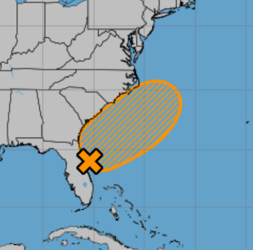
The National Hurricane Center says there is a 60% chance of at least tropical depression development off the Southeast coast over the next seven days.  Especially if you are traveling, it would be a good idea to keep up the forecast the next few days.  Of course, I will provide periodic updates. 

Flooding Likely in the East - Updated 8:30am Sunday

Image
Heavy rains are forecasts for both eastern and western North Carolina, including some of the areas so hard hit by Helene's rainfall in September.   So, I recommend monitoring the weather throughout the Tar Heel State and the other areas where heavy rains are forecast to occur.  -- original forecast -- Flood Forecast More heavy rain is likely in the Southeast which results in a flooding forecast for most of the region. The hatching indicates the flooding is expected the next three days. The cross-hatching indicates the flooding could occur during the next seven days.  A second area of flooding is possible in Upstate New York and New England.  The dots represent the highest stage forecast at various river gauge sites. Orange is minor flooding and red is moderate flooding.  Rainfall Amount Forecast These are the NWS's forecast of rainfall amounts for the next five days. Especially if you live in an area where flooding occurs periodically, please keep an eye on loca...

Comprehensive Update on Tropical Storm Helene; Update 11pm

Image
NHC is now forecasting sustained winds of 120 mph at landfall which would be a strong Cat 3 hurricane. People in Tallahassee should prepare for hurricane force winds.  Next update will be tomorrow morning.  ---- The newest satellite image (6:54pm) shows Helene developing rapidly. This lends credibility to the forecasts and I urge you to follow the safety recommendations.  ----- 5:15pm update below ---- Hurricane Helene is forecast to come into the Florida Panhandle late Thursday with high winds and a major storm surge ahead of the center. Here is a complete update on the storm. Please forward this information to your friends and relatives.  Hurricane Warnings  have been issued for parts of the Gulf Coast of Florida. The central pressure has dropped to 995 millibars (as of 6pm) 992 990 millibars at 8pm and the maximum sustained winds are 50 60 mph. There are also hurricane warnings for Cancun and the northeast Yucatan. The Forecast Path of the Eye of Helene Her...

Important: Flooding Info for the Southeast and Appalachians

Image
This information has been updated.  Please click here for the latest.  ----- At this point, the National Weather Service says, there will be only "isolated flash and urban flooding possible across the Southeast, Southern Appalachians and the Tennessee Valley." I emphatically disagree.  Below is the rainfall forecast for the next seven days.  Yellow is ten inches of rain, amber is seven inches and orange is more than five inches. Given both the amounts and the geographic extent of the rains, I believe there will be moderate to serious flooding in the orange areas. The remains of Helene are forecast to move to the  west  which is why five inches of rain is forecast to fall over the Ozarks Plateau over southern Missouri.  The just received ECMWF model, which usually does a very good job in these situations, is forecasting more than 13 inches of rain in far north Georgia and nearby areas of North Carolina and Tennessee. As much as eight inches of rain is ...

Heads Up: Southeast United States

Image
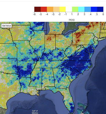
I'm getting increasingly concerned about the potential for major flooding in the Southeast  The Palmer Drought Index (below) shows shows extremely wet conditions from eastern Oklahoma to the Middle Atlantic region.  The computer models are indicating wet and, perhaps, extremely wet conditions over the next two weeks -- and, especially -- February 25 to March 3.  Of course, two week rainfall forecasts can be way off the mark. But, this is a potentially serious situation and I wanted to give my readers a "heads up."