Updated: North Dakota Hard Hit By Derecho and Tornadoes Last Night
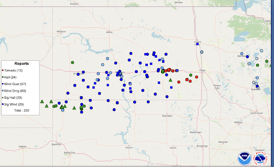
Minnesota and, especially, North Dakota were hard-hit by a derecho and tornadoes yesterday night -- with many of the storms occurring after 10pm. Three have been reported to have died.
The red dots are tornado locations. However, there will be many more locations added as the ground surveys continue. I have plotted only the reports of hail 2" in diameter or larger. The blue dots are wind gusts of 60 mph or stronger. The squares are reports of 75 mph or stronger. There were winds measured all the way up to 101 mph (below). Much stronger winds were recorded in eastern North Dakota and northwest Minnesota after 11pm.
An animation of the radar showing the derecho and supercells is here.
Update 7pm. Some preliminary tornado ratings from last night:
--- the forecast posted here at 8:11am Friday ---
There is an enhanced risk of strong tornadoes in the yellow, hatched area. The brown area has a significant risk of tornadoes. There is also an enhanced risk of damaging thunderstorm-generated winds. Power outages are likely, at least in spots. Please keep up on the latest weather information starting this afternoon.


Comments
Post a Comment