
Posts

Showing posts with the label Northern Great Plains

Important Forecast: Tornadoes With Derecho Forecast Tonight

Image
Tornado Risk There is a significant risk of tornadoes in the brown area.  Derecho Risk For Winds Up to 90 mph The area in yellow has a significant risk of wind gusts of 60 mph or stronger. The red area has an enhanced risk of wind gusts of 60 mph or stronger. The purple area has a high  risk of gusts of 60 mph or stronger. In the hatched area, derecho-generated winds of 90 mph are possible.  A  derecho  is possible. Please keep in mind that wind force is logarithmic which means that an 90 mph gust is far more damaging than a 60 mph gust.  Safety Recommendations If you live in a mobile home or need a public shelter, you will find lists and maps  here . Please check it now, before the threat of a tornado or extreme winds is imminent. If you have friends or family living in housing without an adequate tornado/extreme wind sheltering area, please give them a call and refer them to the public shelter site.  With this combination of tornado and derecho ...
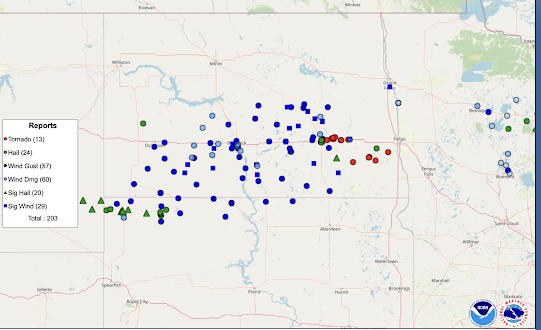
Updated: North Dakota Hard Hit By Derecho and Tornadoes Last Night

Image
Minnesota and, especially, North Dakota were hard-hit by a derecho and tornadoes yesterday night -- with many of the storms occurring after 10pm. Three have been reported to have died.  The red dots are tornado locations. However, there will be many more locations added as the ground surveys continue. I have plotted only the reports of hail 2" in diameter or larger. The blue dots are wind gusts of 60 mph or stronger. The squares are reports of 75 mph or stronger. There were winds measured all the way up to 101 mph (below). Much stronger winds were recorded in eastern North Dakota and northwest Minnesota after 11pm. An animation of the radar showing the derecho and supercells is here.   Update 7pm. Some preliminary tornado ratings from last night: --- the forecast posted here at 8:11am Friday --- There is an enhanced  risk of strong tornadoes in the yellow, hatched area. The brown area has a significant risk of tornadoes. There is also an enhanced risk of damaging thunders...

Today's Tornado and Derecho Risk

Image
Tornado Risk This is more of an all-day risk than usual. There are already thunderstorms developing in central South Dakota.  Derecho Rixk Here is the color code: Yellow has a significant risk of wind gusts of 60 mph or stronger.  Red has an enhanced  risk of wind gusts 60 mph or stronger.  Hatched = wind gusts of 75 mph or stronger.  Prepare for damaging winds.  Bring in law furniture and other items that might be blown about. Put your car in the garage.  If a wind warning for 80 mph or stronger is issued, get indoors and stay away from windows. Mobile homes are not safe in winds of this strength.  Of course, if a tornado warning is issued, go to the basement or take your usual tornado tornado safety measures.  Damaging Wind Risk There is also the potential for 60 mph or stronger winds in the yellow area on the map of New England.  Tree damage is possible along with scattered power outages.