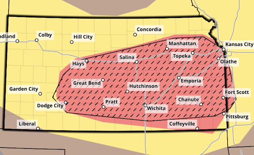
Planning Forecast for Tuesday Afternoon and Night
This forecast has been updated. Please click here for the update.
As of the present time (5:15pm Monday), thunderstorms are developing in Nebraska. Some of those will affect Kansas late tonight and Tuesday morning. There could be some isolated wind gusts to 50 mph. This forecast pertains to the afternoon and night hours from about 4pm Tuesday to 5am Wednesday.
Tornado Risk
The orange area has an enhanced risk of tornadoes. Some could be strong (EF-2 or stronger. The brown area has a significant risk of tornadoes. This risk will begin around 4pm and will increase into the evening.
Damaging Wind Risk
The red, hatched area has an enhanced risk of wind gusts of 75 mph or stronger. The red area without hatching has an enhanced risk of gusts of 60 mph or stronger. The yellow area as a significant risk of 60 mph winds or stronger. In the hatched area, there is a serious risk of destructive storms: tornadoes and damaging winds. Power outages are likely and some could last more than 24 hours. There will be tree damage.
If you live in these areas, please make sure you begin monitoring the weather around mid-afternoon.
Of course, I will update this forecast tomorrow morning.


Comments
Post a Comment