Posts

Extremely Dangerous [Eventual Hurricane] Idalia Headed For Florida

Image
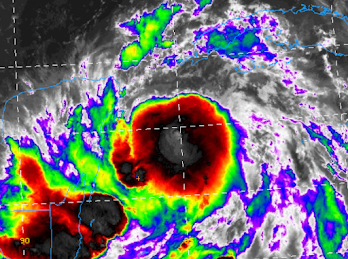
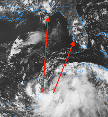
[Scroll up for more current information. Thank you.] There is no doubt in my mind that Idalia will be  a  major hurricane at the time of landfall.  The deep red above is what meteorologists call a "wind swath," which is the highest wind gusts along a hurricane's path. It is too soon to know the exact path but, if you are between the two arrows and you are told to evacuate, DO IT.  There will likely be a devastating storm surge.  There will be a compete update between 11 and 11:20am, after the NHC releases the latest information. 

11:15pm Update on Idalia: Strengthening Continues

Image
[Scroll up for more current information. Thank you.] Hurricane Warning for Western Cuba The wind speed is up to 60 mph (sustained) with a central pressure of 992 millibars.  The storm is more or less stationary but will begin moving north tomorrow morning.  Red is a hurricane warning  for western Cuba.  The entire  pink area (hurricane watch) should realize that hurricane-force winds are possible. There will also be a storm surge over the entire watch area. I continue to believe that there is a more than 50% maximum winds will be 100 mph or stronger. I now also believe there is a 1/3 chance that winds will be 120 mph or stronger.  The rest of the information in the post below is valid.  I'll update again late Monday morning. 

9:40 pm EDT Special Update: Idalia, A Bit Stronger

Image
[Scroll up for more current information. Thank you.] I want to update you before your retire for the night. As of 9:40pm, trends continue in the wrong direction.  The inner core development (immediately below) continues. A nearby buoy is measuring rapidly falling barometric pressure. This strongly implies that strengthening is occurring more quickly than forecast.  Two more ensembles of models have come in and they, too, forecast a path a little farther to the east.  Given the above, it would not surprise me if hurricane warnings for the west coast of Florida and/or western Cuba were issued later this evening. Regardless, it is absolutely essential for those in the hurricane watch and  the caution zone (below) to prepare for the potential  (not certainty) of major hurricane conditions.  [ --- original text, still valid ---] I don't like the trends I am seeing with Idalia. Satellite seems to be showing the storm developing an inner core a bit sooner than exp...

5:20pm Idalia Update

Image
S = tropical storm. H = hurricane. The National Hurricane Center's (NHC) path is within the white "cone." The pink is a hurricane watch and yellow is a tropical storm watch. I continue to caution the entire south extent of the watch area to keep a close eye on the progress of what will very likely become Hurricane Idalia (red arrow).  The new storm surge maps are not available but they should be similar to the one in the posting below. NHC is now forecasting a storm surge up to 11 feet along and just to the east of where the eye makes landfall. Tornadoes will be likely, especially north of Alligator Alley and east of Tallahassee.  Here is the latest rainfall amount forecast.  "The Cone" is an unfortunate name for the area outlining NHC's risk envelope for the path of the eye. An explanation is below.  I would call it, "the zone" but that is just me. Please note that I'm giving some extra leeway on the east side of the "cone."

3:45pm Eastern Update on Likely Hurricane Idalia

Image
[please scroll up for more current information] I believe Idalia will intensify from tropical storm to hurricane status. There is a a better than 50/50 chance the storm will have sustained winds of 100 mph or stronger. The arrows represent the area that will feel the greater effects of the storm. The eye will likely make landfall between the arrows.  I expect a hurricane watch will be issued this afternoon.  The storm surge will be more than three feet with Idalia and, in a worst case, should Idalia become a major hurricane, the surge may be more than 10 feet in places. Please note that a storm surge is forecast for Tampa Bay. Tornadoes will also occur over Florida, especially north of Alligator Alley and east of Tallahassee.  Heavy rain, with the potential for flooding, exist. See below.  I will have more this evening. 

11:45am EDT Update on Developing Hurricane Idalia

Image
[please scroll up for more current information] Update at 11:45am: We now have Tropical Storm Idalia Well, that was fast. The Hurricane Hunters show the tropical depression has strengthened into Tropical Storm Idalia.  --- Original Text --- Here is the latest from the National Hurricane Center from their 11am advisory Idalia (pronounced,  ee-DAL-ya). S = tropical storm. H = hurricane I have added a "caution" area between their "cone" (the white shading) and the southwest Florida Gulf coast. It would not at all surprise me to see the storm take a path a little more to the east than currently indicated.  There is a Hurricane Hunter aircraft in the storm at this time. It is gathering data for the 1pm model run and I would expect more precise info on the path and intensity to be available when those models' output is available early this evening.  I'll also provide additional information pertaining to hurricane preparation measures later this afternoon. 

Forecast for Tropical System Idalia

Image
[please scroll up for more current information] As promised, I want to give my readers a first estimate of how what I believe will be Tropical Storm or Hurricane Idalia will unfold. While it is too soon to get highly specific, I believe the system near Yucatan will begin to more northeast and gradually strengthen the next few days. The center of the system will reach the coast as a tropical storm or hurricane sometime between Tuesday night and Wednesday night.  Stay tuned! Below is the first update on what they are calling 2023's Tropical Depression #10: The Hurricane Center is forecasting Hurricane Idalia  with sustained winds reaching 75 mph by 5pm Monday. Additional strengthening is likely until the storm makes landfall.  This is NHC's forecast track. S = tropical storm. H = hurricane.