Posts

Showing posts with the label precipitation

Next Week's Precipitation

Image
Badly needed rain forecast for the Ozarks and Mid South. California and West get moisture, as well. 

3-Day Rainfall + "Million Dollar Snow"

Image
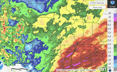
Above is the three day precipitation ending at 11m this morning. Desperately needed rain fell from the Great Plains into the Midwest. Heavy rains, more than six inches in spots, fell from Mississippi into southern Alabama. Unfortunately, a few tornadoes did damage in Louisiana and Mississippi last night and this morning but -- based on the latest reports -- the damage was not major and no fatalities were reported.  The white from Kansas into New Mexico and Colorado are what farmers in social media are calling the "million dollar snow." As much as 15" fell in far western Kansas. Winter wheat is planted in the fall, goes dormant in the winter, then grows rapidly in spring. It is harvested in early summer. This snow gradually melts providing soil moisture and -- when it is extremely cold -- protection from the elements. 

Early Start to California Rainy Season

Image
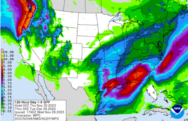
As much as 6 inches of precipitation (rain + the moisture content of snow) is forecast in the Sierra of California) during the next five days.  Given the rain they've already had the past 30 days, it equates to an early start to the California rainy season. 

This Week's Precipitation; Plus Storm Season Advice

Image
A very active week of weather is ahead! The gray square in the middle Mississippi Valley is an area where I believe the amount of precipitation is under-forecasted. This includes the areas from the Kansas Flint Hills to the Great Lakes where no rain is forecast to fall. There may also be snow, in significant mounts, farther south in Iowa and eastern Nebraska.  California, Oregon and Washington will continue to receive significant rain and snow (higher elevations) this week.  Tornado and Severe Thunderstorm Season Preparations   While preliminary, there is a good chance of severe thunderstorms near and east of Interstate 49 (roughly Kansas City to New Orleans) Friday and Saturday. If you have not prepared for tornado season 2025, the next few days will be a good opportunity to do so. What does that mean? Make sure family members know where to shelter in case a tornado warning if you aren't home.  Insure you have at least  two independent ways of receiving warning...

This Week's Precipitation

Image
Quite wet in the East and Northwest with little precipitation elsewhere. 

This Week's Precipitation Amounts

Image
Here is the forecast from now until next Sunday.  Last week's precipitation:

California Precipitation Amounts

Image
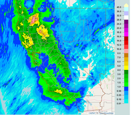
 Up to 3pm PST, here are the precipitation amounts. Below is the latest radar (3:40pm): Rain, with snow in the mountains, continues. The inland atmospheric river extents along and just north of I-15 to Cedar City. 

Seven-Day Precipitation

Image
The switch to the wet pattern on the West Coast is underway. If you note, those are extreme precipitation amounts with as much as ten inches in several locations in California.  The snow will generally be confined to higher elevations because there is little cold air around the United States. 

Precipitation Outlook Next Ten Days

Image
Here are the forecast rainfall amounts for the next five days (Wednesday evening). I have higher than average confidence in the 6-10 precipitation amount forecast.

Heavy Rains in the Northwest and South

Image
While the rains will be heavy in the Northwest with as much as seven inches predicted over the higher elevations, the flood threat will be mitigated by the dry conditions in recent months (see below).   In the South, there are also drought conditions which will mitigate the flood potential. There is a good chance of snow and/or freezing rain in the Midwest. I'll post separately on this threat in the next couple of hours.  Palmer Drought Index as of the 23rd The deeper the reds, the drier. The deeper the blues, the more wetness is being experienced. 

Moisture Amounts for Winter Wheat

Image
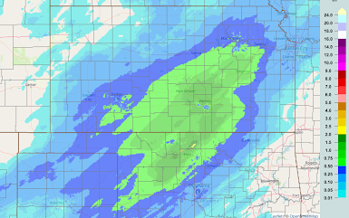
As of 8pm CST, here is the rain gauge + radar estimations of the amount of water contained in the snow. This snow is, by far, the best thing that could happen to the 2024 winter wheat crop.  Snow amount maps, with overlap, are below.

7-Day Precipitation Forecast

Image
Above is the forecast precipitation between now and 7am CDT next Wednesday. Unfortunately, more precipitation -- heavy in the mountains -- is likely in California. At the same time, drought conditions are likely in the heart of the winter wheat belt. 

7-Day California Precipitation and Forecast

Image
These are rainfall amounts to 5am, broken down to into thirds. There is a small 15" area south of Eureka.  There are two 15 inch areas, one in the Sierra and one in the coastal mountains.   Of course, the above are precipitation amounts: rainfall plus the moisture content of snow. As to snow, here is a photo from the mountains. Most ski resorts are closed due to too much snow.  Forecast Precipitation For Seven Days Ending 10a PDT March 18 Heavy rains and mountain snow are forecasted to fall again next week. Here is the 7-day precipitation forecast for California and with an enlargement of central California.  There is a serious risk of more flooding this week. There is also the potential that more highways, including I-80, could be closed. As always, I will keep you updated.  ADDITION: Extreme impacts forecasted through Tuesday.

January Precipitation

Image
Here is the precipitation (rain + moisture content in snow) for the last 30 days.  Below is the departure from normal precipitation in inches.  The departure from normal on the West Coast is interesting. California had flooding rain and snow while Oregon had an extremely dry month.  Below are the forecast precipitation amounts until the morning of February 8.

Precipitation Forecast for the Next Five Days

Image
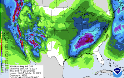
While it is too soon to make a specific forecast as to where and how much snow may fall, there is a good chance of a winter storm in the central Great Plains between Wednesday and the end of the week (there may be two lower pressure systems that affect the region). That's a "heads up" to watch the forecast if you are planning travel or outdoor work.  Below is a forecast of precipitation amounts (rain and water content of snow) from 6pm CST this evening to 6pm Thursday. Note the heaviest rains of the season are forecasted to occur between Los Angeles and San Diego.  Now that the drought has eased (not ended) in California with more rain on the way, by far the worst drought conditions in the nation are in the central Great Plains as indicated by the Palmer Drought Index. Please watch this blog for additional forecasts over the next few days. 

Three-Day California Precipitation to 4pm PST

Image
Desperately needed rain falls in Northern California. Over the next few days, the rain will shift to the south. 

Attention: Returning Holiday Travelers

Image
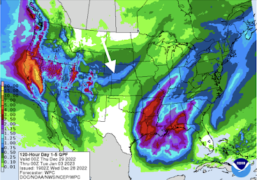
Here is the forecast precipitation between 6pm CST this evening to 6pm CST on Monday, January 2nd.  As you can see, this is forecast to be a very active period. I would expect I-80 to be closed across the Sierra at least once. I also believe the snow band across the Great Plains (arrow) may end up occurring at least a bit father south than indicated.  Given the meltdown at Southwest Airlines , I would be extremely reluctant to fly them during this period with at least two more coast-to-coast storms on tap. I would also be proactive and have "Plan B" reservations in mind in case yours get cancelled (i.e., you'll find airline reps are often happier if you have something in mind rather than asking them to fish the reservation system for you), regardless of airline. While the timing during a holiday travel period is lousy, it is great that this moisture will put a significant dent in the drought in the West.  Also, thunderstorms, some strong, will be numerous in the area outl...

Radar for Meteorology Students

Image
Here's a little tip that can be used when interpreting radar images, especially in winter when stratiform rain and snow have lower cloud tops than in summer.  What does this radar image show? When a radar echo has a circular edge, it is nearly certain the precipitation extends farther in that direction than the radar depicts. Why? The reason is that the radar overshoots the rain or snow.  This illustration is a simplification in that the radar beam curves  at a much lesser rate than the earth's curvature.  The overshooting results in a circular edge to the radar echo. And, when the circular shape is between the radar and the precipitation, it means the precipitation is not reaching the ground. 

Update on Cloud Seeding

Image
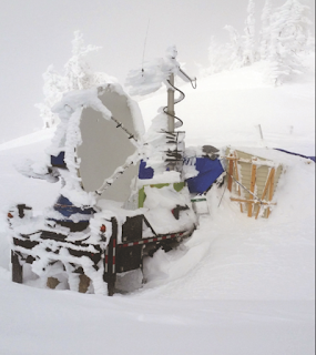
I get asked about cloud seeding all of the time and I haven't had much new to tell people in recent years. So, I'm grateful to the Washington Post  for a really interesting article on the topic. The bottom line is that it is finally proven that cloud seeding works in certain circumstances .  Snowed-over experimental radar equipment NCAR photo There are two big qualifications: It is only proven it works in stratiform-type precipitation in mountain areas. We still don't know for certain whether it works with thunderstorms or in areas outside of mountains.  The increase of 3.3% is over what would have fallen anyway. In other words, if you don't have precipitating clouds, cloud seeding will not help. Still it is a significant scientific advance to know for sure that cloud seeding works in those circumstances. 

March Rainfall in the Winter Wheat Belt

Image
Here is the total rainfall. And, here is the departures from normal rainfall in inches. Moisture is, overall, adequate or more than adequate. In central Kansas, a major wheat producing area, the 60-day rainfall is about normal due to rain and snow earlier in the winter.