
Radar for Meteorology Students
Here's a little tip that can be used when interpreting radar images, especially in winter when stratiform rain and snow have lower cloud tops than in summer.
 When a radar echo has a circular edge, it is nearly certain the precipitation extends farther in that direction than the radar depicts. Why?
The overshooting results in a circular edge to the radar echo.
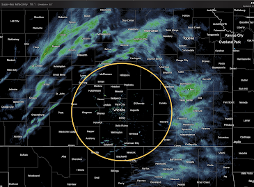
What does this radar image show?
The reason is that the radar overshoots the rain or snow.
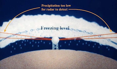 |
| This illustration is a simplification in that the radar beam curves at a much lesser rate than the earth's curvature. |
And, when the circular shape is between the radar and the precipitation, it means the precipitation is not reaching the ground.


Comments
Post a Comment