
Winter Storm Forecast Update
If you live in eastern Kansas or adjacent areas, I have a winter weather update for you. Please make sure your friends and family are aware of this change in the forecast.
Above is the amount of snow I predict to fall but not all of it will accumulate because of the very warm ground. However, wind gusts will be to 35-40 mph which means there will be drifting and blowing snow -- making driving very hazardous during daylight hours Saturday, especially between sunrise and noon..
The low pressure system is tracking farther west than originally forecasted and there will be a slight amount of instability. The result is that there will be a band of heavy falling snow farther west -- between the Missouri border and the Flint Hills -- than initially expected. It is even possible that an isolated "snow thunderstorm" could occur.
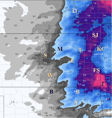 |
| Please note: the band of heavy snowfall could shift ±25 mi east or west. |
The snow will reach the Kansas-Nebraska/Missouri-Iowa border areas by around 8pm this evening and will drop south from there. Snow should end in Kansas by sunset Saturday.


Comments
Post a Comment