
Precipitation Forecast for the Next Five Days
While it is too soon to make a specific forecast as to where and how much snow may fall, there is a good chance of a winter storm in the central Great Plains between Wednesday and the end of the week (there may be two lower pressure systems that affect the region). That's a "heads up" to watch the forecast if you are planning travel or outdoor work.
 Please watch this blog for additional forecasts over the next few days.
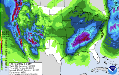
Below is a forecast of precipitation amounts (rain and water content of snow) from 6pm CST this evening to 6pm Thursday. Note the heaviest rains of the season are forecasted to occur between Los Angeles and San Diego.

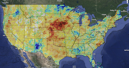
Now that the drought has eased (not ended) in California with more rain on the way, by far the worst drought conditions in the nation are in the central Great Plains as indicated by the Palmer Drought Index.


Comments
Post a Comment