5:15pm Update: Winter Storm and Major Tornado Risk Forecasts
National Weather Service Warnings and Advisories
- Pink = winter storm warning.
- Turquoise = winter storm watch
- Purple = winter weather advisory (lesser condition)
- Amber = high wind watch
- Light brown = high wind advisory
The forecasts below still look good. Please keep in mind that Arkansas and, especially, Oklahoma do a very poor job with winter storms. I urge you to leave early and avoid the storm if at all possible.
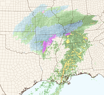
Forecast Radar: 9am Tuesday
Forecast Radar: 5pm Tuesday
Forecast Radar: 11:59pm Tuesday
Forecast Radar: 9am CST Wednesday
Updated Snow Amount Forecasts
From now until 6am this Tuesday
6am Tuesday to 6am Wednesday
6am Tuesday to 6am Wednesday Zoom
Zoomed forecast for 6pm Monday to 6pm Tuesday. Winds will be moderate with this storm, so there will be a little drifting but nothing major. Note: there is a chance of a snow thunderstorm south of I-40. When once occurs, a quick additional inch or two is possible. Tornado Risk
Unfortunately, for the fourth time in 2023, we have another major tornado risk in Texas and in the South. The forecast below is valid from 9am Tuesday to 6am Wednesday. From Louisiana, east, there is only a very small risk of tornadoes in the morning, the odds will increase in the afternoon.
Color codes:
- Hatching = strong tornadoes possible.
- Yellow = enhanced risk of tornadoes.
- Brown = significant risk of tornadoes.
If you live in these areas please monitor the weather throughout the day.


Comments
Post a Comment