
Updated Winter Storm and Severe Thunderstorm Forecast
Here is the latest forecast snowfall values for the upcoming winter storm.
 Color codes:
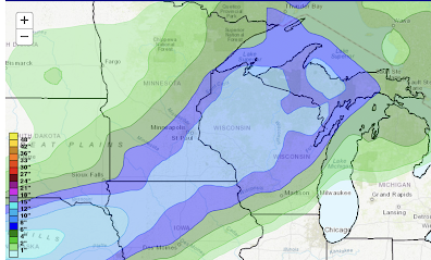
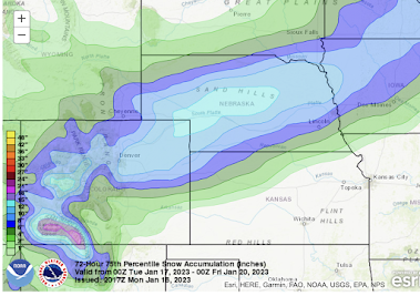
 The snow amount forecast is valid from this evening until 6pm Thursday. I don't think the wind will be a major factor, so I am not expecting significant drifting of the snow. However, it will cause major travel difficulties. If you are traveling through the airports at Denver, Omaha and, to a lesser extent Minneapolis, please consider modifying your plans to avoid the storm. For example, the snow will begin after:

 Color codes:
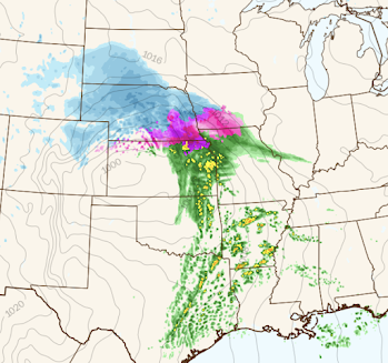
First, the forecast radar. It is valid at 10am Wednesday.
Forecast Radar 10am Wednesday

- Blue = snow. Darker blues are heavier rates of falling snow.
- Pink and purple = Sleet, freezing rain and mixed rain/snow.
- Green = rain.
- Yellow and red = thunderstorms. There is a risk of tornadoes and severe thunderstorms in the south. See below.
Snow Amounts


DEN: 4-8" Snow starts after 7pm MST Tuesday
OMA: Ice and 3-6" Ice or snow starts after sunrise Wednesday
MSPs: 4-8" Snow starts Wednesday evening
Believe me, you'll be happy to miss the airline mess that is likely to occur with the winter storm.
There is also the possibility of tornadoes and severe thunderstorms Wednesday and Wednesday night, especially in the yellow area.

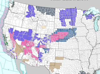
Finally, here is the NWS's watches/warnings, etc., as of 4pm.

- Green = flood warnings (California)
- Pinks = winter storm warning
- Dark green = winter storm watch
- Purple = winter weather advisory (lesser condition)
- Gray = dense fog advisory
I will update on the winter storm tomorrow morning.


Comments
Post a Comment