
Another Blast of Cold Air Moving In!
As this is being written, another blast of Arctic air is moving south.
By Tuesday morning, the coldest of the air will bring below zero temperatures to much of the nation. Single digits will extend from Ohio to Texas. 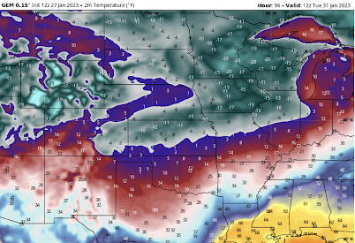 Please prepare accordingly, including caring for your pets.
 The wind forecast is below with Lincoln and Omaha circled. Their forecast wind speed? Just 3 mph!
Since wind turbines do not turn with wind speeds of less than 6 mph, virtually the entire area of below zero temperatures will have winds too light to generate electricity from wind.
 More on the snow, here.
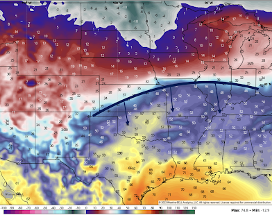
Below is the temperature forecast and the location of the cold front at noon tomorrow (Saturday) from the Canadian Global model.


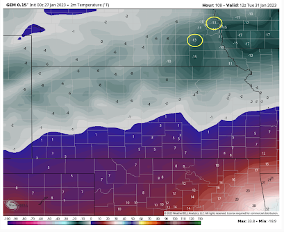
While on the subject of extreme temperatures, I often talk about how wind energy fails when needed the most. Below is a closeup of forecast temperatures Tuesday morning for Kansas and southern Nebraska. Note Lincoln and Omaha forecast to be -13°F (circled).

 |
| Numerals are wind speed. Arrows are wind direction. |
What makes this especially significant is that Kansas is the #2 state for wind energy. Northwest of U.S. 56 the wind will be too light to produce any appreciable amount of electricity during a period when demand for electric heat will be extremely high.
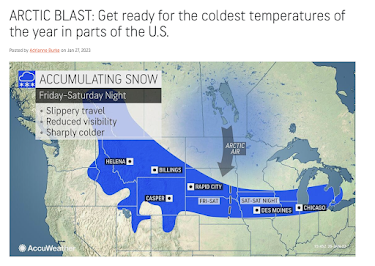
Addition: AccuWeather has a nice graphic of the forecast snow in the northern Great Plains.

Note: Lots of blogs are talking about an ice and snow storm next week somewhere in the southern half of the Great Plains. That is still quite speculative at this point. Hopefully, the situation will clarify tomorrow as to whether an ice storm will occur and, if so, where. Check back, please.


Comments
Post a Comment