Posts

Showing posts with the label Great Plains

Great Plains and Midwest Flood Threat

Image
Looks like next week features a major flooding risk across the central Great Plains and western Midwest.  Here is a forecast of rainfall for the next 12-days. The remains of Hurricane Polo will cause as much as eight inches of rain over this time period. The band of heaviest forecast rain may have to be widened a bit to the south.  Three to 5" inches of rain was widespread over the southeast half of New Mexico this past week causing serious flooding in a number of areas. Additional heavy rain, on top of saturated grounds, could cause major to record flooding.  As much as 4" occurred last week in north central Kansas where an additional 5" of rain is forecast. Again, major flooding is possible.  I urge you to keep on the weather this week if you live in the affected areas. 

Tornado Risk Today- Updated 2:15pm; 4th Tornado Watch

Image
-- original forecast, still valid -- Yesterday saw many tornadoes in the central Plains, several of which were strong. I believe we are in for another day of severe weather only this time a bit farther east.  Here is the color code for this forecast based on my 4-point scale. Note: the highest on my scale is an extreme risk which is  not  being forecast today.  Red, hatched =  high  risk of strong tornadoes.  Yellow, hatched =  enhanced  risk of strong tornadoes.. Brown = a significant risk of tornadoes.  Large or very large hail is likely over this same region. Damaging Winds The purple hatched area has a high  risk of wind gusts of 75 mph or stronger. The red area has an enhanced risk of wind gusts of 60 mph. The yellow area has a significant risk of gusts of 60 mph or stronger.  Safety Recommendations If you live in a mobile home or need a public shelter, you will find lists and maps  here . Please check it now, before ...

Central and Southern Great Plains: Heads Up

Image
This long range forecast of the potential for severe thunderstorms and tornadoes is generated by Dr. Victor Genesini and has generally proven -- when it is at an exceptionally high level as shown above -- to be of high quality. The forecast begins April 24.  This would be a good time to consider installing any storm mitigation devices (generators, etc.) you might be considering or clearing out your storm shelter 

Weekend Tornado and Severe Thunderstorm Forecasts

Image
Saturday's forecast has been updated . Sunday's is still valid.  Sunday may be an active day for tornadoes, damaging thunderstorm winds, and large hail.  Here are the forecasts: Saturday This is the hail forecast (the likelihood of tornadoes, while not zero, is low). There is a significant risk of hail 1" or larger in the yellow area. In the hatched area, the hail may be larger than 2". The latter area includes Wichita, Tulsa, Oklahoma City, Norman, Enid and Arkansas City.  Sunday The hatched yellow area has an enhanced risk of strong tornadoes throughout. I would especially be concerned about the area from Jonesboro to Cape Girardeau, Paducah, Carbondale and Evansville based on recent data.  The brown area has a significant risk of tornadoes. Now is the time to make sure your tornado safety area is ready to go. If you reside in the manufactured or mobile home, and your area does not have a shelter, there is a map/list of community shelters here . 

Extreme Wildfire Risk Friday! -- Updated 3:30pm

Image
The wildfire risk Friday -- especially in the afternoon -- is high in the entire shaded area. But it is extraordinary high in the purple area.  It is absolutely essential that wildfires be prevented from starting. Recommendations: Don't drag chains.  Don't throw out cigarette butts.  Avoid operating equipment that can spread sparks.  No campfires! Keep vehicles off dry grass. Stay on the road.  Please take this threat seriously. 

Forecasts for Two Winter Storms

Image
Note to readers at 11:45pm Wednesday, January 1: after a quick look at this evening's data and models, the forecast below still looks good.   This is important information for anyone traveling the next few days. Please factor it into your plans.  Winter Storm #1 Above is a close-up of snowfall amounts in the Midwest. East of the Rockies, the snow will begin over Nebraska tonight.  The snow will spread east into Iowa tomorrow (Thursday) morning and then farther east. Heavier amounts are likely over the Appalachians.  Weekend  Storm #2, Major Storm Forecast Above is the snapshot forecast weather map for 6am Sunday. A strong low pressure center is forecast to be over southeast Kansas with severe thunderstorms possible during the day over the south central U.S. as well as freezing rain and sleet in the purple area and heavy snow in the dark blue area. The models are showing wind gusts of 30mph or even stronger in the icing area of central and northeast Kansas which ...

Severe Thunderstorm and Heavy Rain Threats Next Week

Image
Central United States There will be scattered areas of flooding in the outlined area from Sunday through Tuesday.  Forecast rainfall to Wednesday night: There is also a risk of tornadoes and damaging winds Sunday-Monday Night in the area outlined below.  Geographically, this is likely an overforecast. However, in this rapidly developing situation I want to make sure people are aware of the threat.  Northwest Late in Week While lighter rains will occur Sunday through Wednesday, torrential rains -- with amounts of more than ten inches over the higher elevations -- flood is likely by next weekend. 

[Updated] Thursday and Friday Tornado and Severe Thunderstorm Risk

Image
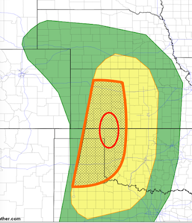
Thursday and Thursday Night Forecast The yellow area has a significant risk of tornadoes and severe thunderstorms (large hail and damaging thunderstorm-generated winds). The orange, hatched area is where there is an enhanced risk  giant hail and tornadoes are more likely. The red oval is where I believe there is a higher risk of tornadoes, especially Thursday evening.  Update:  The NWS has updated their forecast for Thursday and it is below.  Their red area is very similar to my orange area. However, they pull their higher risk area to include Hutchinson and Pratt and it is close to Wichita. Where you see red + hatching in their forecast there is an enhanced risk of strong tornadoes and  hail 2-3" in diameter. Elsewhere, where you see the hatching, there is a risk of tornadoes but the primary risk is hail ≥ 2 inches.  With the potential for strong tornadoes, it is important to monitor the weather Thursday (and Friday, see below). Of course, I will...

Winter Wheat Weather Outlook

Image
Finally , the NWS has recovered the past two weeks' rainfall amounts and they are depicted for the winter wheat belt below. This rain will be, in part, provided by severe thunderstorms with the potential for tornadoes. Please scroll down. The dry weather from central Kansas to northeast New Mexico, along with adjacent areas, has caused some deterioration of the crop, especially in southwest Kansas.  Here is the National Weather Service (NWS) forecast rainfall amounts for the next seven days.  Please note the area where 5" is forecast in central Missouri. As this area has been fairly dry, I don't think there is much chance of major flooding. However, the area of 4" rains in eastern Oklahoma into the Arkansas Ozarks has received above average rainfall, so people in flood-prone areas should keep an eye on the weather starting Thursday night.  The rain will be a huge boost to the wheat crop but, unfortunately, it does not include much rain for the area of the High Plains ...

Tornado Forecasts for the Plains Today and South on Monday - Post Updated at 3:05pm

Image
New watch until 3am. A tornado or two; large hail and damaging winds. Includes DFW Metroplex.  A couple of tornadoes are possible along with hail up to 2" and wind gusts to 70 mph are likely in this area until 9pm.  Later Today and Tonight The above map, in brown, shows where there is a significant risk of tornadoes after 3pm today and into this evening. The tornado warning risk should end by around 9pm.  However,  there is a slight chance that a line of thunderstorms may form south of I-40 in Oklahoma and far north Texas after around 11pm. If that occurs, large hail and damaging winds are possible. This is a forecast map of where hail 1" in diameter or larger is forecast to fall. The yellow has a significant risk and the red has an enhanced  risk of large hail. Monday and Monday Night As above, the brown area has a significant risk of tornadoes. The yellow, hatched area has an enhanced risk  of  strong tornadoes. It will be very important to monitor t...

Major Storm to Affect West Coast Then Central U.S.

Image
There are two storms (#1 and 2) near the coast that will move inland bringing rain -- snow in the higher elevations -- to the West.  Storm #2 is racing east and will help trigger severe thunderstorms with a risk of tornadoes late Tuesday . Storm #1 is causing rain in Southern California today that will continue into tonight.  Storm #3 looks like a monster with extreme mountain snow and, in places, flooding rains in the West. Severe thunderstorms are possible in the Great Plains. Blizzard possible in the Rockies and/or northern Plains.  Here are details. These are the precipitation maps from 4pm this evening to 10pm Sunday.  Warnings are already going out about 6 to 9 FEET of snow in the Sierra Friday and Saturday. It is too soon to get specific as to where the severe thunderstorm, and possibly tornado, threat may develop. I will cover that beginning about Thursday. I'll start covering the blizzard threat on Wednesday. 

Tornado, Hail, and Wildfire Forecast for Tuesday [Updated, 4:45pm]

Image
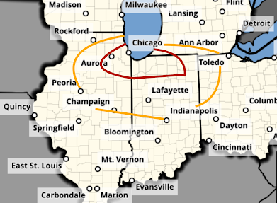
There is a significant risk of tornadoes tomorrow in the Midwest after about 4pm. The first of the severe thunderstorms will probably develop over Illinois. The area in orange has a significant risk of a tornado. The area in red, which includes Chicago, has an enhanced risk.  There is also a risk of giant hail -- two inches or larger -- in the hatched area. In the remainder of the yellow area, there is a significant risk of 1" or larger hail. There is also a critical wildfire risk of wildfires in the red area over the southern High Plains.  Of course, I will update on these risks tomorrow. 

Important Snow Information; Including Near Blizzard Conditions in the Northeast

Image
Color Code: Pink = winter storm warning Purple = winter weather advisory, a lesser condition  Green = river flood info Northeast Color code: Dark blue = winter storm watch Pale green = coastal flood watch This is a preliminary forecast of snow amounts. They may need to be adjusted a bit and  the snow band may need to be adjusted north-south a bit. Regardless, this will be a major winter storm  because The numbers are peak  wind gusts during this storm. Many areas will have gusts of 40 mph or stronger which means drifting snow and major travel issues. 

Two Areas of Winter Weather! [Updated 7:25pm CST]

Image
Two major areas of winter weather. Please review the forecasts below and check back from time to time as I will be updating all weekend.  Let's Begin with the Northeast.  Dark blue is a winter storm watch. Pale green is a coastal flood watch and the bright green is a river flood warning. Update: high winds now appear to be possible with this storm.  Preliminary snowfalls. The snow should begin Monday night.  Great Plains Pink is a winter storm warning  and blue is a winter weather advisory (lesser condition). Greens are river flood warnings.  Forecast snowfall from now until 8am Monday. I still believe a few of the areas shown are an over-forecast (too much snow) but there is a possibility of snow thunderstorms which have been known to dump great amounts very quickly.  Forecast radar for 9am Sunday.  Forecast radar for 11pm Sunday (after the Super Bowl parties).