
Posts

Showing posts with the label barometer

Global Warming Silly, Err, Baseball Season
Image
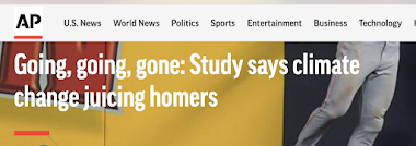
This Seth Borenstein Associated Press story that contends global warming causes more home runs is just silly. As I've written many times, Big Climate is getting desperate because their 35 years of "the sky is falling" isn't getting the traction, nor the changes in government, they want.  The Washington Post  has also run a story of its own.  Their stories are based on an even sillier paper published in the Bulletin of the American Meteorological Society  yesterday. The paper evidently lacks figures that are referred to in the text, so its reasoning is hard to follow. It contains a number items that cast doubt on the its own findings. For example, Firstly, we estimate models with and without air density as a separate term (Table S5), which shows that when both temperature and air density are included, only air density has a statistically significant effect. While there is no "Table S5" that I can find, doesn't the fact that temperature does not have a ...
Amazing Satellite Animation of the Volcanic Pressure Wave

Image
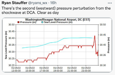
Saturday, we walked about the barometric pressure wave from the Tonga volcano explosion as it moved across the United States. For example, the red line (below) shows the very rapid fluctuation in barometric pressure at Washington, DC.  The Pacific GOES-17 weather satellite's sensors (not of the type you see in television weathercasts) was used to created an animation of the wave as emanated from the eruption. A screen capture is below. The animation is here . Just amazing. Thanks to William Barlow for the animation. 

My Barometer Continues to Show Falling Pressure

Image
At 2:20pm CDT... My personal barometer is falling past 29.10" but I doubt it will go much lower. You can see it has fallen more than 1" in less than 24 hours. Below is a great example that helps illustrates the correlation between low barometric pressures and wind. Via Twitter, here is a photo at the same time of a barograph in Jackson, Tenn. (N of Memphis). The difference in pressure (the "pressure gradient") is huge. Wind flows from high pressure to low pressure in the same way as water (water and air are both fluids) flows from the top of a mountain to the bottom. The wind accelerates when there is a large pressure gradient. Below, from 2:10pm, is a graphic of the wind spiraling into the center of the low from all sides. The center of low pressure has moved into west central Kansas between Syracuse and Garden City based on readings from the Kansas Mesonet .

Barometer Dropping Like a Rock

Image
Here is the barometer reading at my home at 11:40am CDT. It will likely drop below 29" which is a rare value (scroll down to compare to yesterday evening). The State of Colorado set a record low reading this morning -- dating back to the 1880's.

Pressures Are Falling Rapidly

Image
When I was nine years-old, my Grandmother gave me this barometer which has been keeping accurate pressure readings since. I set the tracking needle at 11:50pm yesterday when the pressure was 30.16 inches. As of 6:15pm, the pressure had dropped to 29.78 inches. It will fall rapidly the next 15-20 hours. I'll try to get a photo when it is near the lowest pressure. There is a good chance the minimum pressure will drop below 29" which it has done only a few times in my life.

RECORD STORM FOR ROCKIES AND GREAT PLAINS WEDNESDAY

Image
Update: 12:04pm CDT Tuesday:  The blizzard warning (orange) has again been expanded. It is extremely likely the following cross-country interstate highways will be closed due to blizzard conditions Wednesday/Wednesday Night: I-70, west of Denver to western Kansas. I-80, eastern Wyoming to western Nebraska I-76, Colorado and Nebraska (nearly entire route) I-25, Colorado and southeast Wyoming I-40, Texas and eastern New Mexico may be closed because of wind (only) I-27, Texas (wind only) Rest of information below is unchanged. If you will be in or over (yes, the cautions include flying) the region, heads up!! Make sure your friends or family in the area are aware as this storm was not publicized until yesterday afternoon. Please do not let your family to travel into areas outlined below. This storm is so strong meteorologists forecast all-time state minimum barometric pressure records to be set in both Colorado and Kansas tomorrow. It is the strongest storm of it...

What is the Device Behind Alan Harper's Head?

Image
In tonight's Two and a Half Men,  I spotted a familiar device behind Alan Harper's head: A barograph. It is a pen device attached to an aneroid barometer that creates a tracing of the barometric pressure. The paper chart is typically changed once a week. Here are the essential parts: click to enlarge Bet you didn't know you could learn about weather instruments from watching network TV? Until tonight, neither did I. This model barograph was sold by Taylor Instruments when I was a kid. You can see a closeup photo here .