Posts

Showing posts with the label Topeka

Today's Tornado Risk

Image
In addition to an elevated risk of flash flooding , the brown area has a significant risk  of tornadoes late this afternoon and into tonight. Please monitor the weather in this area!

Flash Flood Danger Tonight

Image
The red area has a 40 to 65% chance of flash flooding tonight.  If you have errands to run, I recommend doing them sooner rather than later (time 3:15pm) as thunderstorms are starting to develop in northeast Kansas. Please keep up on the weather if you live in the red-tined area.  Remember: the leading cause of casualties in flash floods is people trying to cross flooded areas by foot or by car.  The yellow stripe has a 15-30% chance of flash flooding.  The atmosphere is filled with moisture and a weak low pressure area aloft over western Kansas is slowly drifting east which should be the trigger from the storm. More than 5" of rain is being forecast over eastern Kansas. 

6:15pm -- Damaging Wind Risk Downgraded

While there will be scattered thunderstorms with 60 -65 mph winds into Sunday evening, the higher risk of stronger winds in eastern Kansas is no longer forecast. 

6 pm - Current Tornado Forecasts

Image
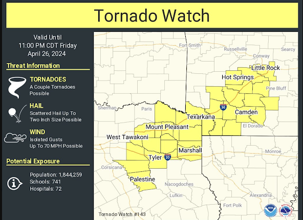
Tornado Watch until 11pm. Tornado Watch until 9pm. This watch has been cancelled for Kansas.    Tornado Watch until 9pm.   More tornado watches are below, please scroll down.  Tornado Watch until 7pm. Updated Forecast  The yellow, hatched area has an enhanced risk of tornadoes. The brown area has a significant risk. Kansas City has been removed from the enhanced risk of tornadoes but remains in the significant risk.  Below are close-ups of the tornado risk areas. Please keep up on the weather in these areas, especially if you live in the hatched area. You can follow my real-time updates on Twitter @usweatherexpert.  You may wish to recommend this blog and my Twitter handle to friends and relatives in the affected areas.  If you, for example, live in the mobile home and need a community shelter, a list and map is here .  I am going to make a separate posting for tomorrow's tornado forecast. It should be up early this afternoon. 

Update on Tornado and Giant Hail Threat; Updated 6:50pm

Image
Thunderstorms are developing in Kansas from the Flint Hills west to I-135. They are currently moving NNE but will turn more to the northeast over time. The yellow polygon is a severe thunderstorm warning as of 6:48pm. These storms may produce giant hail and/or tornado(s).  This will be the last blog update. Additional updates will be on Twitter @usweatherexpert.  Tornado Watch Until 1am Tornado, tennis ball-sized hail and gusts to 70 mph are possible in the yellow area, including Kansas City, Topeka, St Joseph, and Sedalia. First eastern Kansas storm of the evening is about 25 mi. SSW of Manhattan and will move NE.  For updates, please follow me on Twitter @usweatherexpert.  Severe Thunderstorm Watch Hail to 2", wind gusts to 65 mph, and -- perhaps -- a tornado is possible in the yellow counties of Kansas and Nebraska.  Mississippi Valley Threat In addition: Here is a severe thunderstorm watch with "a couple of tornadoes possible" that includes the St. Louis Bi-...

Kansas Is Such a Great State

Image
Wall Street Journal story from yesterday has a great story pertaining to Topekans inviting immigrants to their city. They are teaching the children English in the schools and training their new residents for jobs which are in demand.  Wichita did something similar for the "boat people" fleeing Indochina in the 1970's.  Kansans are welcoming, friendly people. It is such a great state! [If you lick on the READ MORE link, it will take you to a second line, red, that will allow you to read the WSJ story.]

Chance of Tornadoes in the Central Great Plains Saturday

Image
I'm posting this preliminary forecast since this is the highest chance of tornadoes in parts of this area in two years. I'm concerned that some may be out of the habit of getting their shelter area in shape, et cetera. The hatched yellow area is where strong thunderstorms could occur if the "cap" (a layer of warm air about 6,000' above the ground) should not be as strong as currently forecast. So, if you live in Wichita, Topeka or other parts of the yellow areas northwest (left) of the red line, I recommend: Check your shelter area, make sure it has a couple of bottles of water and a flashlight.  Always wear shoes into your shelter area. Put fresh batteries into your weather radio. If you haven't already, activate WEA alerts on your smart phone (under "notifications"). That's it. Then, start monitoring the weather after about 2pm Saturday.  Of course, I will update the forecast between now and then.