Posts

Showing posts with the label Doppler radar

The Attempt to Mislead Regarding Layoffs at NOAA

Image
Updated 11am Monday: -- original posting -- You may have awakened to this 'news' at the Drudge Report this morning.  Drudge links to the Irish Times ,  an Ireland-based newspaper that detests President Trump. Their headline is below. I believe the  preliminary  death toll is now up to 36 --mostly from the tornadoes.  The Irish Times, and others, are -- intentionally or not -- confusing layoffs at the National Weather Service (NWS) with the parent agency the National Oceanic and Atmospheric Administration (NOAA). The former is a lean agency that issues the tornado, blizzard and dust storm warnings that were needed the past few days and the latter has traditionally had lots of fat that has been or could be cut.  For example, NOAA's cartoonist(s) has been laid off.  I can assure you the layoffs of the NOAA cartoonist(s) and in-house video staff have nothing whatsoever to do with the quality of the storm warnings mentioned above! The newspaper focused on ...

The First Tornado Detection By a Doppler Radar

On a discussion group this week, there has been discussion about the early days of Doppler radar. That was a topic we covered a while back. Here is a piece about the first time a Doppler detected a tornado (the F-4 El Dorado, KS Tornado) with a link to KAKE-TV's outstanding documentary on the topic. 

Pre-"Twisters:" The Origin of Storm Chasing

Image
How did our modern tornado warning program begin? It started in Oklahoma in 1972 with plucky meteorology students and experimental radars. With the huge success of Twisters  this summer and 1996's  Twister before it, it is likely most assume storm chasing has been around forever. Not true! Storm chasing began in 1972 in a classroom of stinky Felger Hall at the University of Oklahoma. Dr. Joe Golden, a scientist with the National Severe Storms Laboratory addressed a meeting of the OU student chapter of the American Meteorological Society.  Joe asked us to chase tornadoes so the efficacy of two experimental Doppler radars could be tested. I was going through some files in my office last week and found the original plans of the storm chase program.  This was well before the era of cell phones. That first season, we spent a lot of time running around Oklahoma under blue skies or cumulus-filled skies -- with few intercepted thunderstorms, let alone tornadoes. But, we lear...

Joplin Tornado Warning Redux

Image
A tornado occurred in the Joplin area early yesterday afternoon and, unfortunately, there were issues with the National Weather Service's warning just as there were on that terrible day in May, 2011, when 161 people lost their lives in that horribly warned tornado .  According to KSNF-TV , which could view the tornado from its cloud camera (just as it did with the May 22, 2011, tornado ), the tornado touched down at 1:35pm. Unfortunately, the tornado warning wasn't issued until 1:42pm, which made for a "lead-time" of an awful -7 minutes.  Below is a screen capture of a video of the tornado (the video is at the red link, above). There's a tornado siren in the video and it is not  rotating -- meaning it is not sounding! Even worse, per a meteorologist in the region, when the tornado was first reported, the NWS called it -- you guessed it! -- a "landspout." Increasingly, I must ask: what training are NWS meteorologists receiving? While warning of this torna...

To Meteorologists: Regarding "Landspouts" - [11:15am Friday, Addition]

Image
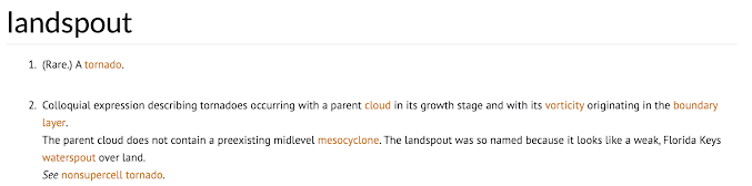
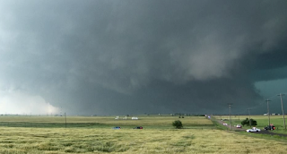
Dear Colleagues, I don't know what prompted the fad of calling tornadoes "landspouts" but, in my opinion, it should stop. Here is the definition of a landspout per the Glossary of Meteorology: Note that it states: The parent cloud does not contain a preexisting midlevel mesocyclone... See non-supercell tornado . [emphasis mine] There were at least three tornadoes called "landspouts" yesterday. This was from Kansas. The tornado shown above came from the mesocyclone associated with the tornado warning at lower left. There was a large tornado a few minutes later. I don't know whether the pictured tornado grew or whether it was what is correctly called a "satellite tornado." Same thing in Texas. At right, the mesocyclone at the time of the "landspout" report is clearly visible.  I've had members of the public ask me, "what is a landspout?" All we are doing with all of these (incorrect) landspout reports is confusing people! Land...

Tornado in the Little Rock Area Friday Evening

Image
From the National Weather Service in Little Rock Saturday morning: You'll find a map and other info at the bottom of this post. --- original posting --- Absolutely classic "hook echo" signature of a developing tornado. A small tornado caused damage southwest of Little Rock earlier this evening. A photo of the tornado is here .  I became concerned about the storm shortly after 6:30. As there was no tornado warning, I let my Twitter followers know that, while the chances were still low, there was possibly of a tornado. There was no tornado watch, severe thunderstorm watch or tornado warning at that point.  At this point, there was rotation aloft (the dashed circle) but none in the lower part of the storm. The "significant tornado parameter" was just barely high enough to indicate the potential for a tornado. I wanted my readers to know about the threat.  By 6:38, seven minutes after the image directly above, we had a hook echo. But, no tornado warning. 6:45pm, the...

Radar Gaps and Tornadoes: Worse in Winter

Image
The point of this article: in winter, it is more important than ever to have your tornado sheltering area ready to go and to move quickly to shelter when a tornado warning is issued.  Posted by Bill Murray Several meteorologists and others have recently posted newspaper images of stories pertaining to tornadoes that have occurred in early winter. The Vicksburg tornado occurred December 6, 1953. There was no warning. The tornado killed 38 and injured more than 250.  A warning might not be optimal if a similar winter tornado occurred in that region today because the area west of Vicksburg (not Vicksburg itself) is in a National Weather Service radar gap (see map below). A number of times over the past year we've discussed issues with storm warnings, which include gaps in radar coverage (example, here ) where proper tornado monitoring cannot occur. With the potential for tornadoes as we get into the weekend, I want to discuss how the gap issue worsens during the winter.  Whi...

The First Tornado Detection By Doppler Radar

Image
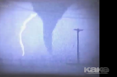
Actual Image of El Dorado Tornado KAKE-TV in Wichita has produced an outstanding  documentary on the first-ever use of Doppler radar to detect a tornado, which was in Wichita in 1958. That tornado struck the City of El Dorado, Kansas. It was an F-4 intensity tornado (would be rated EF-5 today) that killed 13.   After World War II, Wichita received the first-ever weather radar from the Weather Bureau. Then, in 1958 and '59, we and Wichita Falls, Texas, had experimental Dopplers (image below).  The radar in Wichita measured a wind of 206 mph in the El Dorado Tornado. Unfortunately, it would be 34 years before the first operational Doppler radar would be deployed for the detection of tornadoes and other storms.  While I had no involvement in the production of KAKE's excellent documentary, there are some personal notes I would like to add. First, the people of El Dorado have, over the years, been extremely kind to me. I was so honored to speak at the dedication of the t...

2013 Tornado Anniversary Dates

Image
There were two important tornadoes for which today is the tenth anniversary.  El Reno, Oklahoma National Weather Service, Joseph Brennan The National Weather Service in Norman has a comprehensive write-up here . This was the largest tornado in recorded history and, per Doppler radar wind measurements, one of the strongest. Between the tornado and flooding, 21 people died.  St. Louis Area YouTube This storm was very tricky for warning purposes but the NWS and local broadcast media did a great job. No one died in spite of extensive damage -- more damage than occurred in Oklahoma -- as the storm was a long-track F-3 tornado as it went across the densely populated North County area. In addition to it being a more difficult than average tornado warning situation meteorologically, the Weather Channel and others were ignoring the St. Louis threat in favor of the Oklahoma City area where they had a "Tornado Tour 2013" crew. They were rolled by the tornado .   If you wish to read ...