
To Meteorologists: Regarding "Landspouts" - [11:15am Friday, Addition]
Dear Colleagues,
 The tornado shown above came from the mesocyclone associated with the tornado warning at lower left. There was a large tornado a few minutes later. I don't know whether the pictured tornado grew or whether it was what is correctly called a "satellite tornado."

 unquestionably, we should issue them for tornadoes.
 The above is the Doppler wind data at the time of the tornado. The red and green represent a mesocyclone -- which, by definition, disqualifies it from being a landspout.


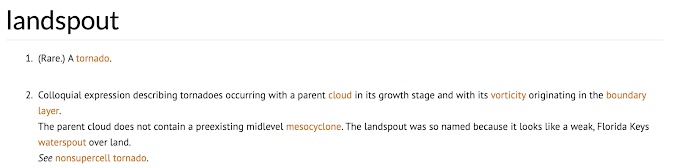
I don't know what prompted the fad of calling tornadoes "landspouts" but, in my opinion, it should stop. Here is the definition of a landspout per the Glossary of Meteorology:

Note that it states: The parent cloud does not contain a preexisting midlevel mesocyclone...See non-supercell tornado. [emphasis mine]
There were at least three tornadoes called "landspouts" yesterday. This was from Kansas.

Same thing in Texas.

At right, the mesocyclone at the time of the "landspout" report is clearly visible.
I've had members of the public ask me, "what is a landspout?"
All we are doing with all of these (incorrect) landspout reports is confusing people! Landspouts are dangerous tornadoes (not to be confused with "cold air funnels"), so we want people to take exactly the same safety measures as with a "tornado." What's the point?
While I don't believe we should issue tornado warnings for gustnadoes,

I don't know whether to call it a "fad" or whatever, but calling genuine tornadoes "landspouts" should stop immediately.
With very best wishes,
Mike
P.S., so I am in another city at the moment and I wanted to hear what happened with regard to the tornado I had heard about near Joplin. Turns out, it was just north of the city in their suburbs. When I turned on the television, they were in the process of going to their meteorologist for an explanation and -- you guessed it -- he said, "It was a landspout-type of tornado." No, it wasn't. [More below.]

This tornado didn't even look like a landspout. The wide "wall cloud" above the tornado was the mesocyclone.

[Addition, Friday morning 11:15am]
And, here is where the "landspout" reference originated.

Below is a photo of two landspouts (look closely at right). Of course, as explained above, it isn't the appearance that makes it a landspout or not. It is whether there is a mesocyclone.

I don't know how this landspout fad began but it needs to stop. It is doing nothing but confusing people.


Comments
Post a Comment