The Extreme Tornado Risk Forecast: The Day After
Today is the day after one of the most urgent tornado forecasts in years.
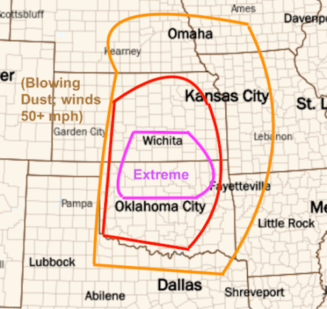
I validate my forecasts rather than the NWS's. If you scroll down, you'll see the forecast I made Sunday afternoon and the tornadoes reported, so far. I predict that in three days -- after the NWS's field surveys-- the number of red dots will double. Three of the existing red dots are of the violent, fatal tornado that destroyed much of Barnsdall, OK and did significant damage in Bartlesville. The Oklahoma side of the forecast was pretty good. I suspect the enhanced area (red) and significant (orange) will work out when all of the reports are in.
The one area that didn't work out? The Kansas side of the extreme risk, including my home of Wichita.
When it comes to weather forecasting, people's emotions often invert. The late meteorologist Allen Pearson used to tell a joke about a "little old lady" who mistook tornado watches for warnings.
- Lady calling on phone, "You kept me in my basement for hours and nothing happened!"
- Pearson: But, it was a watch and you weren't supposed to go to the basement.
- Three days later, another tornado watch. Nothing happens.
- Lady, "You kept me in the basement again for no reason!"
- Two days later, a tornado warning and she goes to the basement. Her home is destroyed.
- Lady, after struggling to get to a neighbor's phone (hers was destroyed), calls Pearson:
- Lady: That's more like it!!
I suspect that people on the Kansas side of my "extreme risk" area are feeling a bit like the old lady today. Because I so rarely (only the second time) forecast "extreme" tornado risk, I spent three hours on that forecast to make sure it was of high quality. To be honest, I don't know why it busted in Kansas, especially when, as late as 1pm yesterday, one of the highest resolution models showed a tornado striking the west and north parts of our city!
Above is the forecast, below is the reality (map of actual tornadoes updated 5-14-24):
Tornadoes May 6 to 7am May 7, 2024
The forecast worked out well everywhere but south central Kansas
So, southern Kansans get the, "I'd love to get paid (even though I do it for free) for being wrong half the time" out of your systems today. You are entitled. But, please send some money to the Salvation Army's Disaster Relief fund to help your fellow countrymen in Oklahoma, some of whom are hurting badly today. The photo below is from Jordan Hall and it is from Barnsdall, OK this morning.
Tulsa NWS 4:25pm Tuesday
P.S. The Daily Oklahoman has a story on this topic. Keep in mind that a number of tornadoes occurred on that side of the state line and none occurred in south central Kansas.
I would like to be able to tell you that I more insight as to what "went wrong" (it is a good thing there were no tornadoes) with the forecast, I'm leaning more toward divine intervention when I heard about all of the rosaries offered. It is as good an explanation as any.


Feel free to be wrong!
ReplyDelete