Posts

Today's Tornado Risk

Image
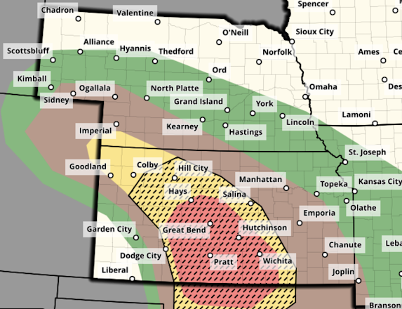
Let's begin with the national overview: The brown area has a significant risk of a tornado. The yellow area has an enhanced  risk The yellow, hatched area has an enhanced risk of strong tornadoes.  Here's a closeup of the highest risk area. This has been a very active weather pattern. I urge you to keep up on the weather on this region today. Important note: This will likely be my only forecast update today. I will provided limited  additional coverage on Twitter/X  @usweatherexpert.  I'm working on several time-critical, important projects that just cannot wait. 

Note to Readers...

This is the end of my tornado coverage for tonight. The main threat in many areas is now flooding.  I am working on an investigative report, so I don't know the blogging schedule may be tomorrow (Tuesday). Good night. 

Tornado Risk Today- Updated 2:15pm; 4th Tornado Watch

Image
-- original forecast, still valid -- Yesterday saw many tornadoes in the central Plains, several of which were strong. I believe we are in for another day of severe weather only this time a bit farther east.  Here is the color code for this forecast based on my 4-point scale. Note: the highest on my scale is an extreme risk which is  not  being forecast today.  Red, hatched =  high  risk of strong tornadoes.  Yellow, hatched =  enhanced  risk of strong tornadoes.. Brown = a significant risk of tornadoes.  Large or very large hail is likely over this same region. Damaging Winds The purple hatched area has a high  risk of wind gusts of 75 mph or stronger. The red area has an enhanced risk of wind gusts of 60 mph. The yellow area has a significant risk of gusts of 60 mph or stronger.  Safety Recommendations If you live in a mobile home or need a public shelter, you will find lists and maps  here . Please check it now, before ...

Tornado Forecast for Monday

Image
This forecast has been updated as of 8:45am Monday. Please scroll up for the latest tornado forecast.  Another day of dangerous tornadoes is forecast on Monday. It will be important to monitor the weather in the areas outlined below.  Here is the color code for this forecast based on my 4-point scale. Note: the highest on my scale is an extreme risk which is  not  being forecast Monday.  Red, hatched =  high  risk of strong tornadoes.  Yellow, hatched =  enhanced  risk of strong tornadoes.. Brown = a significant risk of tornadoes.  Large or very large hail is likely over this same region. Safety Recommendations If you live in a mobile home or need a public shelter, you will find lists and maps  here . Please check it now, before the threat of a tornado or extreme winds is imminent. If you have friends or family living in housing without an adequate tornado/extreme wind sheltering area, please give them a call and refer them to ...

Dangerous Tornado Day in the Central Great Plains - Updated at 1:10pm Sunday

Image
Below are the tornado forecasts valid from 2pm CDT through 3am CDT Monday. If you live in the affected areas, I recommend monitoring the weather in these area starting in the afternoon.  Noon Update: The "high" tornado risk area (red) has extended into the Wichita Metro, including Newton, Augusta, Winfield, Ark City and Wellington. If I lived west of I-135/I35, I would begin monitoring the weather by 2:30pm.  Here is the color code for this forecast based on my 4-point scale. Note: the highest on my scale is an extreme risk which is not  being forecast today.  Red, hatched = high  risk of strong tornadoes.  Yellow, hatched = enhanced  risk of strong tornadoes.. Brown = a significant risk of tornadoes.  Large or very large hail is likely over this same region. I note that there will likely be dozens of storm chasers out today.  1:10pm Update: There are solid indications that the more alarming thunderstorms will develop from just south of Dodge...

4:30pm Saturday, Note to Readers...

There are posts with the tornado forecast for the rest of the day, Sunday and Monday, and tornado safety rules just below these. 

Saturday's Tornado Forecast - Updated 4pm Saturday

Image
Tornado watch valid until 10pm. Note: this does not include the DFW Metroplex. It is covered by a lesser severe thunderstorm watch but it includes the forecast, "a tornado or two possible." -- original forecast, still valid -- The brown area -- which includes the DFW Metroplex as well as Oklahoma City and vicinity -- has a significant risk of tornadoes this afternoon and tonight. Please keep up on the weather in these areas.