Posts

Tornado Watch Until 5am Wednesday

Image
The area enclosed by red is likely to see tornadoes from now until 5am.  Rather than staying up monitoring the weather, sign up for StormWarn . It is the meteorological equivalent of a smoke alarm. It will ring your phones if you are in the projected path of a tornado. You can sign up here .

5:15pm Ian Update

Image
Update with 4pm Data This is the National Hurricane Center's 4pm forecast. They finally extended the hurricane warning  south to Everglades City.  There is now a storm surge warning and tropical storm warning along the Atlantic Coast from Georgia through South Florida. Here is the radar image of the eye of the hurricane at 5:13pm CDT. I believe the information below is still good except that it is a bit more likely the wind swath map needs to be moved south. ---- original posting --- Current Situation   -- 2:15pm 2:01pm satellite image. They Keys are at upper right in blue. This is the eye of a powerful hurricane and the colored symbols denote lightning around the eye -- which is a sure sign of additional strengthening.  Below is the radar image from 2:18pm which shows the eye of Ian moving north toward Florida. Its current wind speeds have increased to 120 mph (conservatively) with a central barometric pressure of 955 millibars. The storm will continue to strengthen...

Tornado Warning and Watch in Florida

Image
The tornado threat from Hurricane Ian have increased -- rapidly.  The red polygon is a tornado warning west of Miami. The time of this image is 1:33pm The tornado watch continues for the area outlined in red. Now is a perfect time to sing up for StormWarn . It is the "tornado version of a smoke alarm" and the fastest way to alert you when you are in the path of a tornado. No more staying up nights monitoring the weather when under a tornado watch. Check it out!

Update on Powerful Hurricane Ian

Image
Note: There is a newer update here .  -- original posting -- Below is an update as to the Ian's position and strength. This is a very dangerous hurricane that will cause a great deal of destruction and danger to life. It will rapidly strengthen this afternoon. 11:10am Tuesday: I have added elements of the 11am forecast package from the National Hurricane Center. See below: Ian has strengthened overnight to at least 125 mph winds with a minimum pressure of 950 millibars. The satellite pattern (not shown) and the radar are both impressive. Below is the latest image from the Key West radar. This is the 10:15am image. I predict the strengthening will continue when it is completely off the coast of Cuba.  Below is my forecast of where the eye will make landfall. Here is the 11am track forecast from the National Hurricane Center. They have finally moved their forecast to the south.  Below is what I believe is a reasonable wind pattern. It is important to remember it could shift...

9:05 pm EDT Update on Hurricane Ian

Image
[Please note: there is a more current update immediately above, click here . ] Here is the eye of Ian, which just became visible from the Key West NWS radar at 10:10pm. The thunderstorms making up the eye are just inside the white circle I added. UPDATE: Another alarming sign. The eye is clearing out just south of Cuba and, just to the west, lightning (red/orange dots). The latter is usual a sign of intensification. Photo from 10:25pm.  -- original post -- I wanted to get another update out before people retire for the night in Florida.  Below is the 8:54pm Ian satellite image. The above satellite image shows a strengthening hurricane with a central pressure down to 965 millibars. The maximum winds are around 105 mph. The strengthening may level off as Ian approaches western Cuba. Once it has cleared the Cuban land mass, I expect rapid strengthening and that the National Hurricane Center's 140 mph peak wind forecast to occur.  My forecast of where the eye will cross the c...

Considerable Tornado Risk in Florida

Image
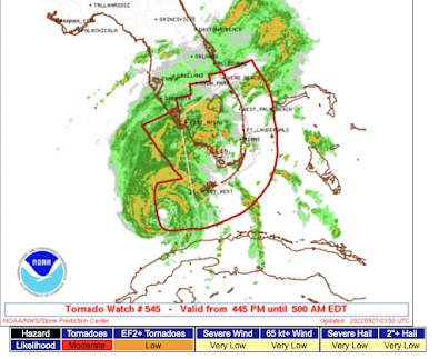
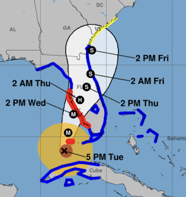
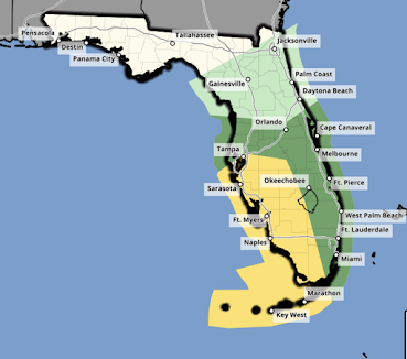
Here is the tornado forecast for Florida for Tuesday: And, the forecast for Wednesday: There is a serious risk of tornadoes in the yellow areas and a lesser risk in the dark green areas. On Thursday, the tornado risk will move into northern Florida and, possibly, southern Georgia.  Tornadoes associated with hurricanes form very quickly -- often faster than the tornadoes associated with supercell thunderstorms in the Midwest and South.  Therefore, to protect your family, get StormWarn . It is the fastest way to get warnings 24/7. They come through two phones of your choice such as your landline and cell or your cell and the cell owned by your spouse. No more staying up late at night to monitor the weather when tornadoes are in the forecast.  In additional to the telephoned warnings, you get an instant email with the location of the storm on radar and the specific location of your home (or other area for which you get a subscription).  StormWarn is the perfect way to p...

5:05pm Monday EDT Hurricane Ian Update

Image
Hurricane Warnings for the Florida Coast Here is the current position of Hurricane Ian as shown by Grand Cayman radar at 4:30pm EDT. Here is the National Hurricane Center's 5pm EDT track forecast and warnings. The storm currently has a central pressure of 965 mb and a peak sustained wind of 105mph  (in red, updated at 7pm). The storm is strengthening and will continue to do so. The storm is forecast to strengthen to peak winds of 140 mph between Cuba and Florida.  Red = hurricane warning Pink = hurricane watch Yellow = tropical storm watch Blue = tropical storm warning Amber = tropical storm force winds now Brown = current hurricane force winds There is a very real danger of Ian slowing down near Tampa which would cause a severe storm surge (see map below).  This is a map of the forecast wind swath for Ian. One hundred mile per hour winds are likely at the mouth of Tampa Bay. Offshore, winds will be 130 mph. There will be a highly dangerous storm surge in western Flo...