Posts

Showing posts with the label winter weather

New Photos Added to Our Collection

Image
We've added new photos to our collection at Adobe Stock Photography . We have a variety of winter-themed photos (two below)...... .... and a wide variety of photos from other seasons and conditions.  So please check out our collection anytime you may need photography for your project. 

Colorado: Late-Season Winter Storm Warning

Image
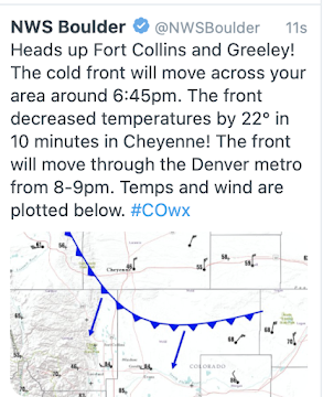
As of 7:17pm, a cold front was sweeping into the Front Range that will bring a record cold spell. Note the temperature dropped 22° in ten minutes. Here is a map of all of the weather warnings across the region for Friday. The winter storm warning includes Denver. It is likely  in the Foothills and possible in the City of Denver that leafed-out trees will be seriously damaged by the storm. Sagging limbs may cause power failures . Please prepare accordingly! WWA = winter weather advisory, which is a lesser condition than a winter storm warning.  Below is a map of forecast snow amounts from CBS4 in Denver . Great info from the Denver NWS are here .  UPDATE, 8:50pm CDT. If you know someone camping in Rocky Mountain National Park, tell them to leave immediately. Some of the new models are forecasting higher amounts of snow than the above. If that occurs, they could be trapped or injured due to falling trees. Rescue might take some time. Get out now!

Are We Being Deliberately Set Up For a Winter of Torment?

Image
Texas: Valentine's Week 2021 This is an report I believe is important and, for which, I have done two weeks of research. Allow me to state up front: I hope I am too cynical and wrong in my predictions. But, if I am correct about the weather this winter,  conditions could get very bad. In this piece, I will explain the reasons for my concern and what we should do to prepare.  The Convergence of Problems in America To set the stage, please recall the extreme cold during Valentine's Week 2021. There were extreme issues in Texas with lack of electricity and natural gas, unheated homes, hospitals and businesses; more than seven hundred  deaths, and economic losses north of $100 billion . You may have forgotten that many areas outside of Texas had blackouts due to an insufficient supply of electrify.  Fast forward to today: In Wichita, where we live, we are starting to see empty shelves in grocery, hardware and big box stores. Restaurants are cutting hours and menu items. ...

Protecting Pets in Extreme Cold

Some great Kansas ingenuity . I highly recommend the article and her clever solution.

Dickens Winters

This week marked the 200th anniversary of the birth of the great Charles Dickens. Meteorologists are familiar with the phrase "Dickens Winters" to mark the extraordinary cold the prevailed during his lifetime, which took place during the Little Ice Age. You can read more about Dickens Winters here . Anyone want to go back to those temperatures?

Dickens Winter

This week marked the 200th anniversary of the birth of the great Charles Dickens. Meteorologists are familiar with the phrase "Dickens Winters" to mark the extraordinary cold the prevailed during his lifetime, which took place during the Little Ice Age. You can read more about Dickens Winters  here . Anyone want to go back to those temperatures?

Major Weather Pattern Change?

Image
For most of December and January, the wind flow in the upper atmosphere has been from east to west west to east across North America as shown with the thin black lines on the 18,000' wind map from this morning: The deep purple is the extraordinary cold (even for winter) in Canada. The 10-day forecast from the European Center for Medium Range Forecast shows a major change in pattern very wet weather in the West and the potential for some of the very cold air to come south in about 14 days. Stay tuned.

The Cold Blast to Start 2012

Image
After Wichita reached an incredible 66° on New Year's Eve, points east of Wichita will start the year with cold and windy conditions. And, some spots near the Great Lakes will have blizzard conditions with Lake Effect snow.   AccuWeather has the details. The lake effect situation is now starting to set up per AccuWeather's regional radar from 11:30am.

Windy End of the Year

Image
The amber color = high wind warnings. Gusts above 60 mph are already being reported in Colorado and they will spread rapidly as a cold front moves across the region.  The magenta color = high wildfire danger. Near the Great Lakes are pink = winter storm warning and blue = winter weather advisory.

Topsy-Turvy White Christmas

Who has had more more snow this season than Chicago + Boston + New York + Buffalo combined? Answer: Midland, Texas. The town, in southwest Texas, is suffering from a severe drought but the recent unusual weather patterns have brought more than usual snowfall. Hat tip: AccuWeather .

Today's Storms

Image
We have a tornado watch in effect until 1pm in Mississippi and Louisiana: The strong thunderstorms are expected to spread east today. This is the tornado probability with the brown-tint an area where you should keep up on the weather. Note it includes Atlanta -- and the Atlanta Airport. In the Rockies and High Plains, it is snow. Denver has received 7" of snow and parts of Boulder County north of Denver more than a foot. There are 1 hour, 15 minute delays at Denver International Airport. This will be a regional storm affecting mostly Colorado and New Mexico. Amounts out into the low Plains will only be an inch or less.

Quick Travel Update

Image
Here are the snow depths as of 7am: From NWS, click to enlarge Roads are closed throughout the western third of Kansas, including I-70 west of WaKeeney along with much of southeast Colorado, northeast New Mexico (including I-25 into southern Colorado), and the western Oklahoma Panhandle. The snow has stopped in these areas so conditions should start to improve this afternoon. The snow has not stopped falling farther east. Here is the AccuWeather regional radar from 9:45am: And, here is the forecast additional accumulation from 7am (the time of the map above) to 9pm CST, which should be the ending time of this storm. Another 2-3" will fall along I-70 in central Kansas where it is still open, but is already snowpacked. Believe it or not, there is another storm behind this one for the Central third of the U.S. plus the East may receive some snow by Christmas . This is the last forecast I'm going to post on this storm. Tomorrow when the final figures are in, as is cust...

Winter Storm Progress

Image
Here is the current list of warnings: Blizzard = orange. Pink = winter storm. Blue are winter weather advisories (a less erious condition). And, here is the AccuWeather regional radar. The rain is now starting to change to snow along the southern Colorado-Kansas border as the storm moves east.  Thunderstorms are continuing to bring beneficial moderate to heavy rains in the southern High Plains. Severe thunderstorms with a tornado threat will exist later this afternoon and tonight in a broad band from Dallas to Houston.

An Amazing New Tool

Image
You often hear of "black ice." One form of black ice can form when fog deposits ice directly on roadways without precipitation falling from the sky. That is known as "freezing fog." A new type of satellite image depicts previously hard-to-detect freezing fog in shades of orange and red. Here is an example showing the freezing fog in the tough terrain of the Pacific Northwest. University of Wisconsin, click to enlarge More progress. This data will allow us to help keep traveling safer through better monitoring of dangerous conditions.

AccuWeather's Winter Weather Outlook

Image
Details here .

Good News: More Moisture. Bad News: Winter

Image
A very slow moving low pressure system in the upper atmosphere predicted to linger over the Southwest is going to bring much-needed moisture to the region. Here is the precipitation amount forecast for the next ten days (via AccuWeather's professional site, this is the European model): click to enlarge And, a significant amount of the moisture is going to fall in the form of snow. The graphic below are the probabilities of one inch or more of snow accumulation: 6pm Wednesday to 6pm Thursday 6pm Thursday to 6pm Friday And, even heavier and more widespread snows will likely spread into the Plains Friday night and Saturday. By Sunday morning, most of the Nation west of the Mississippi will be colder than average -- in some areas much  colder. Winter is coming!