Posts

Showing posts with the label satellite interpretation

High Resolution Satellite Image of NY-Area Snow

Image
Click to see full resolution image. Taken by NASA earth observing satellite earlier today. Whiter = heavier snow cover. The unfrozen Hudson River shows up nicely from top center south to where it empties into New York Harbor down the west side of Manhattan. ADDITION: 4 million are now said to be without power.

An Amazing Forecast - Meteorology Does it Again

Image
My mentor, Don Whitman, a forecaster with the National Weather Service, taught me the importance of getting the forecast of the first snow of the season correct. As Don used to say, "If you get the first one wrong, people remember it all winter." The challenge is that temperatures are often marginal during the first snow of the season so it has always been especially difficult to get the first snow of the season right.   So, it is amazing how good the forecasts were of the just-ended record snow storm in the East.  AccuWeather started talking about it Thursday and I posted about the pending storm on this blog Friday at 8:57am -- about 22 hours before the heaviest snow began falling.  Hat tip: AccuWeather's Jesse Ferrell; click to enlarge Later Friday, I (along with others) posted: "widespread power failures are likely." I also posted, "Just in case, here is my Airline Survival Guide ." Rule #1 in the Guide is to avoid the problem by not flying i...

Satellite View of Massachusetts Supercell

Image
This is about the time the tornado was forming in the thunderstorm indicated by the arrow. The thunderstorm was near Springfield, Mass. NASA photo, click to enlarge.

Brown Gashes on an Otherwise Green Earth

Image
You'll want to click to enlarge this image. This from the AQUA earth-monitoring satellite. These tornadoes were so large they left visible brown gashes on the Alabama countryside. To help you find the gashes, storm chaser Aaron Kennedy  put yellow lines parallel to the tornado's tracks. I have added the arrows.  The city of Tuscaloosa is between the "a" and my first arrow. The path across Birmingham was largely covered by clouds when the satellite passed over. ADDITION: Excellent photo coverage from The Boston Globe .

Climate Satellite Versus Bureaucracy: Bureaucracy Winning

In Warnings,  when I am telling the story of Katrina, I explain how bureaucracy -- literally -- killed hundreds. Now, it is killing a vital satellite for climate monitoring. The depressing story is here .

Japan Before and After, Via Satellite Image

Click here to go to a New York Times  interactive graphic. Move the blue slider right and left to see before and after.

Big Storm Coming! The Question is Where

Image
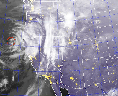
I'm getting LOTS of messages tonight about the forecasts for a big storm. I advise people not to pay too much attention to winter storm forecasts until about 48 hours before the storm is expected to start in your location.  The big snows are still more than 48 hours away from the central U.S. so I haven't made a forecast. I just re-posted this image and circled the location of the low pressure system for non-meteorologists reading the blog. If you are wondering why we can't pin it down yet, it is because the storm is still not over land. The center of the storm is the inner-most "comma-shaped" cloud band off the coast of Northern California. It seems that until the storm can be sampled by the land-based weather balloon network, the forecasts tend to be very inconsistent.

Weather Satellite Interpretation 101

Image
People often view weather satellite images, but don't get the full value from them.  Here is a primer based on two recent images. Saturday, we had crystal clear skies over Wichita (image courtesy NWS). The white is the snow cover from the Thursday-Friday storm. You can tell it is snow cover because you can see lakes and other geographical features. Generally, the whiter colors equal greater snow depths. Right now, we have fog enshrouding Wichita with some higher clouds above the fog.  The high clouds are discernible because they cast shadows on the lower fog.  The fog (keeping in mind fog is just a cloud on the ground) is distinguishable from the snow cover because it is absolutely featureless.  No lakes, no shades of gray.