Posts

Showing posts with the label giant hail forecast

11:48am Severe Thunderstorm & Tornado Update

Image
Watch Issued, Including the Kansas City area Extensive  power failures in central Kansas with the line of thunderstorms moving east. There hav been several tornadoes.  I am posting updates @usweatherexpert  on Twitter/X Below is another view of the radar and watch as of 11:45p. Tornadoes Possible,  75 mph Gusts and 2" Hail Possible Tornadoes Possible, 85 mph gusts,  softball-size hail till 1am.  Second Tornado Watch, Includes  Denver First Tornado Watch of the Day Please note that in addition to tornadoes, softball-sized  hail is forecast along with widespread  90 mph gusts. If this forecast is correct, power outages will also be widespread. Tornado Forecasts Update in tornado forecast for Kansas.  5:05p: I would add McPherson, Marion, Chase and all of Lyon County into the "significant" area. The brown areas have a significant risk of tornadoes. In the hatched areas, the tornadoes could be strong.  Damaging Wind The red area has an ...

Monday's Tornado Risk - Preliminary Outlook

Image
The NWS is forecasting the potential for violent tornadoes over southeast Nebraska and in a band from northeast into south central Kansas.  The possibility exists for tornadoes from Wisconsin to northwest Texas.  The area where the most violent tornadoes are forecast to occur is the area with bold diagonal hatches from southeast Nebraska, into extreme northwest Missouri and into south central Kansas.  The dashed hatching is where strong tornadoes are forecast to occur. In the red area, there is a high  risk of tornadoes In the yellow area, there is an enhanced risk of tornadoes. In the brown area, there is a significant risk of tornadoes.  If I lived in the highest risk area, I would prepare by making sure my car can be put in the garage and I would bring in lawn furniture. I'd also go to the ATM and get some extra cash, if possible.  Finally, make sure your storm shelter area is ready to go. Always wear shoes, have a couple of bottles of water and some dia...

10:50pm Update: First of Three Dangerous Weather Days

Image
Three Straight Days of Dangerous Storms For Saturday and Saturday Night 10:50pm Tornado watch until 5am. This includes Dallas and Ft. Worth 5:35pm Radar at 5:30pm. Gold counties = tornado watch. Pink counties = severe thunderstorm watch.  4:20pm Update The red tint is the tornado watch which calls for "intense" tornadoes, 4" in diameter and thunderstorm-generated winds of 80 mph. As of 4:15pm, thunderstorms were beginning to develop in the southwest part of the watch.  I will not be able to provide my continuous coverage this afternoon, so please monitor trusted weather sources.  11:45am update There is an enhanced  risk of tornadoes in the yellow area and any tornadoes could be strong. Update: the solid cross hatching is where the NWS is forecasting violent  tornadoes.  The brown area has a significant risk and there, too, the tornadoes could be strong. The primary threat should be after 3pm.  This the hail forecast. Where you see the bold cross-hatch...

Giant Hail and Tornadoes (?) Forecast by the NWS

Image
I'm passing this severe thunderstorm watch along because of the forecast of 75 mph gusts and hail to tennis ball size. However, I do not see much of a tornado threat. Nevertheless, I could be wrong so keep an eye out if a strong thunderstorm moves into your area. 

High Risk of Large Hail

Image
The above forecast is from the NWS Storm Prediction Center and the yellow area has an enhanced risk of hail 1" or larger with the hatching where 2" or larger hail is forecast. However, two additional techniques show a higher risk of large hail in north central Kansas, so I thought I would provide this additional information view the red outline. 

Today's Tornado Forecast: Midwest

Image
There is a significant risk of tornadoes -- and some could be strong -- in the brown hatched area.  Below is the forecast for damaging winds and large hail. The red area has an enhanced  risk and the yellow area has a significant risk. The hatching means winds may exceed 75 mph and hail size may exceed two inches. 

Giant Hail Threat

Image
Within the hatched area, there is a significant risk of hail 2" in diameter or larger. Might be a good idea to put your car in the garage, the bar-b-que and lawn furniture inside, et cetera. All of these could be damaged by hail.

Today's Tornado Risk - Updated 8pm

Image
7:55pm A tornado watch is now in effect until 1am. Please note that tennis ball-sized hail and 80 mph thunderstorm-generated gusts are forecast.  3:20pm Kansas:  As of 3:10pm, a line of tower cumulus clouds is growing along the dry line in Kansas. I expect thunderstorms to form along the dry line by around 5pm (give or take). These storms may produce large hail this evening near and southeast of the Kansas Turnpike.  Later tonight, a cluster of storms with damaging winds is likely from SE Kansas and Oklahoma into Missouri. You may wish to bring in trampolines and outdoor furniture that could blow about.  Oklahoma:  No tower cumulus yet but when/if thunderstorms develop, they will grow very quickly and could become quite severe.  --- original posting (still valid) --- The NWS Storm Prediction Center has added a significant chance of tornadoes in a part of Oklahoma this afternoon and evening.  As Norman and Stillwater, as well as OKC and Tulsa, are inclu...

This Evening's Tornado Risk - Updated

Image
In addition to tornadoes, here is also an enhanced risk of hail 2" in diameter or larger in the yellow area.  As of 4:50pm, the first thunderstorm is forming on the border south of Bismarck. Please monitor the weather the rest of the evening!

[Updated] Thursday and Friday Tornado and Severe Thunderstorm Risk

Image
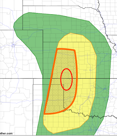
Thursday and Thursday Night Forecast The yellow area has a significant risk of tornadoes and severe thunderstorms (large hail and damaging thunderstorm-generated winds). The orange, hatched area is where there is an enhanced risk  giant hail and tornadoes are more likely. The red oval is where I believe there is a higher risk of tornadoes, especially Thursday evening.  Update:  The NWS has updated their forecast for Thursday and it is below.  Their red area is very similar to my orange area. However, they pull their higher risk area to include Hutchinson and Pratt and it is close to Wichita. Where you see red + hatching in their forecast there is an enhanced risk of strong tornadoes and  hail 2-3" in diameter. Elsewhere, where you see the hatching, there is a risk of tornadoes but the primary risk is hail ≥ 2 inches.  With the potential for strong tornadoes, it is important to monitor the weather Thursday (and Friday, see below). Of course, I will...

High Risk of Tornadoes and Giant Hail - UPDATED 1:50pm

Image
Thunderstorms are now developing west and northwest of Oklahoma City. These are the storms that will move into north central and northeast Oklahoma -- which are anticipated by the forecast immediately below. The radar time is 1:47pm.  Note: You will find locations of community shelters, here .  ---- forecast below still valid --- I have updated the forecast for tornadoes this afternoon and tonight. This is a serious situation. Please make sure your friends and family are aware, especially in the higher risk areas.  Tornado Forecasts There is an area of high  tornado risk over parts of Kansas, Oklahoma and Missouri that are outlined in red.  Late model information indicates the area of enhanced risk has grown on the south end as compared to the earlier forecast.  Giant Hail Forecast This is an updated forecast (11:30a) hatched area is where hail 2" or larger is forecast by SPC to fall. The higher probability (an enhanced  risk) is in the area in red. Th...