Posts

Showing posts with the label Indiana

'Green' Energy: Gone With the Wind!

Image
If a tornado and a solar farm combine in space and time, who wins? Yes, your guess is correct.  This was a solar farm in Indiana. AccuWeather has the video. It was truck Tuesday night and its location was (ironically) Wheatfield, Indiana. All nuclear plants are tornado-proof and many/most natural gas and coal plants are tornado-resistant. The tragedy here isn't just the damage to "green" energy -- it is the pollution from this damage leaching into the soil -- making it unsuitable for agriculture.  It is worth pointing out again that until 2023, the United States was self-sufficient in food starting in 1776. We no longer are. Which would you rather have: food or solar energy?? 

Inadequate Warning of the Kankakee Tornado - 9:15pm Update

Image
NBC Chicago Undoubtedly Wednesday morning, you will be hearing about the tornado which struck the Kankakee, Illinois, area (south of Chicago) around 6:25pm. The damage is considerable. Chicago's WGN-TV says, "Kankakee County was severely damaged." There is report of two people killed by this tornado across the border in Lake Village, Indiana.  After the poorly warned tornadoes in southwest Michigan Friday, one would think the NWS would have made it a point to have its radars operating on optimum settings and then jump on any supercell thunderstorm with tornado characteristics. It appears this did not happen in Kankakee.  Below is what I posted on Twitter/X at 6:04pm. I do not use the term "tornado warning" as I believe it should be reserved for the National Weather Service (NWS) which is the official warning source.  Unfortunately, we did not hear from the NWS regarding the tornado threat for quite a while. While a severe thunderstorm warning for "softball ...

Travelers: Beware of Chicago Through Tuesday - Updated 5:40pm CST

Image
What may be a record November snow event has just begun. This will unquestionably affect O'Hare and Midway (not to mention the issues with air traffic control due to the government shutdown) and may affect Amtrak.  Updated Snowfall Amount Forecast Current conditions in South Bend by Connor Croft. --- original post --- The area in pink has a winter storm warning. Purple is a winter weather advisory (lesser condition). The area around Waukegan has a winter storm watch. Thundersnow is possible.  As much as 18 inches  with drifting is possible. Please factor this into your travel plans. 

12:55pm Update: Midwest Enhanced Tornado Risk

Image
12:55pm College of DuPage Graphic The risk of tornadoes and wind gusts of 75 mph are ramping up in the area outlined in red. Several confirmed tornadoes have already occurred. I urge you to monitor the weather in this area the rest of the afternoon and into this evening.  Tornado watch issued.  In addition to tornadoes, wind gusts of 75 mph are possible. Please monitor the weather through this evening if you live in the yellow-shaded areas.  --- original post, forecast still valid --- The yellow area has an enhanced  risk of tornadoes this afternoon and evening. The brown area has a significant risk.  Please keep up on the weather -- especially if you live in the yellow area -- the rest of the day. 

"Catastrophic" Flooding By Saturday Evening

Image
I stayed up to get you the latest rainfall amount forecast for the next 48 hours (12:30a Friday).  Yes, that is another 7-9 inches in the amber area from now until 7pm Saturday evening. Catastrophic flooding is forecast by the National Water Center in a band from Ft. Smith and Mena to Louisville.  If you live in an area which has flooded before, it will likely do so with this "historic" (NWS) flood event. It is necessary to be able to leave on short notice if an evacuation is ordered or if you observe rapidly rising water. Keep in mind the 100% cause of flood deaths is driving or walking through a flooded area.  If you are a logistics manager, forget about getting long haul shipments via truck or rail through this region the next few days. 

Strong Tornadoes Forecast Today - Updated 5:55pm

Image
7:40pm CDT This is where the highest chance of tornadoes exists the rest of the evening until 1am CST. Note: This ends my coverage for the evening. Thank you for reading.  5:55pm CDT Watch is in effect until 1am EDT. Note that "strong" tornadoes are forecast to occur.  2:40pm This is the area about which I am most concerned when it comes to tornadoes, especially from southern Illinois to Arkansas.  Reminder: I provide additional coverage on Twsitter/X @usweatherexpert .  1:20pm Tornado Watch, Includes Chicago 12:10pm - Tornado Watch This is the first tornado watch of the day. Note also that hail to 2" and 70 mph wind gusts are forecast to occur.  Now is the time to make sure, if you live in a mobile or manufactured home, to know where the nearest public shelter is  located. You will find a national list and map here .  Tornado Risk The yellow, hatched area has an enhanced risk of strong tornadoes. The brown area has a significant risk of tornadoes. ...

Second Tornado Watch Issued

Image
Second Tornado Watch First Tornado Watch Tornado watch in effect for "a couple of strong tornadoes" from now until 7pm CDT. It includes the south part of Chicagoland, the Quad Cities and western Indiana. Please monitor the weather the rest of the day! I am providing real-time updated information on Twitter @usweatherexpert.  --- Tornado Forecast Until 7am CDT --- The yellow, hatched area has an  enhanced risk of strong tornadoes this afternoon and evening. The brown area, which includes Chicago and the Quad Cities, has a significant risk of tornadoes. With the 11:10 update, Ft. Madison and Dubuque have been added to the brown area. In the meantime, please make sure your shelter area is cleaned out and read to go with a couple of bottles of water, shoes (if your home is hit you don't want to walk barefoot on debris), and diapers if appropriate.  If you live in a mobile home, it is important to find other shelter. If you do not have friends or family in a nearby conventiona...

3:20pm EDT Update -- Tornado Watch Issued

Image
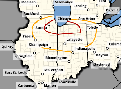
Tornadoes are likely  in this region. Please monitor the weather throughout the late afternoon and evening.  --- original ---  There is an enhanced  risk of tornadoes in the orange area with a significant risk of tornadoes in the yellow area.  Please keep an eye on the weather in this area. 

Tornado and Severe Thunderstorm Forecast for Tuesday

Image
It looks like tomorrow will be a major tornado and severe thunderstorm day in the Midwest. I recommend people start planning accordingly. There is a high  risk of damaging storms. Tuesday's Tornado Risk There is an enhanced risk of strong tornadoes  in the yellow, hatched area. There is a significant risk of tornadoes in the brown area.  Tuesday's Damaging Wind Risk Here is the color code for this forecast: Purple: a high risk of wind gusts of 75 mph or stronger. Red, hatched: there is an enhanced  risk of wind gusts of 75 mph or stronger.  Red (only): an enhanced  risk of wind gusts of 60 mph or stronger.  Yellow: a significant risk of wind gusts of 60 mph or stronger.  There is also the risk of large hail in the above areas. A derecho may occur. Please factor this forecast into your plans Tuesday and Tuesday night.  Yesterday's forecast , unfortunately, worked out pretty well. It is almost certain there were more tornadoes in Kansas than sh...

Today's Tornado Risk

Image
The area in brown has a significant risk of tornadoes. There is also a better than average chance of damaging thunderstorm-generated winds.  This hail forecast is the probability of 1" diameter hail or larger. The area in red has an enhanced risk  of large hail. The yellow area has a significant risk. Where the hatching exists, the hail could be 2" or larger.  I will update the forecast this afternoon. 

Tornado Watch Illinois, Indiana, Ohio, Kentucky

Image
The tornado watch is in effect until 6am EST. Please monitor the weather over this region the rest of the night. Turn on your weather radio, WEA or your GPS weather app. I am also tweeting  @usweatherexpert. 

Tornado, Hail, and Wildfire Forecast for Tuesday [Updated, 4:45pm]

Image
There is a significant risk of tornadoes tomorrow in the Midwest after about 4pm. The first of the severe thunderstorms will probably develop over Illinois. The area in orange has a significant risk of a tornado. The area in red, which includes Chicago, has an enhanced risk.  There is also a risk of giant hail -- two inches or larger -- in the hatched area. In the remainder of the yellow area, there is a significant risk of 1" or larger hail. There is also a critical wildfire risk of wildfires in the red area over the southern High Plains.  Of course, I will update on these risks tomorrow.