Posts

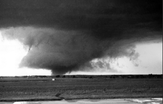
Gaylord, Michigan Struck By Strong Tornado

Image
NWS's Warning For This Tornado Was Inadequate The date of May 20 is one of the infamous in tornado history . Unfortunately, we are going to have to add another tornado to the list -- the one that occurred this afternoon in Gaylord, Michigan.  8:25pm Friday Update: At 11am pm Saturday, there are two fatalities, 44 injuries and one person missing according to the Detroit News. While the damage reports are just starting to come in, the storm appears to have been EF-2 to EF-3 intensity as a rough estimate. I have not seen a report as to injuries . Note: NWS rated the storm EF-3 intensity -- a "strong" tornado.  Photos: Michigan State Patrol except for screen capture which is The Weather Channel's This morning's blog post included National Weather Service's (NWS) Storm Prediction Center's forecast of a "significant" (my term) tornado risk for northern Lower Michigan.  Unfortunately, the forecast and warning quality went downhill from there.  A severe ...

Today's Tornado Risk

Image
The brown areas have a significant risk of tornadoes later today. Please keep up on the latest weather information. 

May 20th - Tornado Anniversaries

Image
Ruskin Heights 65 years ago this evening was the Ruskin Heights Tornado (F-5) which launched my career in meteorology. The photo above (used with permission) was when the tornado was near Ottawa. It was on the ground nearly 80 miles with the south of the Kansas City area comprising the last 20 miles. Forty-four people were killed and about 500 injured. It was the first time what we would, today, consider a tornado warning was issued by the government.  Codell The town of Codell, in north central Kansas north of Hays, was a prosperous community at the turn of the 20th Century. One hundred five yers ago today, was the middle of three freaks of nature: the town being hit by tornadoes on May 20, 1916, May 20, 1917 and May 20, 1918. In 1977, Weatherwise  magazine published an article I wrote (above) about the history of the torn and its tornadoes.  The worst of the tree was the last: Ten people died in the area. Below is a photo of the destroyed high school after the last of t...

Colorado: Late-Season Winter Storm Warning

Image
As of 7:17pm, a cold front was sweeping into the Front Range that will bring a record cold spell. Note the temperature dropped 22° in ten minutes. Here is a map of all of the weather warnings across the region for Friday. The winter storm warning includes Denver. It is likely  in the Foothills and possible in the City of Denver that leafed-out trees will be seriously damaged by the storm. Sagging limbs may cause power failures . Please prepare accordingly! WWA = winter weather advisory, which is a lesser condition than a winter storm warning.  Below is a map of forecast snow amounts from CBS4 in Denver . Great info from the Denver NWS are here .  UPDATE, 8:50pm CDT. If you know someone camping in Rocky Mountain National Park, tell them to leave immediately. Some of the new models are forecasting higher amounts of snow than the above. If that occurs, they could be trapped or injured due to falling trees. Rescue might take some time. Get out now!

Paths of St. Louis / Bi-State Tornadoes

Image
We had a number of rotation paths that may have produced small tornadoes in the St. Louis -  Bi-State area earlier this evening.  Rotation path map. Red-White-Blue > chance of an actual tornado At lower left, the circle shows the rotation around Leslie, MO where a tornado occurred this afternoon.  In the Bi-State area, the arrows indicate the rotation paths over the area. Because the storms were moving so quickly (50+mph), the paths are not as precise as usual. From radar, it would appear the most significant rotation was between Ladue and Olivette and up the river from just east of Lemay to downtown.  UPDATE 9:15pm: NWS graphic of the path of the Kirkwood Tornado, which corresponds to the easternmost of the cluster of 3 arrows.  These situations are really difficult because they feature quick spin-ups and the NWS had the radar on 3.5-minute mode, so some of the spin-ups occurred between radar scans. I wish more NWS would go to the 1.3-minute mode in tornado ...

Today's Tornado Risk

Image
The brown areas have a significant risk of a tornado, along with the potential for damaging thunderstorm winds this afternoon and tonight. 

No Question!

Image