Posts

Heads Up: Louisiana, Mississippi and Alabama

Image
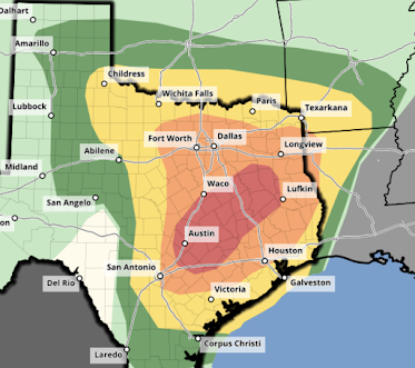
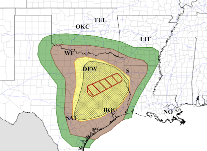
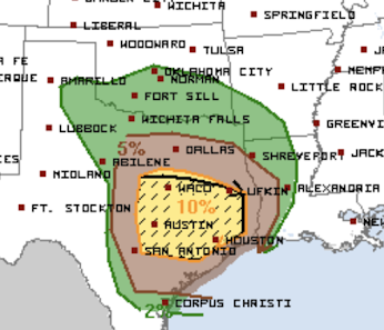
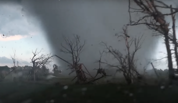
Tomorrow will be another day with a major tornado threat.  There is a high risk of strong tornadoes in the red area. There is an enhanced risk of strong tornadoes in the yellow area.  There is a significant risk of tornadoes in the brown area.  This forecast is valid from 7am Tuesday to 7am Wednesday.

High Risk of Strong Tornadoes Through Tonight

Image
Dangerous Tornado Situation  Later  This Afternoon and Tonight   I'm really concerned about this one: strong tornadoes are going to occur in the hatched area.  High  risk of strong tornadoes in the red area  Enhanced risk of strong tornadoes in the orange area. Significant risk of tornadoes in the yellow area.  Note: it is quite likely that strong tornadoes will occur after dark in east Texas and, perhaps, northwest Louisiana.  Preparation recommendations here .  Here is a quick sheltering reminder: Finally, there is a moderate risk of flash flooding tonight in the red area outlined below.

Dangerous Tornado Risk This Afternoon and Tonight

Image
Dangerous tornado situation this afternoon and tonight.  Here are the risk categories: The red hatched area is where there is a high  risk of strong tornadoes. This includes the overnight areas. The hatched yellow area has an enhanced risk of strong tornadoes.  The brown area has a significant risk of tornadoes.  Also: In the yellow area, there is a likelihood of giant hail ( ≤ 2" diameter).  Now is the time to prepare. Recommendations are here . 

Flash Flood Threat Monday Night and Tuesday

Image
In addition to the tornado threat, there is a flash flood threat in a stripe from near Bryan, Texas to near Greenville, Mississippi, during the next 48 hours. There is a chance a few spots in the heavy rain stripe could receive as much as 7 inches.  Note: Needed rains are forecasted for the winter wheat belt. 

Dangerous Tornado Situation Monday Afternoon Through Tuesday Night

Image
Above is the tornado threat from noon Monday to 7am Tuesday. As defined on my four-point scale: There is a significant risk of tornadoes in the brown area. This includes Dallas and San Antonio. There is a high  risk of strong tornadoes in the hatched yellow area. This threat was kicked up a category because of the likelihood of tornadoes after dark. This includes Austin and Houston. The tornado threat continues all day Tuesday and into Tuesday night.  The hatched area has a high  risk of strong tornadoes from 7am Tuesday to 3am Wednesday. The probabilities on this map are of all  severe weather categories (tornadoes, large hail, damaging thunderstorm winds).  Below is a list of things to do to get ready now . Please review it. 

Essential Tornado Safety Recommendations

Image
Basehunters Unfortunately, it looks like we will see tornadoes -- some violent -- from Texas into the South Monday into Wednesday. Overnight  tornadoes are likely Monday night and throughout the day into Tuesday night. It is critical that you be prepared to receive tornado warnings from multiple sources.  I offer this advice for those in Texas and the South the next 72 hours and for everyone for this tornado season.  Wireless Emergency Alerts (WEA) These are available from your smartphone. While they sometimes suffer from reliability issues (thus the reason for use of multiple sources), they have the advantage of being able to awaken you during the night if you place your smartphone next to your bed.  If you haven't already activated WEA, here's how to do it for an iPhone.  1. Go to "Settings" and Scroll Down to Notifications. 2. After tapping "Notifications" scroll all the way down to "Emergency Alerts." Turn them On.  Other Warning Sources There ...

Sunday Fun: Just in Time for Tornado Season

Image
This from a new business in Wichita. So, next time we are under a tornado watch and you are hungry.....