Posts

Review of Winter Storm Forecast

Image
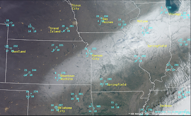
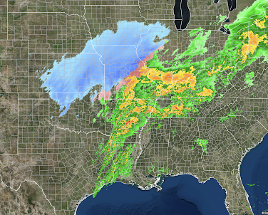
Satellite photo of the snow cover: The number at upper left from each circle is the temperature. Note how it is colder over the (white) snow cover.  Below is a map of snow amounts from the recent winter storm You can see the effects of snow thunderstorms between Wichita and Emporia with the highly variable amounts. And, below is the forecast of snow amounts.  Blizzard conditions occurred from Kansas to Illinois which were implicated in the 100-vehicle wreck in Illinois.  Snow thunderstorms are extremely difficult to forecast and they occurred in multiple locations in Kansas and western Missouri.  In all, I think you'll agree this was an excellent forecast. I don't write that to boast but to point out that, as recently as the day before (Wednesday), I was receiving comments expressing quite a bit of skepticism pertaining to the snow forecast. Modern meteorology is a wonder of weather science, physics, math, technology and the training + experience of meteorologis...

Heads Up: Serious Flooding Threat

Image
Here is the forecast rainfall for the next seven days. As much as seven inches is forecasted to fall in eastern Tennessee. The entire five inch area (orange) will see at least some flooding. Please keep up on local weather sources. 

Additional Snowfall From 2pm Thursday to 7am Friday

Image
This is the forecast snow from now until 7am CST Friday.  This is the last forecast for the current snow storm. 

Tornado Watch Just Issued in the South

Image
Tornado watch till 6pm for Arkansas, Louisiana, Tennessee and Mississippi. Strong tornadoes are possible. Please monitor local weather as storms develop in this area.  Overall, there is a significant risk of tornadoes in the brown area. The yellow area has an enhanced risk and the hatching is where strong tornadoes are forecasted to occur between now and tonight.  This will be my last tornado forecast  of the day.   I will post an update late this afternoon. 

Lightning + Sleet + Train

Image
Screen capture at 12:26am this morning of lightning over southwest Wichita, sleet (the vertical smudges) and an approaching train (the bright white lights down the tracks). This image is from the Virtual Railfan camera in Wichita. 

Winter Storm Update

Image
Above is the 9am radar. Blues = snow with the darker blues meaning heavier rates of falling snow.  Blizzard conditions exist along the Kansas Turnpike from just south of Topeka to Wichita, including the Flint Hills as winds are gusting to 40 mph.  Driving through the region is extremely hazardous and should only be undertaken if there is no other choice.  Below is additional  snowfall forecasts through midnight. 

Today's Tornado Forecast

Image
The brown area has a significant threat of tornadoes.  The yellow area has an enhanced threat. Where it is hatched means strong tornadoes could occur.  Please keep up on the weather information through the day in these areas.