Posts

You Can Find Frequent Weather Updates on Twitter...

 ... just go to @usweaatherexpert. 

Satellite Image of NJ Chemical Fire

Image
The latest news story is here .  Below is an image of the fire as sensed by the fire sensing system on the GOES Weather Satellite. There is also a severe wildfire in far north Texas, to the east of Wichita Falls. 

Snow Playing By the Streetlight

Snow flying around a streetlight. You can see the wind gusts and lulls in the snowflakes' pattern. 

The Winter Storm at 7:35pm

Image
Snow is being reported as far south as Wichita, Kansas. The storm is moving south and will turn toward the southeast and east tomorrow and tomorrow evening once it reaches the Ozarks. The snow will end in Kansas (exiting the southeast corner of the state) about 3pm Saturday.  For more on the storm as it moves east, scroll down.  This is the last update of the evening. 

Winter Storm Update: As We Move Into the Rush Hour and the Weekend

Image
Here is the current winterized radar as of 4:15pm Friday.  And, the forecast  radar for 8am Saturday. Note, the storm will enlarge in size and will strengthen after it arrives in the Ozarks and turns east.  Here is an updated look at NWS watches/warnings as of 3pm. Deep purple (NW South Carolina) = ice storm warning Pink = winter storm warning.  Gold = high wind warning.  Maroon = high wildfire danger.  Sand = wind advisory (lesser condition). Purple = winter weather advisory.  Dark green = winter storm watch.  Pale blues = extreme cold advisories 

Winter Storm Forecast Update

Image
If you live in eastern Kansas or adjacent areas, I have a winter weather update for you.  Please make sure your friends and family are aware of this change in the forecast.  The low pressure system is tracking farther west than originally forecasted and there will be a slight amount of instability. The result is that there will be a band of heavy falling snow farther west -- between the Missouri border and the Flint Hills -- than initially expected. It is even possible that an isolated "snow thunderstorm" could occur.  Please note: the band of heavy snowfall could shift ±25 mi east or west. Above is the amount of snow I predict to fall but not all of it will accumulate because of the very warm ground. However, wind gusts will be to 35-40 mph which means there will be drifting and blowing snow -- making driving very hazardous during daylight hours Saturday, especially between sunrise and noon..  The snow will reach the Kansas-Nebraska/Missouri-Iowa border areas by a...

Update on Winter Storm

Image
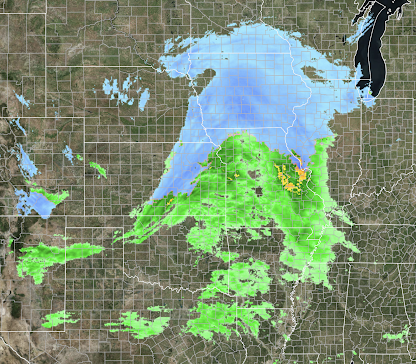
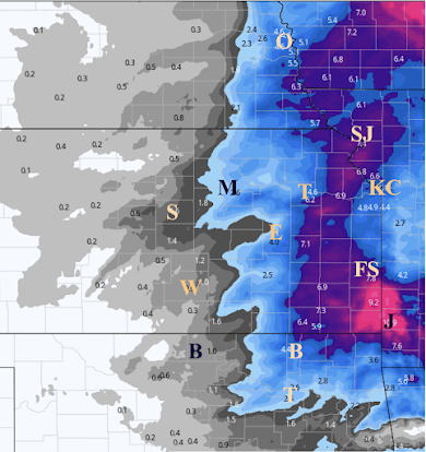
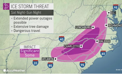
Please factor these forecasts into your plans. Ice Storm in Southeast - Power Failures Possible.  Specifically focusing in on the potential for power failures, the greatest chance is in the area in darkest green, which includes Charlotte.  Recommendations: Fill your car with fuel.  Purchase grocery and prescriptions needed for at least three days.  Make arrangements for friends and relatives who may need it. Keep items like phones and laptops on chargers.  Get some extra cash.  Snow Amount Forecasts The heaviest amounts will occur in Iowa near Des Moines and Ames.  While these amounts should be considered preliminary, I have moderately high confidence at this point.  Finally, below is a map of NWS advisories.  Pink = winter storm warning.  Gold = high wind warning.  Maroon = high wildfire danger.  Sand = wind advisory (lesser condition). Purple = winter weather advisory.  Dark green = winter storm watch.