Posts

Showing posts with the label transportation

Flood and Rainfall Forecast (Updated, 11:10am)

Image
Catastrophic flooding now forecast (pink). "Considerable" flooding is dark blue and "limited" flooding is forecast in the pale blue area. It is possible that I-10 and other highways may be closed in spots before this is all over. I'm certain evacuations will be required.  Torrential rains are expected to occur in southwest Texas during the next seven days. Major flooding is already occurring west of San Antonio.  These additional rains will likely cause record flooding.  The rain in the intermountain region will be of net benefit although isolated flooding (especially in burn scar regions) will occur. 

3:30pm CST Winter Storm Forecast

Image
I continue to forecast major snow and ice storm roughly in between I-70 on the north and I-20 on the south. The forecast track of the storm has moved north since yesterday.  Note: I have comments on the meteorology behind this forecast at the bottom.  The winter storm will begin Friday in the southern Great Plains and then spread rapidly east.  The Ice Storm Potential For those who have never experienced a major ice storm, they can do damage on the order of a tornado but over a larger geographic area. Power failures in major ice storms are extensive and can last for days or even weeks.  Here is the best available forecast of freezing rain accumulation. The amounts from this system can be a little on the high side but generally they are reasonable. These amounts are more than sufficient for significant power outages! The NWS system for judging the greatest ice storm danger is in the red area. However, I believe the risk is just as high in North Carolina and Virgi...

4:30 pm CST, Updated: Huge Winter Storm and Cold Wave in Store

Image
This is a weather event for which preparations are absolutely necessary: ice storm, heavy snow, and prolonged extreme cold.  2014 South Carolina ice storm Please note: freezing rain (glaze ice) is forecast to fall in significant amounts at the airline hubs in Dallas, Atlanta, Charlotte with significant snow in Washington D.C. If you are planning to fly to those cities (or others in the winter storms maps) I would plan to arrive Friday morning or before or  would get on the phone to reservations and re-route around those hubs. Otherwise, the possibility exists of being stranded for days. Special update regarding the Hurricane Hunter's role in this serious storm at the bottom. Storm Timing This is a forecast radar for 4am Friday as the storm is getting started. Over Arkansas to the Tennessee River the precipitation may still be aloft and not actually begin for a few more hours.  Winter Storm Watches It is rare winter storm watches are issued more than 48 hours in advance bu...

7:10pm Friday - Updated Hurricane Beryl Forercast

Image
The red arrows represent the range of where I forecast landfall of Beryl's center.  I now believe the entire Texas Gulf Coast is in play as to landfall. I was leaning toward that change in this forecast update. The arrival of the 18Z European Model forecast sealed it.  Wind Speed Forecast: if Beryl strikes near or south of Corpus Christi, wind speeds will be around 85-90 mph. If the storm strikes north of Corpus, wind speeds could be in the 90-100 mph range.  Tbe National Hurricane Center's Hurricane Watch is shown in pink along the central and southern Texas coast. I believe they will have to extend the watch farther north in later advisories.  The flood forecast is here . There will also be a storm surge near and north of where the center makes landfall. Finally, there will be a few tornadoes.  I will update this forecast again Saturday morning 

Update on Approaching California Storm: Updated 2:30pm PST

Image
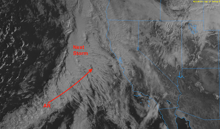
Latest satellite image shows the next storm off the coast of California as well as the atmospheric river (AR) attached to it.  Additional Information: The researchers at Scripps just tweeted about this situation and their analysis is essential the same as mine.  Below are the forecast model precipitation amounts map between now and Wednesday night.  Here is the National Weather Service's latest forecast precipitation amounts from 4pm this evening to 4pm Wednesday. The storm is taking a slightly more southern path and only light to moderate amounts are forecast in southern Oregon.  Here is a forecast of snow in the Sierra. 

Sunday Fun: "If the Tornado Doesn't Come to the Mobile Home, Take the Mobile Home to the Tornado"

Image
As I was taking photographs of the supercell thunderstorm in Chase County, Kansas , Wednesday evening, I didn't get to see Channel 3's excellent storm coverage. Kathleen taped it for me, and I was amused to see a mobile home being hauled toward  the tornado*! Because it was dark, they could show the tornado only during lightning flashes. Here's a better view of the tornado. Fortunately, there were just three minor injuries and the damage was not severe.  *If you look at the lower right, you'll see a flashing red light. That is the end of a BNSF train stopped by an AccuWeather track-specific tornado warning. 

My Photography Is Now Available on Shutterstock

Image
I am pleased to report that my photography is now available on shutter stock , the world's largest library of stock photography. This is in addition to my photography on Adobe Stock Photography .