Posts

Showing posts with the label Tulsa

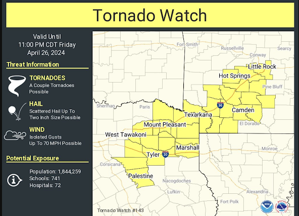
Nighttime Tornado Risk: Kansas and Oklahoma

Image
Here is the forecast for severe thunderstorms and tornadoes until 3am. There is also a threat of flash flooding in a few spots.  Forecasts below are until 7am.  Kansas Threat Till 7am in Brown  Oklahoma Threat till 7am in Brown NWS Storm Prediction Center is forecasting a significant chance of a tornado or two in the brown area between now and 7 am Tuesday., Please monitor the weather the rest of the night and make sure you can quickly get the family into you storm shelter area. 

Tornado and Severe Thunderstorm Forecast for Tuesday

Image
It looks like tomorrow will be a major tornado and severe thunderstorm day in the Midwest. I recommend people start planning accordingly. There is a high  risk of damaging storms. Tuesday's Tornado Risk There is an enhanced risk of strong tornadoes  in the yellow, hatched area. There is a significant risk of tornadoes in the brown area.  Tuesday's Damaging Wind Risk Here is the color code for this forecast: Purple: a high risk of wind gusts of 75 mph or stronger. Red, hatched: there is an enhanced  risk of wind gusts of 75 mph or stronger.  Red (only): an enhanced  risk of wind gusts of 60 mph or stronger.  Yellow: a significant risk of wind gusts of 60 mph or stronger.  There is also the risk of large hail in the above areas. A derecho may occur. Please factor this forecast into your plans Tuesday and Tuesday night.  Yesterday's forecast , unfortunately, worked out pretty well. It is almost certain there were more tornadoes in Kansas than sh...

6 pm - Current Tornado Forecasts

Image
Tornado Watch until 11pm. Tornado Watch until 9pm. This watch has been cancelled for Kansas.    Tornado Watch until 9pm.   More tornado watches are below, please scroll down.  Tornado Watch until 7pm. Updated Forecast  The yellow, hatched area has an enhanced risk of tornadoes. The brown area has a significant risk. Kansas City has been removed from the enhanced risk of tornadoes but remains in the significant risk.  Below are close-ups of the tornado risk areas. Please keep up on the weather in these areas, especially if you live in the hatched area. You can follow my real-time updates on Twitter @usweatherexpert.  You may wish to recommend this blog and my Twitter handle to friends and relatives in the affected areas.  If you, for example, live in the mobile home and need a community shelter, a list and map is here .  I am going to make a separate posting for tomorrow's tornado forecast. It should be up early this afternoon. 

Updated Freezing Rain Forecast: 5:10pm Saturday

Image
Color code: Freezing rain possible.  Freezing rain likely. Forecast Valid: 4pm Sunday to 4pm Monday This updated freezing rain forecast has lessened the chance of ice in north central Texas, including the Metroplex as it has been moved from the "likely" to "possible" category north of I-20. The latest guidance indicates there could be some isolated power outages. It is too soon to outline where they might be. The entire area in red will have difficult driving conditions Sunday night and Monday morning.  Please check back for additional updates tomorrow. 

Downburst West of Tulsa

Image
Here is a shot of the rain shaft associated with a weak downburst at 5:40pm southwest of downtown Tulsa.  You can see Tulsa's Riverside Airport in the foreground. Downbursts, even of this intensity, are dangerous to planes when they land and take-off when they are over airports.  The radar at the same time shows the storm. On the left is the reflectivity image which shows how hard it is raining. On the right is the wind. The greens are colors showing winds blowing toward the radar and reds away from the radar. The peak gusts weren't all that high, about 35 mph.  

Tulsa - Another Tornado Warning Miss

Image
Tulsa World From the Tulsa World : A surprise tornado caused chaos across the Tulsa area Wednesday night in a storm that earlier in the day had only a “limited tornado threat.” The National Weather Service issued the first tornado warning at 7:19 p.m. — with no previous tornado watch in effect — and within minutes of the warning said a tornado was on the ground three miles southwest of  Catoosa moving at 50 mph. Damage on 18th floor of a high-rise building Tulsa World Based on the news photography I have seen, this tornado will be rated at least EF-2 -- another significant tornado without advance warning .  Here is a map of the approximate path of the tornado's rotation.  The Doppler wind radar data showed that a tornado warning should have been issued at 7:11pm for what meteorologists call a "QLCS tornado." Reds are winds away from the radar.  Greens are winds toward the radar. By 7:15pm, there was unquestionably a tornado on the ground as evidenced by the Doppler ...