Posts

Showing posts with the label Ozarks

Remember When Newspapers Had Copy Editors?

Image
A bit of wistful thinking in the Ozarks....

7-Day Rainfall Amount Forecast

Image
More than five inches of rain is forecast to fall over the Ozarks during the next seven days. The band of heavier rain is forecast to extend east into Tennessee and Kentucky. Little to no flooding is expected because the region ranges from dry to moderate drought conditions. 

#1 Worst Lake Weather This Weekend

Image
For the 2025 Memorial Day Weekend, it is -- unfortunately -- easy to find the forecasted worst Lake Weather.  Yes, that is more than 7" of rain at Table Rock (MO) and Bull Shoals (AR) in the Ozarks. Nearly 7" (tiny spot, look closely) is forecast for the Lake of the Ozarks (MO) as well 5" at Grand Lake (OK).  As a result of the heavy rains earlier this week, considerable debris is already being observed in the water at the Lake of the Ozarks and this will be a problem at all of these lakes by the end of the weekend.  In addition, flooding is likely  in the 4-state area with the orange and amber colors. 

Tornado Risk Today- Updated 2:15pm; 4th Tornado Watch

Image
-- original forecast, still valid -- Yesterday saw many tornadoes in the central Plains, several of which were strong. I believe we are in for another day of severe weather only this time a bit farther east.  Here is the color code for this forecast based on my 4-point scale. Note: the highest on my scale is an extreme risk which is  not  being forecast today.  Red, hatched =  high  risk of strong tornadoes.  Yellow, hatched =  enhanced  risk of strong tornadoes.. Brown = a significant risk of tornadoes.  Large or very large hail is likely over this same region. Damaging Winds The purple hatched area has a high  risk of wind gusts of 75 mph or stronger. The red area has an enhanced risk of wind gusts of 60 mph. The yellow area has a significant risk of gusts of 60 mph or stronger.  Safety Recommendations If you live in a mobile home or need a public shelter, you will find lists and maps  here . Please check it now, before ...

Updated Tornado and Damaging Wind Forecast: 8:25am

Image
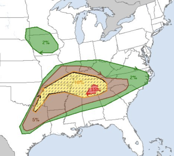
This is an important day to keep up on the weather in parts of the Ozarks,  Ohio Valley and into the Middle Appalachians. Tornado Risk On my 4-point scale (the highest is the rare "extreme" which is not in today's forecast), here is the legend: Red, hatched = high  risk of tornadoes with some of the storms strong (EF-2 intensity or greater). Yellow, hatched = enhanced  risk of tornadoes, some strong.  Brown = significant risk of tornadoes.  Damaging Wind Risk Map legend: Pink, hatched = high risk   of wind gusts, some 75 mph or stronger.  Red, hatched = enhanced  risk of wind gusts, some 75 mph or stronger. Yellow = significance risk of wind gusts of 60 mph or stronger. A derecho is possible. Please keep in mind that wind force is logarithmic which means that an 80 mph gust is significantly more damaging than a 60 mph gust.  Safety Recommendations If you live in a mobile home or need a public shelter, you will find lists and maps  ...

Friday's Tornado and Damaging Wind Forecast

Image
This forecast has been updated.  Click here for the latest forecast.  Preliminary Friday Forecast looks to be a major severe weather risk  day from the  Ozarks then east up the Ohio Valley.  The yellow, hatched area has an enhanced  risk of tornado with some likely strong. The brown area has a significant risk of tornadoes.  Here is an expanded look at the entire significant tornado risk area.  Damaging Wind Risk Here are the risk categories: Purple hatched, including St. Louis, Cape Girardeau, and Terre Haute, has a high  risk of thunderstorm wind gusts of 75 mph or stronger.  Red hatched, an enhanced  risk of wind gusts of 75 mph or stronger.  Yellow, a significant risk of wind gusts of 60 mph or stronger. It is possible that a derecho will form in Missouri or near the Mississippi River and move east.  If you live in a mobile home or need a public shelter, you will find lists and maps here .  With this combination...

Flood Risk Starting This Weekend

Image
Here is the forecast rainfall from now until 7pm Sunday: The orange is more than five inches  near I-44 in southwest Missouri and northeast Oklahoma from now The total in the same area is more than seven  inches from now until 7pm next Thursday.  Serious flooding is likely to result from southeast Missouri into eastern Oklahoma. Please prepare accordingly. 

Today's Tornado Risk - Updated 8pm

Image
7:55pm A tornado watch is now in effect until 1am. Please note that tennis ball-sized hail and 80 mph thunderstorm-generated gusts are forecast.  3:20pm Kansas:  As of 3:10pm, a line of tower cumulus clouds is growing along the dry line in Kansas. I expect thunderstorms to form along the dry line by around 5pm (give or take). These storms may produce large hail this evening near and southeast of the Kansas Turnpike.  Later tonight, a cluster of storms with damaging winds is likely from SE Kansas and Oklahoma into Missouri. You may wish to bring in trampolines and outdoor furniture that could blow about.  Oklahoma:  No tower cumulus yet but when/if thunderstorms develop, they will grow very quickly and could become quite severe.  --- original posting (still valid) --- The NWS Storm Prediction Center has added a significant chance of tornadoes in a part of Oklahoma this afternoon and evening.  As Norman and Stillwater, as well as OKC and Tulsa, are inclu...

6:40pm Update: Winter Storm Watch

Image
---- Please note: this forecast has been updated.  The newer forecast is here . ---- --- original forecast below --- A winter storm watch is in effect for much of north Texas and southeast Oklahoma. This is updated from this morning.  The winter storm watch includes the DFW Metroplex as well as Little Rock and Shreveport.  Below are my preliminary snowfall amounts.... The snow in north Texas should begin Thursday afternoon and spread north and east thereafter.  Temperatures are going to be bitterly cold. Please make cold weather preparations now!!

Updated 5:50pm: Tornado Forecast for Today and Tonight

Image
Newest Tornado Watch As mentioned below, it turns out the chance of tornadoes south of my red outline has increased. Please keep an eye on the weather in this region the rest of the evening..until midnight. My Forecast Until 8pm I believe there will be several tornadoes yet this afternoon and evening in the red outlined area. Please continue to monitor the latest weather information for possible warnings. There is also a lesser risk of tornadoes in the Texarkana to Paris to Tyler area. It would be wise to keep an eye on the weather in that area, also.  Forecasting note for meteorologists: Since the mid-1970's, we've known that scattered supercells ahead of a line are a favored area for tornado formation. That is probably going to be the case this evening.  New Tornado Watch, 1:35pm 2:20pm Update Two independent forecast techniques indicates that the risk for tornadoes is rapidly increasing in the outlined area. This includes southeast Kansas which was not highlighted in other...

3:50pm: Giant Hail and High Winds: Central Plains & Ozarks

Image
New severe thunderstorm watch issued at 3:40pm until 11pm.  Severe thunderstorm watch has been extended to 6pm.  Note that 75 mph wind gusts and tennis ball-sized hail are forecast.

[8:25pm] Tornadoes and Damaging Winds Forecast for This Evening and Tonight

Image
Tornado and Extreme Winds Forecast in the Midwest Please bookmark: www.mikesmithenterprisesblog.com We provide unique coverage of tornadoes, derechos and other types of extreme weather.  Also, I provide live coverage of tornadoes and other major storms here: @usweatherexpert Please call friends and relatives and make sure they are aware of these forecasts! 8:25pm - Northern Arkansas Tornado Watch  7:17:pm -  Illinois Tornado Watch  6:45pm - Wisconsin Tornado Watch  6pm Update - New Tornado Watch  There are tornado-bearing thunderstorms near the west side of this watch, so people need to be monitoring the weather the rest of the evening.  I will be updating on Twitter @usweatherexpert.  4:05pm Update This tornado watch until midnight includes Madison, Janesville and Milwaukee. Please monitor the weather closely in these areas. I also update on Twitter @usweatherexpert.  2:45pm Update I am confident tornadoes will occur in this watch. In additi...

Overnight Tornado Forecast Update 8:50pm CDT

Image
After another eight hours, this ends my coverage for the night. Below are forecasts for the remainder of the night, please look them over.  Tornado Forecast for the Rest of the Night In the red, there is a high  risk of tornadoes, some strong, between now and 1am The yellow hatched area is where there is an enhanced  risk of strong tornadoes the rest of the night.  The brown area has a significant risk of tornadoes until 7am Thursday New Tornado Watch Until 3am CDT Thursday This is one of the most extraordinary radar images I've ever seen. This is the Dopper wind velocity data for the east half of Tennessee and far northern Alabama. I've the circled the rotation for each of the tornado warnings (red polygons).  809p CDT Severe thunderstorm and tornado risk increasing as more storms from from around Dallas to points northeast. Please monitor the area in the red outlined area.  Above is the radar and tornado watches (amber) as of 7:10pm. Storms are...