Posts

Showing posts with the label Ohio

Second Tornado Watch Issued

Image
Second Tornado Watch First Tornado Watch Tornado watch in effect for "a couple of strong tornadoes" from now until 7pm CDT. It includes the south part of Chicagoland, the Quad Cities and western Indiana. Please monitor the weather the rest of the day! I am providing real-time updated information on Twitter @usweatherexpert.  --- Tornado Forecast Until 7am CDT --- The yellow, hatched area has an  enhanced risk of strong tornadoes this afternoon and evening. The brown area, which includes Chicago and the Quad Cities, has a significant risk of tornadoes. With the 11:10 update, Ft. Madison and Dubuque have been added to the brown area. In the meantime, please make sure your shelter area is cleaned out and read to go with a couple of bottles of water, shoes (if your home is hit you don't want to walk barefoot on debris), and diapers if appropriate.  If you live in a mobile home, it is important to find other shelter. If you do not have friends or family in a nearby conventiona...

3:20pm EDT Update -- Tornado Watch Issued

Image
Tornadoes are likely  in this region. Please monitor the weather throughout the late afternoon and evening.  --- original ---  There is an enhanced  risk of tornadoes in the orange area with a significant risk of tornadoes in the yellow area.  Please keep an eye on the weather in this area. 

Today's Tornado Risk: Pennsylvania, Ohio, and West Virginia

Image
5:10pm Update Here is the radar at 5:04pm. The pink tinting is a severe thunderstorm watch for 70 mph winds and 2" hail along with "one or two tornadoes." The yellow is a severe thunderstorm warning in effect at that time. Please monitor local weather conditions this evening if you live in the pink areas.  ---- The brown area is a signifiant risk of tornadoes from around Altoona to west of Canton, Ohio. The red area has an enhanced  risk of wind gusts of 60 mph or stronger which means tree damage and consequent power outages. This includes State College and Bloomsburg. The yellow area has a significant risk. The yellow area has a significant risk of 1" or larger hail which the hatched area may see 2" or larger hail.

Today's Tornado Risk

Image
There is an enhanced  risk of tornadoes in the yellow area. There is a significant risk in the brown area.  There is also a tornado watch in effect for Florida that I am covering on Twitter. 

Tornado Watch Illinois, Indiana, Ohio, Kentucky

Image
The tornado watch is in effect until 6am EST. Please monitor the weather over this region the rest of the night. Turn on your weather radio, WEA or your GPS weather app. I am also tweeting  @usweatherexpert. 

Tornado, Hail, and Wildfire Forecast for Tuesday [Updated, 4:45pm]

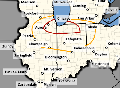
Image
There is a significant risk of tornadoes tomorrow in the Midwest after about 4pm. The first of the severe thunderstorms will probably develop over Illinois. The area in orange has a significant risk of a tornado. The area in red, which includes Chicago, has an enhanced risk.  There is also a risk of giant hail -- two inches or larger -- in the hatched area. In the remainder of the yellow area, there is a significant risk of 1" or larger hail. There is also a critical wildfire risk of wildfires in the red area over the southern High Plains.  Of course, I will update on these risks tomorrow.