Posts

Showing posts with the label Georgia

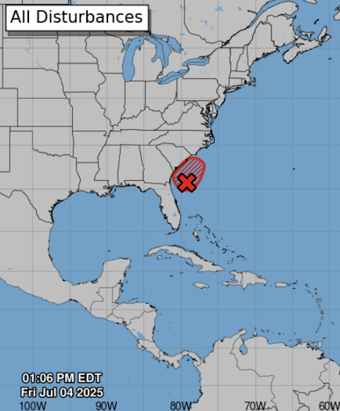
70% Chance of Tropical Depression Development

Image
There is a 70% chance of tropical depression or storm development in the next 48 hours in the area outlined in red. Please monitor the weather along the Georgia and South Carolina coasts through the holiday weekend. 

Overnight Tornado Forecast Posted at 7:05pm

Image
Here is the tornado forecast for the rest of the night (till 6am CST). Red, hatched = high risk of strong tornadoes. Yellow, hatched = enhanced risk of strong tornadoes. Blown = significant risk of tornadoes.  This will be the last update of the night. Tornado Watch until 2am. Please make sure you have ways of getting warnings of tornadoes and 80 mph winds.  6:15pm  NWS believes the chances for tornadoes and damaging winds are increasing in Mississippi. They also say they are going to extend the tornado watch to the east later this evening.  5:35pm: The northwest part of the tornado watch has been cancelled Here is the area where tornadoes are more likely from 4:30 to 7:30pm. From Atmosphere Analytics Rare "Particularly Dangerous Situation" Tornado Watch till 9pm If you live in these areas it is vital  to monitor the weather until the watch expires at 9pm  Note the forecast is for "numerous strong tornadoes." A very rare "particularly dangerous situation" ...

Comprehensive Update on Tropical Storm Helene; Update 11pm

Image
NHC is now forecasting sustained winds of 120 mph at landfall which would be a strong Cat 3 hurricane. People in Tallahassee should prepare for hurricane force winds.  Next update will be tomorrow morning.  ---- The newest satellite image (6:54pm) shows Helene developing rapidly. This lends credibility to the forecasts and I urge you to follow the safety recommendations.  ----- 5:15pm update below ---- Hurricane Helene is forecast to come into the Florida Panhandle late Thursday with high winds and a major storm surge ahead of the center. Here is a complete update on the storm. Please forward this information to your friends and relatives.  Hurricane Warnings  have been issued for parts of the Gulf Coast of Florida. The central pressure has dropped to 995 millibars (as of 6pm) 992 990 millibars at 8pm and the maximum sustained winds are 50 60 mph. There are also hurricane warnings for Cancun and the northeast Yucatan. The Forecast Path of the Eye of Helene Her...

10:05pm Forecast for Hurricane Debby

Image
As of 10pm, sustained winds of Tropical Storm Debby are 45 mph and the central pressure is 1003 millibars.  The highest sustained winds at landfall are forecast to be 85 mph. Extreme rainfalls with flash and river floods likely in northern Florida, Georgia and South Carolina. Flooding by occur in far southern North Carolina.  With the higher wind speeds, the storm surge heights have been adjusted upward.  This is a life-threatening storm surge forecast.  Tornadoes are possible Sunday and Sunday night in the green. 

6pm Update on Tropical Storm Debby - Hurricane Warning Issued

Image
 Below is the radar from 5:49pm. A center has formed and Debby is moving northwest. I have underlined Miami, Key West and Cape Coral to orient Florida. Red is a hurricane warning. Pink is a hurricane watch. Blue is a tropical storm warning. The amber area is the current area of tropical storm force winds (39-60 mph). S = tropical hurricane. H = hurricane.  Debby is only expected to move about 70 miles to northeast after 2pm Tuesday. That is why makes the potential rain event so dangerous.  The widespread 7 to 15" amounts near the coast will cause catastrophic flooding. Please prepare now! In addition a life-threatening storm surge of up to 7 feet is likely along the Florida Big Bend.  Finally, there is a significant risk of tornadoes Sunday and Sunday night in the green area. 

Tropical Storm Forecast for Florida - 5:30pm Friday

Image
The weak weather system now over Cuba is forecast to become Tropical Storm Debby off the coast from Naples Saturday evening. It is then forecast to move across Tampa with 60 mph winds (with gusts to 75 mph) and then curve northeast reaching the Jacksonville area by sunrise Monday. Blue = tropical storm warning and yellow = tropical storm watch.  Here is the storm surge forecast. Beyond Monday morning, the forecast becomes much more uncertain.  The models I trust the most have the system as a strong tropical storm from near Amelia Island to about Myrtle Beach. Then, they either move it inland or have it weaken near the South Carolina or North Carolina coasts. Vacationers to these areas should take the forecast for early next week into consideration.  The NWS is forecasting as much at 7" of rain (amber)in the coastal Carolinas (the yellow, 10" area, if off the coast.  I am forecasting a chance of tornadoes just about anywhere over the Florida Peninsula until the storm ...

Tropical Depression Likely

Image
Remember, the primary threat of a tropical depression is heavy rain and possibly flooding. If the wind speed gets to 40 mph, it would become a tropical storm.  I will continue to mentor this for you. 

Tornado and Severe Thunderstorm Outlook for Thursday

Image
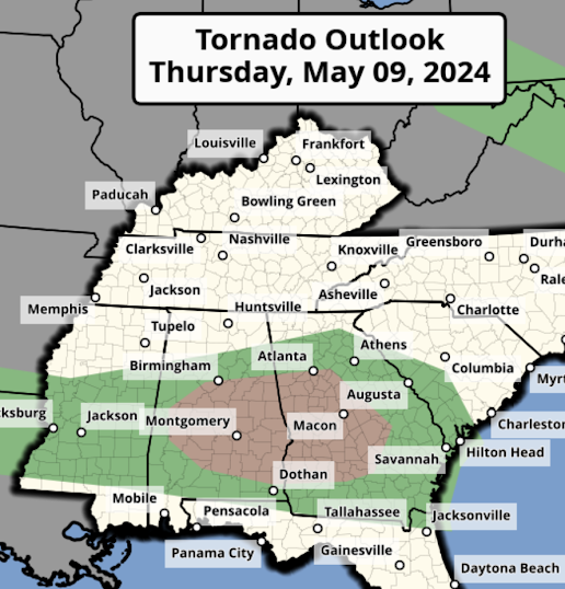
We have one more day of tornadoes and severe thunderstorms and then Mother Nature will be giving us a break.  Tornado Forecast The area in brown has a significant risk of tornadoes.  Damaging Wind Forecast The hatched area has the potential for winds of 75 mph or stronger along with power outages. The unhatched areas have the potential for gusts of 60 mph or stronger.  Large Hail Outlook The hatched area is where hail stones 2" or larger are forecast to fall.  I will update this outlook Thursday morning.

Poorly Warned Georgia Tornado

Image
Last Saturday, an EF-2 intensity tornado injured five in far southeast Georgia. Unfortunately, the National Weather Service's (NWS) warning for this tornado was less than adequate.  Radar Review One of my goals in publishing these reviews is so that young meteorologists may benefit from my 53 years of radar experience in severe storms. So, we are going to review this storm in some detail.  The above image is from 1:20pm when a circulation forms near Hoboken, Georgia. Rotation is shown in the right panel. From this point on, the storm should be closely watched, but I would not issue a tornado warning at this time.  At 1:25pm, the rotation has tightened a bit and, with a "significant tornado parameter" of 1, a tornado warning should be considered, but I probably would have held off a bit longer to insure the rotation was well organized.  At 1:28, the strong rotation has narrowed and I'm quite confident I would have issued a tornado warning at this time. The warning fro...