Posts

Showing posts with the label GOES

GOES-U on its Way to Orbit

Image
The launch of GOES-U, a new weather and solar observation satellite, went off without a hitch this afternoon. Congratulations to NOAA, Space-X and the NWS. 

Amazing Satellite Animation of the Volcanic Pressure Wave

Image
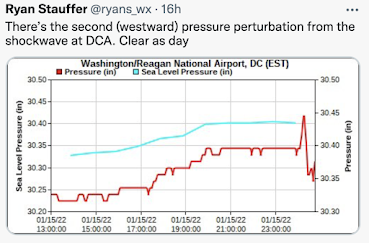
Saturday, we walked about the barometric pressure wave from the Tonga volcano explosion as it moved across the United States. For example, the red line (below) shows the very rapid fluctuation in barometric pressure at Washington, DC.  The Pacific GOES-17 weather satellite's sensors (not of the type you see in television weathercasts) was used to created an animation of the wave as emanated from the eruption. A screen capture is below. The animation is here . Just amazing. Thanks to William Barlow for the animation. 

Horrific Rainfall Rates in Much-Suffering Houston

Image
As we warned below (scroll down), Houston is experiencing another round of major flash flooding that will likely make the news tomorrow. Below is a weather satellite image of the storms. Downtown Houston is just south of where the freeways intersect. The blacks are, generally, rainfall rates of 1 to 1.5"/hr. The grays are higher rainfall rates. In one case, a confirmed (via rain gauge) rate of 9.5"/hour was observed for a short time. Everyone's advice to Houstonians is to stay put and don't drive. I was tweeting about this today. Again, my Twitter handle is:   @usweatherexpert .