Posts

Showing posts with the label Denver

C'mon Denver, Do Much Better

Image
In 2011, Joplin found out there are serious consequences to sounding the sirens too often. Please sort out the problem and insure it never happens again. 

To: President-Elect Trump and Elon Musk

Image
Kansas wheat ready for harvest. Move the Department of Agriculture to where farmers grow crops. As you are looking for ways to save money and make a refocused federal government run better, here's a suggestion: Disperse the Federal Government. Move much of it far outside of the Beltway. Here are some examples of where the shrunken departments should go: Department of Agriculture to Kansas City or Wichita Department of the Interior, Denver* Department of Transportation, Chicago You get the idea. In addition, Congress should suspend civil service regulations so that good people move and the less productive are given a "buyout."   The use of government jets needs to become the exception rather than the rule. Cabinet secretaries should fly first class commercial. When they do so, they should pass through the same TSA nonsense the rest of us have to go through. The advantages of this are vast. Let's consider the ag department: Having Agriculture department employees in tou...

[Update 7:42pm MDT] Extreme Winds Continue in Colorado

Image
An update on wind gusts... Here is the updated forecast: The power outages as of 4:02pm MDT.  The outages have nearly  tripled in the past 45 minutes! Winds are gusting to 80 mph in part of the area. Power is out in much of Jefferson Co. (orange) and power outages are increasing.  Winds are forecast to gust up to 100 mph tonight. Please put outdoor furniture indoors and anything else that can blow about.  Don't be hit by flying trampolines. 😉 I am providing considerable additional coverage on Twitter @usweatherexpert. 

Wednesday: Updated Tornado and Heavy Snow Forecasts

Image
The tornado forecast has been updated. Go here .  The snow forecast has been updated. Go here .  --- original post --- Here is the forecast for Wednesday for Snow and Tornadoes... Colorado and Wyoming -- Updated 2:40pm MDT Here is the color code: Pink = winter storm warning.  Purple = winter weather advisory. Dark blue = winter storm watch. Magenta = very high wildfire danger, go here for more information .  The winter storm warning includes Denver and parts of I-70 and I-25. In downtown Denver, 6-12" is predicted to fall, although there are some models that are showing more. The most significant snow will begin tomorrow night. This is forecast to be the biggest snowstorm in at least three years.  Tornado Threat - Updated 3:35pm CDT The brown area, which also includes Tuttle Creek, Lawrence and Ft. Scott has a significant risk of tornadoes Wednesday afternoon and night. I have also added a dashed brown line. It outlines an area where -- if any strong thunderstor...

Tornado Hits South Denver

Image
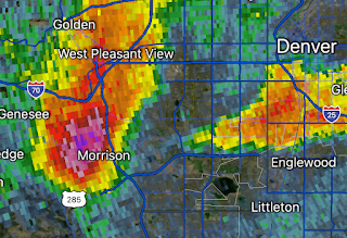
The blue and white area of south Denver Metro (click to enlarge) is where the tornado occurred. There are uprooted trees throughout the area. I don't know if there is damage worse than that or injuries.  UPDATE: The tornado has been rated EF-1. Update: Here is a more detailed path estimate.  Update: This type of damage is very common, along with blown over fences. There are scattered reports of other types of damage but they do not appear to be widespread. Also, there was large hail. Remember, the NWS's/Univ of Okla scale is in millimeters. 

More on the Last Night's Hail Horror at Red Rocks

Image
Last night's radar at 10:23pm  as hail up to tennis ball size pelted Red Rocks Here is a list of the weather conditions pertinent to the hail horror at Red Rocks Amphitheater last night.  It is questionable that things were not stopped when lightning first arrived in the area. Having personally worked with dozens of venues across the USA, the failure to cancel the evening instantly when the severe thunderstorm warning was issued at 9:04pm, is confounding.  One would think the venue industry would have learned its lesson in 2012 with the Indianapolis State Fair stage collapse and resulting deaths in injuries (including lifetime paralysis).  In my work with venues, I found some attorneys have advised their clients to "play dumb" when adverse weather approaches. Their theory is that, if the venue does nothing, whatever occurs is then an "Act of God." I'm no attorney, but as a forensic meteorologist, I doubt that would play in court in 2023.  BTW: Hail fell at ...

Today's Tornado and Hail Risk

Image
The area where there is a significant chance of tornadoes and damaging winds is in the northeast corner of New Mexico and the westernmost counties of the Texas Panhandle.  Unfortunately, this is another day with a giant hail (hatched) risk along the Front Range, including Denver. Last night, a hailstorm struck the Red Rocks Amphitheater west of Denver. People were hospitalized with broken bones and other injuries. Based on the information available at this time, they venue waited too long to stop the show with highly unfortunate results.  One would think that after the Indianapolis Stage Collapse that venues would stop "playing dumb" when it comes to weather. 

Rain and Hail

Image
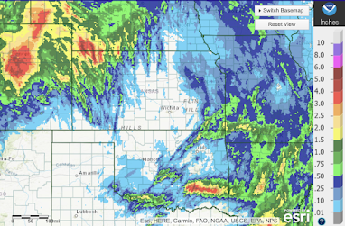
Below is the 24-hour rainfall ending at 7am. It was one of the wettest days in Denver in years.  Below is the 7-day rainfall for the same geographic area. Please note the different color scale.  Below is a map of hail tracks. The large hail west of Dallas may have damaged the wheat. Unfortunately, the color scale is in millimeters. 

Update on Colorado Blizzard Conditions

Image
Here is the forecast radar for 7am CST Tuesday. The snow is forecasted to occur farther south over the Colorado Plains. If this forecast is correct, it means blizzard conditions over most of eastern Colorado and the storm will affect I-70, I-76 and U.S. 50 as well as I-25 north of Colorado Springs. In addition to heavy falling snow, winds will gust to 50 mph.  Also, if this forecast is correct, it means snow and strong winds are possible in the Denver Metro.