Posts

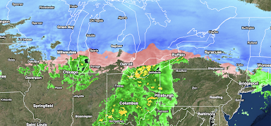
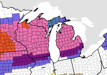
Blizzard Winding Down

Image
The blizzard is moving east. Above is the radar from 10am.  Below is current warnings. Orange is a blizzard warning; pink is a winter storm warning.  Dark blue is a winter weather advisory. Gray is a dense fog advisory.  Numerous major highways as far west as Wyoming are still closed. 

2.4 Million People Without Power

Image
The ice storm has caused extensive power outages near the Great Lakes and in Upstate New York. It is going to an extended outage for many. DTE Energy, which serves Detroit and southeast Michigan, says it has " no estimate " as to when everyone will have power restored. Others says "most" will have power back on by Saturday. 

Power Outages Mounting Up

Image
Radar  as of 8:52pm CST. Salmon color is freezing rain.  Note: As of 8:50pm, approximately 1.5 million  people are without power. The numbers are still rising. -- original posting -- Ice Storm Warnings (deep purple) have been increased in size and now includes the City of Detroit. Note: Orange is a blizzard warning, pink is a winter storm warning and blue is a winter weather advisory.  Power Failures Mounting Up These are the latest power outage numbers from the Great Lakes Region ice storm. Keep in mind that each "customer" is one home or business. Typically, there is about 2.5 people/customer. 

Additional Snow Forecast: 6pm This Evening to Saturday 6pm

Image
Here is the latest forecast for additional  snow starting at 6pm this evening.  Winter storm warnings (pink) have now been posted in New England. These are the warnings in effect as of 3:30pm CST. Color code: Orange = blizzard warning Deep purple = ice storm warning (go  here  for details) Magenta = high wildfire potential Browns and golds = various high wind warnings (brown) and advisories.  Pink = winter storm warning  Deep green = winter storm watch  Purple = winter weather advisory (lesser condition) Pale blue = extremely cold wind chill Yellow = tornado watch  Amber = severe thunderstorm warnings as of 3:35pm 

Ice Storm Update: 2:45pm Wednesday

Image
The ice storm warnings are in deep purple. Here is a view of the ice storm as of 2:35pm CST. The salmon colors indicate freezing rain with the darker shades indicating heavier rates of rain.  Ice is accumulating throughout the region. In Michigan, where the photo below (via Twitter) was taken, the freezing rain will worsen tonight.  Below is the Sperry-Piltz Ice Storm Index, which indicates severe conditions where you see purple. In those areas, multi-day power failures are possible. More scattered power failures are possible in the red areas.  Please take these forecasts seriously. 

Blizzard Warning -- Mountains Above Los Angeles and Southern Sierra [Updated]

Image
Blizzard warnings have extended into the southern Sierra (orange).  This is going to be a major storm! Color code: Orange = blizzard warning Magenta = high wildfire potential Browns and golds = various high wind warnings (brown) and advisories.  Pink = winter storm warning  Deep green = winter storm watch  Purple = winter weather advisory (lesser condition) Pale blue = extremely cold wind chill Navy blue = hard freeze warning Blizzard conditions (high winds with heavy snow), heavy snowfall amounts and flooding likely over the next seven days in Southern California.  Please note: that is more than 13 inches rain and moisture content of snow above Los Angeles. The flood  potential includes most of the state, not jus the Southland.  Additional moderate to heavy precipitation is likely beyond seven days out. 

The Warnings as of 9am

Image
Color code: Orange = blizzard warning Deep purple = ice storm warning (go  here  for details) Magenta = high wildfire potential Browns and golds = various high wind warnings (brown) and advisories.  Pink = winter storm warning  Deep green = winter storm watch  Purple = winter weather advisory (lesser condition) Pale blue = extremely cold wind chill