Posts

Rainfall Amount Forecast

Image
For the next seven days:

More Global Warming Catastrophe Reports

Image
Sarcasm on: Sarcasm off

The Tragic Story of DDT

Banning DDT was one of the human race's worst moves, ever. Why? Deaths from malaria skyrocketed after the ban. We need to bring it back. Story here .

Central Kansas: First Severe Thunderstorm Warning

Image
Large hail and, perhaps, damaging winds to 60 mph and 1" hail are possible. This will be the last update of the evening. Please monitor local sources of weather information during the night. Highly recommend the AccuWeather App for keeping you informed during the night.

Severe Weather Update: 9:15pm

Image
Thunderstorms now rapidly developing in south central Kansas, generally west of Wichita . I suggest that people in the greater Wichita area keep a close eye on the weather between now and 10:30pm. These storms may become severe. Radar is from 9:08pm. Farther west , the storms continue to grow over the High Plains. These may congeal and turn into a derecho overnight.

Damaging Wind Forecast - 8:30pm Thursday

Image
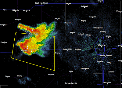
Here is the view from my back yard at 8:20pm CDT. This is of a dying thunderstorm over west Wichita. Radar at 8:24pm shows the dying storm near Wichita while near storms form quickly near Cheney Lake  (not shown) and Pretty Prairie. At the same time, thunderstorms are increasing in intensity and coverage in the High Plains. These are going to congeal over the next 4-5 hours and produce a threat of widespread damaging winds.  I agree that there will be a large area of wind damage potential over south central Kansas...in fact, I might add another 30 miles or so on the north side. Wind gusts could approach 75 mph in the red area and as far north as Hays and Russell. So, charge your phone and computer NOW (but take them off the chargers before any lightning arrives). There is a risk of scattered power failures. ---- UPDATE: 8:44PM. 8:49pm radar. And, at 8:40pm, From met back yard, the eastern (green) radar echo is in the foreground while the developin...

Two Areas of Tornado Risk

Image
The SPC has two areas of tornado risk this afternoon and evening. One is between Wichita and Kansas City and the second is between Yankton and Omaha. I suggest that people in those areas monitor local media when thunderstorms approach.