Posts

Showing posts with the label rip currents

Hurricane Erin Update

Image
Dangerous rip currents and surf will continue the next few days along the East Coast.  These are life threatening.  The 11:35am satellite image shows an eye has redeveloped in Erin with 110 mph winds. The storm is moving north, so it is easy to see that it will brush eastern North Carolina and far southeast Virginia.  Above is the forecast storm surge.  The coast outlined in blue is under warnings for tropical storm force winds. The brown is the radius of hurricane force winds and amber is the tropical storm force winds.  The wind speed is forecast to increase from 110 mph to 120mph during the next 24 hours. After that weakening is forecast as it races across the Atlantic tis weekend. 

Hurricane Erin Update

Image
This is the current forecast for Hurricane Erin's path. H = Hurricane M = major hurricane (both in terms of winds). Some strengthening is forecast the next 36 hours and then a gradual weakening.  Blue = tropical storm warning, which includes the North Carolina Outer Banks and yellow is a tropical storm watch (far southeast Virginia coast and northern Outer Banks).  For the mainland United States, the hazard is rip currents. People have already drowned.  Adults: Do not go into water deeper than the bottom of your knees. Children: stay out of the water entirely if it is deep than ankles. 

Hurricane Erin Information

Image
Here is a forecast from AccuWeather showing  when the major dangerous ocean conditions are forecast to occur. The "Stadium Effect" This is what the Hurricane Hunters see when they are in the eye of a strong hurricane. Picture yourself in a stadium with a a retractable roof that is partially open. You are standing on the field and around you are the clouds of the eye representing the bleachers/seats. Looking straight up is the sky.  Update Erin intensified quite rapidly overnight and is now Cat 4 intensity. I am covering it because it will produce dangerous, and possibly damaging, surf and rip currents along the Atlantic Coast. The National Hurricane Center did a great job forecasting the intensification.  Eric is forecast to reach a peak sustained wind speed of 165 mph later today which would make it a rare Cat 5 hurricane.  Reminder: the white outline is the forecast path of the center  of the storm. 

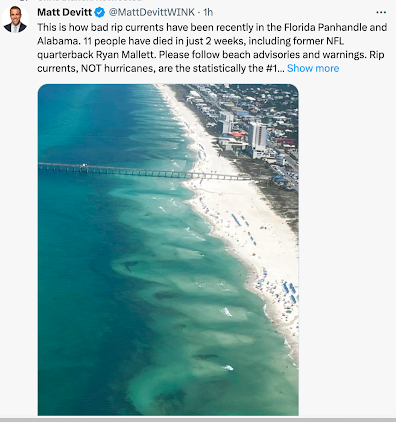
The Huge Number of Drowning Deaths in Rip Currents

Image
With the holiday weekend at hand, the caution regarding rip currents is timely. I had no idea so many were drowning in them. Vital safety information is here .  They can be easily seen from above, as in the photo, but are difficult to see at beach level. So, I urge you to follow the flags and the advisories online and on the radio.