Posts

Showing posts with the label commodities

Drought and Rainfall Update

Image
Here is the drought data as of Tuesday.  Fortunately, the areas of extreme or worse drought seems to be a little less bad than is often the case at this point in the summer. The drought map is compiled on Tuesdays. Below is a map of rainfall since that time.  Below is the rainfall amount forecast for the next five days...

Possible Flooding in the Southeast; Some Drought Relief Possible

Image
Here are actual rainfall amounts across the contiguous 48-states during the past seven days.  And, here is the forecast rainfall for the next seven days. These forecast five-inch amounts may lead to localized flooding, while the forecast rain in the central Great Plains, if they develop, will cause mild drought relief.  Below is the latest drought information: While this is not my favorite drought metric (yellow ≠ drought), it is the most up-to-date that I can provide. The wheat and ranch lands in central and western Kansas along with ranch lands in southwest Texas and New Mexico need rain. A weak, but slow moving, low pressure system should move across the central Great Plains next week and, hopefully, it will help mitigate the drought.

Winter Wheat Rainfall Maps

Image
Important rains have fallen over the winter wheat belt the past three days to 10am CST Saturday. Here is a zoom-in to the primary producing areas.  Here are point amounts from last night's rain via the Kansas Mesonet. 

Weekly Rainfall and Forecast

Image
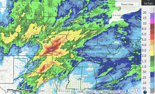
Above is the rainfall for the past seven days. Near the Missouri-Kansas border, more than 14 inches fell. Unfortunately, most of the rain missed the southern High Plains where it is badly needed. Little rain is forecast for the Southern High Plains or Southwest this week. Hey rains are likely in the South.